County Route 503 (New Jersey)
County Route 503 (CR 503) is a county highway in the U.S. state of New Jersey. The highway extends 17.95 miles (28.89 kilometers) from Paterson Plank Road (Route 120) in East Rutherford to the New York state line at the Montvale NJ/Pearl River NY border, where it continues as New York State Route 304. It parallels the Hackensack River and New Jersey Transit's Pascack Valley Line for much of its route.
| ||||
|---|---|---|---|---|
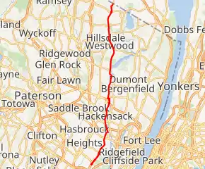
CR 503 highlighted in red | ||||
| Route information | ||||
| Length | 17.95 mi[1] (28.89 km) | |||
| Major junctions | ||||
| South end | ||||
| North end | ||||
| Location | ||||
| Counties | Bergen | |||
| Highway system | ||||
| ||||

For the northern portion of the roadway, from River Edge to Montvale, it is known as Kinderkamack Road. In Hackensack, the roadway is known as River Street and Hackensack Avenue.
Kinderkamack comes from the language of the Lenape Native Americans, meaning "place of ceremonial dance and worship." During the American Revolutionary War, General Lafayette's division camped in what is now Oradell at Kinderkamack and Soldier Hill Roads.[2]
Route description
_in_East_Rutherford%252C_Bergen_County%252C_New_Jersey.jpg.webp)
While signage directing traffic to CR 503 exists on westbound Route 3, CR 503 officially begins at Route 120. Traffic following Route 120 around the Meadowlands Sports Complex exits (or enters) in East Rutherford, while CR 503 traffic continues straight ahead into Carlstadt. Through the industrial area of the borough of Carlstadt, the four-lane highway, divided in some sections, is called Washington Avenue.
_just_north_of_New_Jersey_State_Route_4_in_Hackensack%252C_Bergen_County%252C_New_Jersey.jpg.webp)
At Moonachie Avenue, CR 503 crosses into Moonachie and becomes known as Moonachie Road. The highway continues as a two-lane road through Little Ferry, there called Liberty Street, where it intersects US 46. Entering South Hackensack, the road again becomes Moonachie Road and continues into Hackensack. At the end of Moonachie Road, CR 503 then turns left onto the four-lane River Street, which passes under Interstate 80 and the New York, Susquehanna and Western Railway's New Jersey Subdivision line. Near the Fairleigh Dickinson University campus, River Street becomes Hackensack Avenue, which shortly crosses Route 4 and then the Coles Brook into River Edge.

Near the Steuben House in River Edge, CR 503 turns left onto Main Street and crosses the Pascack Valley Line at grade before turning northward onto Kinderkamack Road. CR 503 then continues north through Oradell, Emerson, Westwood, Hillsdale, Woodcliff Lake, Park Ridge, and Montvale. Most of this ten-mile (16 km) stretch is two-lane road, but the northbound and southbound alignments split briefly in Montvale, where the highway again crosses the Pascack Valley Line at Grand Avenue.
At the New York state line, Kinderkamack Road becomes four-lane NY 304 in the village of Pearl River, becoming a limited access freeway shortly after.
Major intersections
The entire route is in Bergen County.
| Location | mi[1] | km | Destinations | Notes | |
|---|---|---|---|---|---|
| East Rutherford | 0.00 | 0.00 | Interchange with Paterson Plank Road | ||
| Little Ferry | 3.26 | 5.25 | |||
| Hackensack | 7.04 | 11.33 | Interchange | ||
| Westwood | 12.97 | 20.87 | |||
| Montvale | 17.95 | 28.89 | Continuation into Rockland County, New York | ||
| 1.000 mi = 1.609 km; 1.000 km = 0.621 mi | |||||
See also
 U.S. Roads portal
 New Jersey portal
References
- NJDOT County Route 503 Straight Line Diagram from the New Jersey Department of Transportation
- Cheslow, Jerry. "If You're Thinking of Living in: Oradell", The New York Times, November 11, 1990. Accessed August 8, 2007.
External links
| Wikimedia Commons has media related to County Route 503 (New Jersey). |