Crabtree Creek (Neuse River tributary)
Crabtree Creek is a tributary of the Neuse River in central Wake County, North Carolina, United States. The creek begins in the town of Cary and flows through Morrisville, William B. Umstead State Park, and the northern sections of Raleigh (roughly along I-440) before emptying into the Neuse at Anderson Point Park, a large city park located in East Raleigh.
| Crabtree Creek Tributary to Neuse River | |
|---|---|
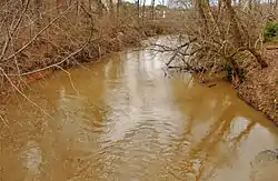 Crabtree Creek east of Lassiter Mill Rd. | |
 Location of Crabtree Creek mouth  Crabtree Creek (Neuse River tributary) (the United States) | |
| Location | |
| Country | United States |
| State | North Carolina |
| County | Wake |
| City | Raleigh Cary |
| Physical characteristics | |
| Source | between Cary, North Carolina and Apex, North Carolina, southwest of Bond Park |
| • location | Cary, North Carolina |
| • coordinates | 35°45′30″N 078°50′41″W[1] |
| • elevation | 450 ft (140 m)[2] |
| Mouth | Neuse River |
• location | about 2 miles southeast of Wilders Grove, North Carolina |
• coordinates | 35°45′59″N 078°32′22″W[1] |
• elevation | 157 ft (48 m)[1] |
| Length | 28.73 mi (46.24 km)[3] |
| Basin size | 145.27 square miles (376.2 km2) |
| Discharge | |
| • location | Neuse River |
| • average | 174.58 cu ft/s (4.944 m3/s) at mouth with Neuse River[4] |
| Basin features | |
| Progression | north, east, then southeast |
| River system | Neuse River |
| Tributaries | |
| • left | Turkey Creek Stirrup Iron Creek Haleys Branch Sycamore Creek Hare Snipe Creek Mine Creek Big Branch Marsh Creek |
| • right | Coles Branch Reedy Creek Richland Creek House Creek Beaverdam Creek Pigeon House Branch Bridges Branch |
| Waterbodies | Lake Crabtree Bond Lake |
The creek lies within a flood plain that is historically prone to frequent flooding throughout its length, even after moderate rainfall. Construction of lakes on the creek and its tributaries to control floods have only partially alleviated this problem because rapid development of Wake County has greatly increased storm runoff. Crabtree Valley Mall derives its name from the creek; when the mall was constructed, the creek was redirected into an artificial channel behind the mall. At the time of construction there were predictions that the mall would flood. In fact, the new channel of the creek at the mall has proved to be inadequate for peak flows.
The highest recorded level of Crabtree Creek, measured at Glenwood Avenue near the mall, was 27.69 feet (8.44 m) in June 1973 shortly after the mall's completion. Tropical Storm Alberto (2006) caused the second highest elevation on record, 23.77 feet (7.25 m); and Hurricane Fran in September 1996 caused the third highest elevation, 23.00 feet (7.01 m). All three events flooded the lower level of the mall, inundated the mall's parking lots, and obstructed traffic in the vicinity. Even moderate storms wreak minor havoc around the mall; for instance, a storm in June 2006 caused an evacuation of the mall and significant property damage.
In the Cary/Morrisville area, the creek was dammed to create Lake Crabtree, a 520-acre (2.1 km2) flood control lake. Lake Crabtree County Park, Raleigh's Crabtree Boulevard and Raleigh's Crabtree Park are all either named after the creek or the adjoining lake. The Crabtree Creek Trail, a branch of the Capital Area Greenway, follows the course of the creek from a location just west of Crabtree Valley Mall to the confluence with the Neuse River at Anderson Point Park.
Lassiter Mill
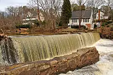
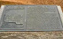
According to the City of Raleigh plaque at the site, one of Wake County's first mills was located on Crabtree Creek at a site known as "the Great Falls of Crabtree." The first mill was constructed before 1764, and the current foundations are remnants of a grist mill constructed by Cornelius Jesse Lassiter in 1908. The mill was destroyed by fire in 1958. Today, the Lassiter Mill site is a Raleigh City park, part of the greenway system, and is open to the public.
Crabtree Creek Greenway
The Crabtree Creek greenway is a 14.6 miles (23.5 km) paved trail that follows Crabtree Creek northwest from the Neuse River Trail beginning at Anderson Point Park to Lindsay Dr.[5] The final 4.1 miles (6.6 km) "east extension" section was completed in 2015 connecting the existing trail at Milburnie Road to the Neuse River Trail at Anderson Point Park. The city is planning a "west extension" (which will extend the 14.6 miles) to Umstead State Park. That project's planning will take approximately 12 months to complete with construction anticipated to begin Spring 2017.[6] The completed Crabtree Creek Trail will extend across the city, connecting numerous important areas and facilities: Umstead State Park, Crabtree Valley Mall, North Raleigh, Shelley Lake, Sertoma Park, Lassiter Mill, Kiwanis Park, and Anderson Point Park.[7]
Watershed
Tributaries
| Name, Bank | Watershed Area in Square Miles (km2)[8] | Average Discharge[9] | Mouth Coordinates[10] | Mouth Elevation[10] | Source Coordinates[10] | Source Elevation[11] | Remarks |
|---|---|---|---|---|---|---|---|
| Mouth | 145.27 square miles (376.2 km2) | 174.58 cu ft/s (4.944 m3/s) | 35°45′59″N 078°32′22″W | 157 ft (48 m) | 35°45′30″N 078°50′41″W | 450 ft (140 m) | Crabtree Creek begins between Cary, North Carolina and Apex, North Carolina southwest of Bond Park. The creek drains a large part of Raleigh, North Carolina. |
| Marsh Creek, left bank | 9.58 square miles (24.8 km2) | 13.24 cu ft/s (0.375 m3/s) | 35°47′43″N 078°35′43″W | 174 ft (53 m) | 35°52′19″N 078°37′03″W | 408 ft (124 m) | Marsh Creek rises near Northridge Country Club in Raleigh, North Carolina on the divide of it and Perry Creek. The creek then flows southeast to Crabtree Creek. |
| Bridges Branch, right bank | 0.46 square miles (1.2 km2) | 0.59 cu ft/s (0.017 m3/s) | 35°48′13″N 078°36′30″W | 197 ft (60 m) | 35°47′15″N 078°47′15″W | 300 ft (91 m) | Bridges Branch is the smallest named tributary to Crabtree Creek and drains Lions Park. It rises near St. Augustine's University and flows north to Crabtree Creek. |
| Pigeon House Branch, right bank | 4.69 square miles (12.1 km2) | 5.29 cu ft/s (0.150 m3/s) | 35°48′16″N 078°36′32″W | 190 ft (58 m) | 35°47′20″N 078°38′40″W | 280 ft (85 m) | Pigeon House Branch rises in downtown Raleigh, North Carolina on the divide between it and Rocky Branch. It then flows northeast to Crabtree Creek in northeast Raleigh. |
| Big Branch, left bank | 3.98 square miles (10.3 km2) | 4.70 cu ft/s (0.133 m3/s) | 35°49′05″N 078°37′44″W | 200 ft (61 m) | 35°51′54″N 078°37′44″W | 400 ft (120 m) | Big Branch rises in a pond on the divide between Big Branch and Mine Creek. It then flows south to Crabtree Creek. |
| Beaverdam Creek, right bank | 3.66 square miles (9.5 km2) | 4.36 cu ft/s (0.123 m3/s) | 35°49′28″N 078°38′52″W | 200 ft (61 m) | 35°48′58″N 078°39′41″W | 252 ft (77 m) | Beaverdam Creek is formed at the confluence of Southeast Prong and Southwest Prong of the creek. Most of the creek flows through Carolina Country Club. |
| Mine Creek, left bank | 10.21 square miles (26.4 km2) | 11.59 cu ft/s (0.328 m3/s) | 35°50′18″N 078°39′51″W | 210 ft (64 m) | 35°51′48″N 078°38′25″W | 395 ft (120 m) | Mine Creek rises to the west of Falls of the Neuse Road in Raleigh, North Carolina and then flows south through Shelley Lake and on to Crabtree Creek. |
| House Creek, right bank | 2.81 square miles (7.3 km2) | 3.36 cu ft/s (0.095 m3/s) | 35°50′12″N 078°40′35″W | 223 ft (68 m) | 35°47′59″N 078°42′00″W | 425 ft (130 m) | House Creek rises in a lake on the campus of the North Carolina State University Veterinary School and then flows northeast to meet Crabtree Creek near Crabtree Valley Mall. |
| Hare Snipe Creek, left bank | 7.24 square miles (18.8 km2) | 8.18 cu ft/s (0.232 m3/s) | 35°50′42″N 078°41′20″W | 223 ft (68 m) | 35°54′23″N 078°43′02″W | 430 ft (130 m) | Hare Snipe Creek rises about 0.5 miles southeast of Leesville, North Carolina and then flows southeast to meet Crabtree Creek upstream of Crabtree Valley Mall. Dammed by Lake Lynn. |
| Richland Creek, right bank | 6.84 square miles (17.7 km2) | 7.87 cu ft/s (0.223 m3/s) | 35°50′42″N 078°43′15″W | 226 ft (69 m) | 35°47′19″N 078°43′47″W | 440 ft (130 m) | Richland Creek rises in a pond at the North Carolina State Fairgrounds and then flows north through Schenck Forest to meet Crabtree Creek about 1 mile west of Raleigh, North Carolina. |
| Sycamore Creek, left bank | 16.31 square miles (42.2 km2) | 17.26 cu ft/s (0.489 m3/s) | 35°50′47″N 078°43′33″W | 230 ft (70 m) | 35°56′06″N 078°45′02″W | 440 ft (130 m) | Sycamore Creek rises in a pond about 0.1 miles northeast of Lynn Crossroads, North Carolina on the divide between it and Lick Creek. Sycamore Creek then flows generally southeast to meet Crabtree Creek about 1 mile west of Raleigh, North Carolina. Sycamore Creek flows most of its length through William B. Umstead State Park and has two impoundments, Big Lake and Sycamore Lake. Sycamore Creek is the second largest tributary to Crabtree Creek by both volume and drainage area. |
| Reedy Creek, right bank | 4.44 square miles (11.5 km2) | 5.14 cu ft/s (0.146 m3/s) | 35°50′27″N 078°44′36″W | 243 ft (74 m) | 35°47′40″N 078°45′44″W | 460 ft (140 m) | Reedy Creek rises near the WPTF radio towers in Cary, North Carolina and then flows north through William B. Umstead State Park to Crabtree Creek. Reedy Creek Lake is an impoundment of this stream. |
| Haleys Branch, left bank | 2.19 square miles (5.7 km2) | 2.51 cu ft/s (0.071 m3/s) | 35°50′18″N 078°47′04″W | 272 ft (83 m) | 35°52′07″N 078°47′05″W | 385 ft (117 m) | Haleys Branch rises just south of the Raleigh-Durham International Airport (RDU) on the Little Brier Creek divide and then flows south to meet Crabtree Creek in Lake Crabtree. |
| Stirrup Iron Creek, left bank | 26.05 square miles (67.5 km2) | 27.35 cu ft/s (0.774 m3/s) | 35°50′15″N 078°47′50″W | 272 ft (83 m) | 35°56′01″N 078°50′40″W | 400 ft (120 m) | Stirrup Iron Creek rises in a pond by Brassfield, Granville County, North Carolina on the divide of Northeast Creek and then flows southeast to meet Crabtree Creek in Lake Crabtree. Stirrup Iron Creek is the largest tributary to Crabtree Creek by both volume and drainage area. |
| Coles Branch, right bank | 2.60 square miles (6.7 km2) | 3.13 cu ft/s (0.089 m3/s) | 35°48′10″N 078°50′02″W | 305 ft (93 m) | 35°46′59″N 078°48′19″W | 416 ft (127 m) | Coles Branch rises in west Cary, North Carolina and then flows northwest to meet Crabtree Creek in Cary. |
| Turkey Creek, left bank | 1.80 square miles (4.7 km2) | 2.21 cu ft/s (0.063 m3/s) | 35°48′07″N 078°50′02″W | 305 ft (93 m) | 35°46′39″N 078°50′38″W | 400 ft (120 m) | Turkey Creek rises near Upchurch, North Carolina and then flows northeast to meet Crabtree Creek in Cary, North Carolina. |
References
- "GNIS Detail - Crabtree Creek". geonames.usgs.gov. US Geological Survey. Retrieved 26 July 2019.
- "Coles Branch Topo Map, Wake County NC (Cary Area)". TopoZone. Locality, LLC. Retrieved 14 September 2019.
- "ArcGIS Web Application". epa.maps.arcgis.com. US EPA. Retrieved 26 July 2019.
- "Crabtree Creek Watershed Report". Waters Geoviewer. US EPA. Retrieved 26 July 2019.
- "Capital Area Greenway Trail System".
- "Crabtree Creek Trail West Extension".
- "Crabtree Creek Trail East Extension".
- "ArcGIS Web Application". epa.maps.arcgis.com. US EPA. Retrieved 10 September 2019.
- "ArcGIS Web Application". epa.maps.arcgis.com. US EPA. Retrieved 24 August 2019.
- "GNIS Feature Search". geonames.usgs.gov. US Geological Survey. Retrieved 24 August 2019.
- "Crabtree Creek Topo Map, Wake County NC (Raleigh East Area)". TopoZone. Locality, LLC. Retrieved 20 September 2019.
External links
- Trails.com - Crabtree
- TriangleMTB - Lake Crabtree
- Wake Gov - Lake Crabtree
- Visit Raleigh - Lake Crabtree County Park Visitor Guide
- Realtime level at Crabtree Mall
| Authority control |
|---|