Cymenshore
Cymenshore[lower-alpha 1] is a place in Southern England where, according to the Anglo-Saxon Chronicle, Ælle of Sussex landed in AD 477 and battled the Britons with his three sons Cymen, Wlencing and Cissa,[2] after the first of whom Cymenshore was held to have been named. Its location is unclear but was probably near Selsey.
Historical context
The account of Ælle and his three sons landing at Cymenshore appears in the Anglo-Saxon Chronicle, a collection of seven vernacular manuscripts, commissioned in the 9th century, some 400 years or more after the events at Cymenshore. The legendary foundation of Saxon Sussex, by Ælle, is likely to have originated in an oral tradition before being recorded in the Anglo-Saxon Chronicle.[lower-alpha 2][lower-alpha 3][5][6] From 491 until the arrival of Christianity in the 7th century, there was a dearth of contemporary written material.[4]Information about early Sussex derived from the chronicle has been modified by our knowledge of what was happening elsewhere in England and by a growing body of archaeological evidence.[4]
The Chronicle goes on to describe a battle with the British in 485 near the bank of Mercredesburne, and a siege of Pevensey in 491 after which the inhabitants were massacred.[lower-alpha 4][lower-alpha 5]
Towards the end of the Roman occupation of England raids on the east coast became more intense and the expedient adopted by Romano-British leaders was to enlist the help of Anglo-Saxon mercenaries to whom they ceded territory.[4] Gildas said that the king of the Britons Vortigern invited the Saxons in among them like wolves into the sheep-fold.[7] It is thought that mercenaries may have started arriving in Sussex as early as the 5th century.[4][lower-alpha 6]
Archaeological evidence suggests that the main area of settlement during the 5th century can be identified by the distribution of cemeteries of that period [lower-alpha 7] Apart from Highdown, near Worthing and Apple Down, 11 km northwest of Chichester, they are between the lower Ouse and Cuckmere rivers in East Sussex.[4] This area was believed to have been for the treaty settlement of Anglo-Saxon mercenaries [9][lower-alpha 8]
Bell suggested that subsequently Ælle seems to have tried to break out of the treaty area and in about 465 he fought the battle of 'Mearcredesburne', one translation of which is 'river of the frontier agreed by treaty'.[4] The Chronicle does not tell us who won the battle, but with the taking of Pevensey in c 471 Ælle extended his territory up to the Pevensey Levels. East of the Levels was an area independently settled by the Haestingas, a people whose territory continued to be regarded as an area apart from the rest of Sussex as late as the 11th century.[4] No pagan cemeteries have been found in this region, and this is an indication that they were already Christian when they arrived.[11] As far as the west of the Arun Valley is concerned, this includes Selsey and Chichester, to date there have been no archaeological finds of the early Anglo-Saxon period.[12] The only known pagan Saxon burials are at Pagham (7th or 8th century AD) and Apple Down.[10]
Etymology
.jpg.webp)
Although there is no archaeological evidence for Ælle's existence or his invasion, there is some lexical evidence for the existence of Cymensora, the place where the Anglo-Saxon Chronicle AS 477 say he landed.
When Aella and his three sons land from three ships on a beach named after one of the sons, we are reading legend rather than history.
The word ora is found only in placenames where Jutish and West Saxon dialects were in operation (mainly in southern England).[13] [14] It is possible that the stretch of low ground along the coast from Southampton to Bognor was called Ora "the shore", and that district names were used by the various coastal settlements.[14] They include Ower near Southampton, Rowner near Gosport, Copnor in Portsmouth, Marker in West Thorney, Itchenor, Chalder Farm, Keynor Farm, Honer in Pagham and Bognor.[14]
According to the Anglo-Saxon Chronicle Cymensora is named after Cymen, one of Ælle's sons and thus would mean Cymen's landing place or shore.[15][16][13]
Location
Evidence for Selsey area
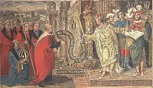
The Selsey area, is traditionally the most popular candidate for Cymenshore. The tradition is based largely on two charters that refer to a place with a similar name in the boundary clause to that cited in the Anglo-Saxon Chronicle.[18][19][20]The charter that defined the land award to Wilfrid at Selsey, in the 7th century, by King Caedwalla is actually a 10th-century forgery.[18] The relevant section of the forged charter, says (in Latin):
Ab introitu portus qui appellatur Anglice Wyderinges, post retractum mare in Cumeneshore, sic uersus occidentalem plagam iuxta mare usque Rumbruge, ...
and the translation is:
from the entrance of the harbour which is called in English Wyderinges round where the sea falls back at Cumenshore then towards the western shore at Rumbruge ...
A further source is from the Charter of Byrhthelm (presumably Brihthelm (Bishop of Selsey)), which is believed to be genuine and is to do with some land that had been seized from the See of Selsey, it confirms that the boundary is from Wytherings Mouth[lower-alpha 9] and Cymenshoran in the east to Hormouth in the west:
Þis sinde þat land gemeare to Selesie. Arest æt Wedering muðe, þa be sæ on Cymeneres horan, swa west be sæ oð Ðribeorgas, forð be stronde to cwuenstane 7 forð be strande on Horemuðen..
These are the land-boundaries of Selsey, firstly at Withering,[lower-alpha 9] thence by sea to the Owers, west by sea to Rumbridge; on by beach to queen's stone and on by beach to Hormouth..
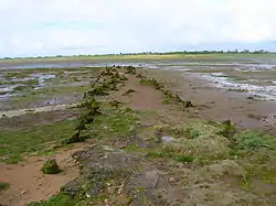
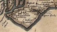
Rumbruge/ Rumbridge (alias "thri beorg" – three barrows, now the Medmerry Bank) is believed to have been an islet and trading port off the southwest coast of the Manhood Peninsula, that has long since succumbed to the sea and Wytherings mouth was part of what is now Pagham Harbour.[22][23][lower-alpha 10]
The Owers
Just off the tip of Selsey Bill, to approximately11 kilometres (6.8 mi) SSE, are groups of ledges and rocks known as the Owers. [lower-alpha 11][25]
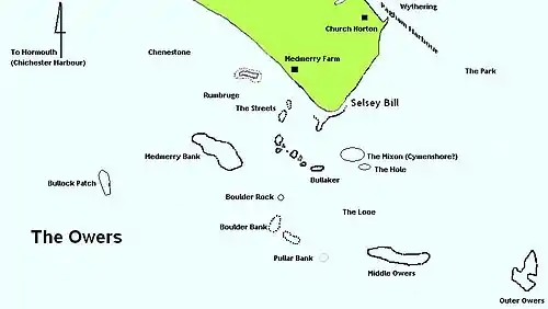
Outer and Middle Owers
Some historians such as Hunter-Blair identify the Outer Owers and Middle Owers as the landing place for Ælle.[19]However this is problematical as according to SCOPAC[lower-alpha 12] the coastal erosion pattern means that this section of the Owers would not have been part of the shoreline for at least 5000 years. The Outer Owers are approximately 11 kilometres (6.8 mi) off Selsey Bill and the erosion pattern suggests that the shore would have been 2–3 km seaward 5000 years ago.[27][26]
The Mixon
To the south of Selsey Bill lies the Mixon rocks.[27]
It is believed that, in the Iron Age, the Atrebates (one of the Belgae tribes) built their Oppidum in the Selsey area and Richardson speculates that the Mixon could be the site of Cidade Celha (the Old City) and therefore Cymensora.[29][lower-alpha 14][31][32]
The archaeological evidence demonstrates that the Mixon would have been the shoreline during the Roman occupation, with it not being breached by the sea until the 10th or 11th century.[33][lower-alpha 15][lower-alpha 16][lower-alpha 17] As late as the 17th century, it was reported that the remains of the "ancient little city" could be seen at low tide.[28]
Keynor
The Manor of Keynor is situated at the western end of Pagham Harbour.[35] Selsey-based historians Edward Heron-Allen and Francis Mee favour the Keynor area of Sidlesham for Cymenshore; they suggest that the name Keynor is derived from Cymensora.[36][37] However Margaret Gelling asserts that Keyn-or actually means Cow-Shore in Old English.[38]
Pagham Harbour
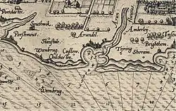
Pagham Harbour currently is a nature reserve, however in earlier times was a working harbour with three ports, one at the western end at Sidlesham Mill known as Wardur, one at the other at the entrance to the harbour and known as Charlton and one on the Pagham side known as the Port of Wythering (Wyderinges).[39][40] The port of Wardur was part of 'New Haven' a development in the Middle Ages.[35] The Port of Wythering was overrun by the sea in the 13th century and the whole harbour eventually silted up and ceased to be navigable, except for small craft.[21]
West Wittering
West Wittering has been cited by some early cartographers and historians as the site for Cymenshore. For example in his Britannia Camden said:
Cissa: who beeing of the Saxons line the second king of this pety kingdom, after his father Aella, accompanied with his brother Cimen and no small power of the Saxons, at this shore arrived and landed at Cimonshore, a place so called of the said Cimen, which now hath lost the name; but that it was neere unto Wittering, the charter of the donation which King Cedwalla made unto the Church of Selsey most evidently prooveth. Another fort likewise two miles from Cisiburie is to be seene, which they used to call Chenkburie.
Also Morden's map of 1695 shows Cimenshore being adjacent to the Witterings.
However, other historians have posited that siting Cymenshore off West Wittering as mistaken and was probably due to a mistranslation of the charter.[41] The charter itself, in the original early English describes part of the boundary of the land as .. Wedering muðe.. (Wedering mouth).[42] Wedering was the port of Withering a village, now lost, at the entrance to what is now Pagham Harbour. It is possible that earlier historians had translated Wedering incorrectly, as Wittering.[41][43]
Other possible locations
Ouse-Cuckmere
Welch believes that the location for Cymenshore is more likely to be in the Ouse-Cuckmere area of East Sussex, his reasoning is that there is no archaeological evidence to support a landing at Selsey.[12] However Richardson states that the place names with the Old English ora element of Cymensora are very common along the Hampshire and West Sussex coastline but not around the Ouse-Cuckmere area.[44] There is also a suggestion that the archaeology off the Selsey coast has just not been fully realised yet.[lower-alpha 18]
Shoreham
Shoreham has also been cited as a possible location, for example in 1906 Hilaire Belloc in his Hills and the Sea when discussing St Wilfrid he said:
But those memories were getting worse and worse, for it was nearly two hundred years since the ships of Ælle had sailed into Shoreham, which showed him to be a man of immense determination, for it is a most difficult harbour, and there were then no piers and lights – it was nearly two hundred years, and there was only the least little glimmering twilight left of the old day.
See also
Notes
- Also: Cymensora, Cumeneshore, Cumenshore, Cimeneres horan, Cymeneres horan[1]
- ASC 477 - Her cuom Ęlle on Bretenlond 7 his .iii. suna, Cymen 7 Wlencing 7 Cissa, mid .iii. scipum on þa stowe þe is nemned Cymenesora, 7 þær ofslogon monige Wealas 7 sume on fleame bedrifon on þone wudu þe is genemned Andredesleage.[2]
- The account marks the beginning of Saxon Sussex.[4]
- ASC 485."Her Ęlle gefeaht wiþ Walas neah Mearcrędesburnan stęðe."
- ASC491-Her Ęlle 7 Cissa ymbsæton Andredescester 7 ofslogon alle þa þe þærinne eardedon; ne wearþ þær forþon an Bret to lafe. [2]
- According to Morris Gildas had misplaced in his narrative his one datable event. Bede had failed to spot that the date was 20 years out, and it is Bede's date that the Anglo-Saxon Chronicle follows.[8]
- Six Anglo-Saxon cemeteries provide the bulk of the archaeological evidence for the early period; these are Highdown, near Worthing, and the group between the rivers Ouse and Cuckmere: Alfriston, Selmeston, South Malling Beddingham and Bishopstone. They all seem to have been of moderate size: those which have been fairly fully excavated are Highdown, with over 170 graves; Alfriston, 150-160; and Bishopstone, 118. Inhumation was the predominant rite in each case, but a proportion of cremations was present at Highdown (about. 28) and Bishopstone (6).[4]
- An excavation locally discovered 282 cremations and inhumations.[10]
- The Port of Wythering was a settlement at the mouth of what is now Pagham Harbour. It was overrun by the sea in the 13th century and Pagham Harbour eventually silted up and ceased to be navigable, except for small craft.[21]
- The starting place was 'three barrows' (thri, beorg), which gave rise to the lost placename Rumbridge, thought to be between Medmerry and Wittering."[24]
- The modern distances were based on the location of Selsey Bill being 50° 43′ 21.62″ N, 0° 47′ 16.77″ W, Outer Owers Light Beacon 50º38.59N 0º41.09W
- The Standing Conference on Problems Associated with the Coastline (SCOPAC) was established in 1986 and consists of local authorities, the Environment agency and others.[26]
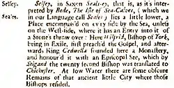
- In this Isle there are some ob∣scure remains of that ancient little city, in which those Bishops resided, cover'd at high water, but plainly visible at low water -William Camden.[28]
- The main oppidum of this shrunken kingdom was probably at Selsey.[30]
- "A Roman wall, a quarry, a standing stone and a presumed Roman lighthouse have all been reported by divers in the vicinity of the Mixon rock."[26]
- Ruins of an old Roman fort and also ballista ammunition have been found at the site.[34]
- "Barrier breaching and shoreline recession associated with rising sea-level and storm events caused The Mixon to become an offshore bank, or shoal, probably at about 950–1050."[26]
- "There is a rich, only partially explored, offshore archaeological legacy of submerged Romano-British, Saxon and early medieval landscape features, partially recorded in documentary and archival records." [45]
Citations
- Kelly 1998, p. 12,118.
- Jebson 2006.
- Richardson 2000, pp. 66-73.
- Bell 1978, pp. 64-69.
- Bately 1986, pp. vii-ix.
- Jones 1998, p. 71.
- Gildas 1848.
- Morris 1965, pp. 145-185.
- Welch 1978, pp. 23-25.
- Down & Welch 1990, p. 9.
- Welch 1971, pp. 232-237.
- Welch 1978, pp. 23-24.
- Richardson 2000, p. 57.
- Gelling 2000, pp. 179-180.
- Gelling 2000, p. 275.
- Welch 1992, p. 9.
- Richardson 2000, pp. 63–65.
- Kelly 1998, pp. 3-13.
- Hunter-Blair 1963, p. 176.
- Gelling & Cole 2000, pp. 199-210.
- Salzman 1953, pp. 227-233.
- Wallace 1996, p. 12.
- Richardson 2000, pp. 64–65,93.
- Kelly 1998, p. 76.
- Cunliffe 2000, p. 12.
- SCOPAC 1986.
- United Kingdom Hydrographic Office 2004.
- Camden 1701, p. 228.
- Richardson 2000, p. 64.
- Down 1978, p. 52.
- Richardson 2000, pp. 65-76.
- Stenton 1971, pp. 17–18.
- Hampshire & Wight Trust for Maritime Archaeology 2006, p. 132.
- Wallace 1968, pp. 136-145.
- Salzman, L.F. 1953, pp. 210–215.
- Heron-Allen 1911, p. 88.
- Mee 1988, p. 10.
- Gelling & Cole 2000, pp. 208–209.
- Salzman 1935, pp. 100-102.
- Salzman, Louis Francis 1953, pp. 205-210.
- Heron-Allen, pp. 88-89.
- Kelly 1998, pp. 85-91.
- National Archive 1135.
- Richardson 2000, pp. 58–59.
- Carter & Bray 2003.
References
- Barker, Eric E. (1949). Salzman, L.F. (ed.). "Anglo Saxon Charters". Sussex Archaeological Collections. Sussex Archaeological Society. 88.CS1 maint: ref=harv (link)
- Bately, J.M., ed. (1986). The Anglo-Saxon Chronicle. Cambridge: D.D.Brewer. ISBN 978-0-85991-103-0.CS1 maint: ref=harv (link)
- Bell, Martin (1978). "Saxon Sussex. In Drewett, P. L. (ed.), Archaeology in Sussex to AD 1500 : essays for Eric Holden". Cite journal requires
|journal=(help)CS1 maint: ref=harv (link) - Belloc, Hillaire (1996). The Hills and the Sea (reprint ed.). Marlborough. ISBN 0-8101-6009-9.CS1 maint: ref=harv (link)
- Camden, William (1701). Brittannia Vol 1 Updated English version. London: Joseph Wild.CS1 maint: ref=harv (link)
- Carter, Dave; Bray, Malcom (2003). "Sediment Transport Study East Head to Pagham Harbour. Section 1.1". SCOPAC. Archived from the original on February 24, 2013. Retrieved 20 October 2010.CS1 maint: ref=harv (link)
- Cunliffe, Tom (2000). The Shell Channel Pilot, The South Coast of England and North Coast of France (3rd ed.). Cambridgeshire: Imray. ISBN 978-0-85288-421-8.CS1 maint: ref=harv (link)
- Down, Alec; Welch, Martin (1990). Chichester Excavations 7: Apple Down & the Mardens. Chichester District Council. ISBN 0-85017-002-8.CS1 maint: ref=harv (link)
- Down, Alec (1978). Peter Drewett (ed.). Archaeology in Sussex to A.D.1500 (Research reports / Council for British Archaeology):Roman Sussex-Chichester and the Chilgrove Valley. London: Council for British Archaeology. ISBN 0-900312-67-X.CS1 maint: ref=harv (link)
- Gelling, Margeret (2000). Place-Names in the Landscape. London: Phoenix. ISBN 1-84212-264-9.CS1 maint: ref=harv (link)
- Gelling, Margaret; Cole, Anne (2000). The Landscape of Place-Names. Stamford: Tyas. ISBN 1-900289-26-1.CS1 maint: ref=harv (link)
- Gildas (1848). "23".
 The Ruin of Britain. Translated by Habington; Giles, J.A.CS1 maint: ref=harv (link)
 - Hampshire & Wight Trust for Maritime Archaeology (2006). "SCOPAC Research Project — Archaeology & Coastal Change: Project Report". Southampton: SCOPAC. Cite journal requires
|journal=(help)CS1 maint: ref=harv (link) - Heron-Allen, Edward (1911). Selsey Bill. Historic and Prehistoric. London: Duckworth. OCLC 14065805.CS1 maint: ref=harv (link)
- Hunter-Blair, Peter (1963). Roman Britain and Early England. Norton. ISBN 0-19-821716-1.CS1 maint: ref=harv (link)
- Jebson, Tony (2006). "Anglo Saxon Chronicle. Manuscript A:The Parker Chronicle". Retrieved 27 December 2009.CS1 maint: ref=harv (link)
- Jones, Michael E. (1998). The End of Roman Britain. Ithaca, NY: Cornell University Press. ISBN 978-0-8014-8530-5.CS1 maint: ref=harv (link)
- Kelly, S. E (1998). Anglo-Saxon Charters VI, Charters of Selsey. OUP for the British Academy. ISBN 0-19-726175-2.CS1 maint: ref=harv (link)
- Mee, Frances (1988). A History of Selsey. Chichester, Sussex: Philimore. ISBN 0-85033-672-4.CS1 maint: ref=harv (link)
- Morris, John (1965). Jarrett and Dobson (ed.). Britain and Rome : Dark Age Dates: Essays presented to Eric Birley on his 60th Birthday. Kendal.CS1 maint: ref=harv (link)
- National Archive (1135). "Charter Granted by King Henry II at Westminster". Kew: The National Archives. Retrieved 2 May 2020.CS1 maint: ref=harv (link)
- Richardson, W.A.R. (2000). Watts, Victor (ed.). "The Owers". The English Placename Society Journal 33. ISSN 1351-3095.CS1 maint: ref=harv (link)
- Salzman, L.F. (1953). Pagham. A History of the County of Sussex. 4. pp. 227–233. Retrieved 14 April 2020.CS1 maint: ref=harv (link)
- Salzman, L.F. (1953). Sidlesham. A Victorian History of the County of Sussex. 4. London. pp. 210–215. Retrieved 17 April 2020.CS1 maint: ref=harv (link)
- Salzman, Louis Francis (1935). The City of Chichester: The port. A Victorian History of the County of Sussex. 3. London. pp. 100–102. Retrieved 17 April 2020.CS1 maint: ref=harv (link)
- Salzman, Louis Francis (1953). Selsey. A Victorian History of the County of Sussex. 4. London. pp. 205–210. Retrieved 17 April 2020.CS1 maint: ref=harv (link)
- SCOPAC (1986). "Standing Conference on Problems Associated with the Coastline". SCOPAC. Retrieved 14 February 2020.CS1 maint: ref=harv (link)
- Stenton, Frank (1971). Anglo Saxon England (3rd ed.). London: OUP. ISBN 978-0-19-280139-5.CS1 maint: ref=harv (link)
- United Kingdom Hydrographic Office (2004). (SC1652) Selsey Bill to Beachy Head (Map). United Kingdom Hydrographic Office. ISBN 1-84579-317-X.CS1 maint: ref=harv (link)
- Wallace, Hume (1996). Sealevel and Shoreline between Portsmouth and Pagham for the past 2500 years. Part 2. Published by the Author.CS1 maint: ref=harv (link)
- Wallace, Hume (1968). Kendall McDonald (ed.). The Underwater Book: The Search For Roman Selsey. London: Pelham for BSAC. OCLC 465833.CS1 maint: ref=harv (link)
- Welch, M. G. (1992). Anglo-Saxon England. English Heritage. ISBN 0-7134-6566-2.CS1 maint: ref=harv (link)
- Welch, M. G. (1971). "Late Romans and Saxons in Sussex". Britannia. The Society for the Promotion of Roman Studies. 2: 232–237. doi:10.2307/525813.CS1 maint: ref=harv (link)
- Welch, M.G. (1978). "Early South Saxons". In Brandon, Peter (ed.). The South Saxons. Chichester: Phillimore. ISBN 0-85033-240-0.CS1 maint: ref=harv (link)
External links
- Sidlesham Parish Site - Information on how to find Keynor - Note Keynor Lane on map and Earnley (suggested area for Rumbruge) immediately to the west.
- St Thomas a Becket - Parish Church at the East end of Pagham Harbour near to Wythering. St Wilfrid gave Pagham to the Archbishops of Canterbury when he left Selsey, and they are still the patrons of this church. A Saxon burial urn was found near to the church in the 1950s and now is on display in the south aisle.
- Movable Type Scripts - Useful site for calculating distances based on the latitude/ longitude bearings. It will also provide a map of the locations. You can use this to calculate the distances between Selsey Bill and the various Owers rocks.
- Online translation of the 1607 edition of Camden's Britannia- See section 4. of the Sussex pages for description of Selsey.