Cypress Peak
Cypress Peak is a mountain peak south of Brandywine Mountain on the Squamish-Cheakamus divide, west of Whistler in the New Westminster Land District of British Columbia, Canada. The mountain was named after nearby Cypress Creek (which has since been renamed Roe Creek).[2]
| Cypress Peak | |
|---|---|
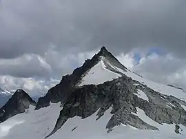 Cypress Peak, July 2005 | |
| Highest point | |
| Elevation | 2,083 m (6,834 ft) [1] |
| Prominence | 265 m (869 ft) [1] |
| Coordinates | 50°02′08″N 123°15′11″W [2] |
| Geography | |
 Cypress Peak British Columbia, Canada | |
| Parent range | Pacific Ranges |
| Topo map | NTS 092/J03 |
Climate
Based on the Köppen climate classification, Cypress Peak is located in the marine west coast climate zone of western North America.[3] Most weather fronts originate in the Pacific Ocean, and travel east toward the Coast Mountains where they are forced upward by the range (Orographic lift), causing them to drop their moisture in the form of rain or snowfall. As a result, the Coast Mountains experience high precipitation, especially during the winter months in the form of snowfall. Temperatures can drop below −20 °C with wind chill factors below −30 °C. The months July through September offer the most favorable weather for climbing Cypress Peak.

References
- "Cypress Peak". Bivouac.com. Retrieved 2010-12-29.
- "Cypress Peak". BC Geographical Names. Retrieved 2010-12-29.
- Peel, M. C.; Finlayson, B. L. & McMahon, T. A. (2007). "Updated world map of the Köppen−Geiger climate classification". Hydrol. Earth Syst. Sci. 11. ISSN 1027-5606.