Dùn da Ghaoithe
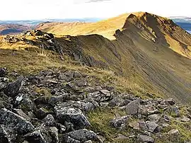
Dùn da Ghaoithe (Scottish Gaelic: Dùn da Ghaoithe, meaning "fort of the two winds") is the second highest mountain on the Isle of Mull, western Scotland, and the island's only Corbett.[1] It reaches 766 metres (2,513 ft) high, but "its long ridge and deep corries make it seem far higher".[2] It boasts sea views "in almost every direction",[2] and is the main mountain seen by visitors to the island on leaving the Caledonian MacBrayne ferry from Oban at Craignure.[1]
| Dùn da Ghaoithe | |
|---|---|
 | |
| Highest point | |
| Elevation | 766 m (2,513 ft) |
| Prominence | 659 m (2,162 ft) |
| Parent peak | Ben More (Mull) |
| Listing | Corbett, Marilyn |
| Coordinates | 56°27′38″N 5°46′47″W |
| Naming | |
| Pronunciation | Scottish Gaelic: [ˈt̪uːn ˈt̪aː ˈɣɤjə] |
| Geography | |
| Location | Argyll and Bute, Scotland |
| OS grid | NM672362 |
| Topo map | OS Landranger 49 |
References
- Terry Marsh (2011). "Walk 2.14. Dùn da Ghaoithe". The Isle of Mull. British Hills Series. Cicerone Press. pp. 130–135. ISBN 978-1-85284-595-7.
- Kirstie Shirra (2010). "39. Dun da Ghaoithe (766 m)". Scotland's Best Small Mountains. Cicerone Press. pp. 223–227. ISBN 978-1-85284-578-0.
This article is issued from Wikipedia. The text is licensed under Creative Commons - Attribution - Sharealike. Additional terms may apply for the media files.