Deer Creek Dam and Reservoir
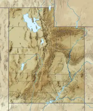
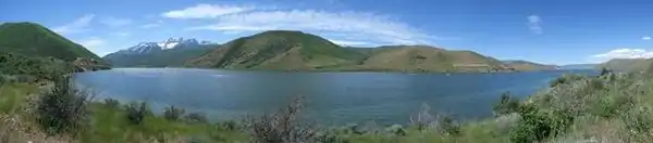
The Deer Creek Dam and Reservoir hydroelectric facilities are on the Provo River in western Wasatch County, Utah, United States,[1][2] about 16 miles (26 km) northeast of Provo. The dam is a zoned earthfill structure 235 feet (72 m) high with a crest length of 1,304 ft (397 m). The dam contains 2,810,000 cubic yards (2,150,000 m³) of material and forms a reservoir of 152,570 acre foot (188,190,000 m3) capacity. Construction began in May 1938 and was completed in 1941. The reservoir supplies water for agricultural, municipal and industrial use. Recreational activities on and around the reservoir include boating, fishing, camping, swimming and water skiing.
| Deer Creek Reservoir | |
|---|---|
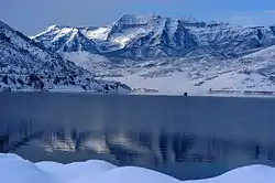 | |
 Deer Creek Reservoir  Deer Creek Reservoir | |
| Location | Wasatch County, Utah |
| Coordinates | 40°24′24″N 111°31′37″W |
| Type | reservoir |
| Primary inflows | Provo River |
| Primary outflows | Provo River |
| Catchment area | 1,870 km2 (720 sq mi) |
| Basin countries | United States |
| Max. length | 9.1 km (5.7 mi) |
| Max. width | 1.8 km (1.1 mi) |
| Surface area | 12 km2 (4.6 sq mi) |
| Water volume | 1 km (0.62 mi) |
| Residence time | 1.3 year |
| Shore length1 | 1 km (0.62 mi) |
| Surface elevation | 1,651 m (5,417 ft) |
| Islands | 1 |
| Settlements | 1 |
| 1 Shore length is not a well-defined measure. | |
The Deer Creek Dam is the key structure of the Provo River Project managed by the U.S. Department of the Interior Bureau of Reclamation.
Deer Creek Reservoir is the main feature of Deer Creek State Park.
Deer Creek is home to several fish species, including Largemouth and Smallmouth Bass, Rainbow Trout, Brown Trout, Yellow Perch, Walleye and Common Carp.
References
External links
| Wikimedia Commons has media related to Deer Creek Reservoir. |
| Wikimedia Commons has media related to Deer Creek Dam. |
- "Provo River Project". Retrieved Jan. 10, 2006.
- "Report on Deer Creek Reservoir" (PDF). (336 KiB) by the Utah Division of Water Quality
- Deer Creek Reservoir - UtahDiving.com
- Historic American Engineering Record (HAER) No. UT-93, "Deer Creek Dam, Spanning the Provo River at the intersection of U.S. Highway 189 & Deer Creek Reservoir, Charleston, Wasatch County, UT", 20 photos, 1 measured drawing, 24 data pages, 6 photo caption pages
- HAER No. UT-93-A, "Dam", 8 photos, 10 data pages, 3 photo caption pages
- HAER No. UT-93-B, "Hydroelectric Powerplant", 2 photos, 4 data pages, 2 photo caption pages
- HAER No. UT-93-D, "Tailrace and Tailrace Regulating Gates", 1 photo, 4 data pages, 2 photo caption pages
- HAER No. UT-93-F, "Chlorination Building", 1 photo, 4 data pages, 2 photo caption pages
- Historic American Buildings Survey (HABS) No. UT-137, "Deer Creek Dam, CCC Government Camp, West side of U.S. Highway 189, north of railroad overpass and 2,000 feet southwest of Deer Creek Dam, Charleston, Wasatch County, UT", 10 photos, 1 measured drawing, 7 data pages, 6 photo caption pages
- HABS No. UT-137-A, "Brick Residence No. 1", 1 photo, 4 data pages, 2 photo caption pages
- HABS No. UT-137-B, "Brick Residence No. 2", 2 photos, 4 data pages, 2 photo caption pages
- HABS No. UT-137-C, "Frame Residence", 2 photos, 4 data pages, 2 photo caption pages
- HABS No. UT-137-D, "Garage", 1 photo, 4 data pages, 2 photo caption pages
- HABS No. UT-137-E, "Barn", 1 photo, 4 data pages, 2 photo caption pages
- HABS No. UT-137-F, "Pumphouse", 1 photo, 4 data pages, 2 photo caption pages
- HABS No. UT-137-G, "Chicken Coop", 1 photo, 4 data pages, 2 photo caption pages
- HABS No. UT-137-J, "Animal Shed Ruin", 1 photo, 4 data pages, 2 photo caption pages
- HABS No. UT-137-K, "Stone Oven", 2 photos, 4 data pages, 2 photo caption pages
- HABS No. UT-137-L, "Animal Shed", 2 photos, 4 data pages, 2 photo caption pages
- HABS No. UT-137-M, "Animal-Tractor Shed", 1 photo, 4 data pages, 2 photo caption pages
| Authority control |
|---|