Delaware Route 11
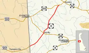
Delaware Route 11 (DE 11) is a state highway in Kent County, Delaware. It runs from Maryland Route 302 (MD 302) at the Maryland border near Templeville, Maryland northeast to DE 300 near Kenton. The road, known as Arthursville Road for its entire length, passes through the farmland of western Kent County and through the town of Hartly, where it intersects DE 44. The route was built as a state highway in the 1920s and 1930s and received the DE 11 designation by 1936.
| ||||
|---|---|---|---|---|
| Arthursville Road | ||||
 | ||||
| Route information | ||||
| Maintained by DelDOT | ||||
| Length | 6.93 mi[1] (11.15 km) | |||
| Existed | 1936[2]–present | |||
| Major junctions | ||||
| South end | ||||
| North end | ||||
| Location | ||||
| Counties | Kent | |||
| Highway system | ||||
| ||||

Route description
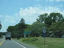
DE 11 begins at the Maryland border in western Kent County, where the road continues west into that state as MD 302 towards the town of Templeville. From the state line, DE 11 heads northeast on two-lane, undivided Arthursville Road through a mix of woods and farms, with occasional residences. The road enters the town of Hartly, where it passes several homes along with some commercial establishments. In the center of town, the route crosses DE 44 and heads north before it curves northeast out of Hartly. DE 11 continues into rural areas, making another turn north. The road runs northeast and crosses Jordan Branch and Pinks Branch before it comes to an end at DE 300 to the southwest of the town of Kenton.[3][4]
DE 11 has an annual average daily traffic count ranging from a high of 2,543 vehicles at the eastern terminus at the north end of Hartly to a low of 1,503 vehicles at the south end of Hartly.[1] None of DE 11 is part of the National Highway System.[5]
History
By 1920 what is now DE 11 existed as an unimproved county road.[6][7] The portion of the route north of Hartly was built as a paved state highway in 1927.[8] The road south of Hartly was taken over by the state and paved by 1931.[9] DE 11 was assigned to its current alignment by 1936.[2] The route has not changed since its inception.[3]
Major intersections
The entire route is in Kent County.
| Location | mi[1] | km | Destinations | Notes | |
|---|---|---|---|---|---|
| | 0.00 | 0.00 | Maryland state line; southern terminus | ||
| Hartly | 2.58 | 4.15 | |||
| | 6.93 | 11.15 | Northern terminus | ||
| 1.000 mi = 1.609 km; 1.000 km = 0.621 mi | |||||
See also
 U.S. Roads portal
References
- Staff (2018). "Traffic Count and Mileage Report: Interstate, Delaware, and US Routes" (PDF). Delaware Department of Transportation. Retrieved March 29, 2020.
- Delaware State Highway Department; The National Survey Co. (1936). Official Road Map of the State of Delaware (PDF) (Map) (1936–1937 ed.). Dover: Delaware State Highway Department. Retrieved November 24, 2015.
- Delaware Department of Transportation (2017). Official Travel & Transportation Map (PDF) (Map). Dover: Delaware Department of Transportation. Retrieved August 18, 2019.
- Google (March 17, 2010). "overview of Delaware Route 11" (Map). Google Maps. Google. Retrieved March 17, 2010.
- National Highway System: Delaware (PDF) (Map). Federal Highway Administration. 2010. Retrieved February 10, 2012.
- Delaware State Highway Department (1920). Official Road Map (PDF) (Map). Dover: Delaware State Highway Department. Retrieved November 24, 2015.
- Delaware State Highway Department (1924). Official Road Map (PDF) (Map). Dover: Delaware State Highway Department. Retrieved November 24, 2015.
- "Annual Report of the State Highway Department" (PDF) (1927 ed.). Dover, Delaware: Delaware State Highway Department. December 31, 1927: 17. Retrieved November 16, 2014. Cite journal requires
|journal=(help) - Delaware State Highway Department (1931). Official Road Map of the State of Delaware (PDF) (Map). Dover: Delaware State Highway Department. Retrieved November 24, 2015.