Denier, Pas-de-Calais
Denier is a commune in the Pas-de-Calais département in the Hauts-de-France region of France.
Denier | |
|---|---|
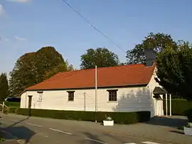 The church of Denier | |
 Coat of arms | |
Location of Denier 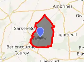
| |
 Denier  Denier | |
| Coordinates: 50°17′19″N 2°26′41″E | |
| Country | France |
| Region | Hauts-de-France |
| Department | Pas-de-Calais |
| Arrondissement | Arras |
| Canton | Avesnes-le-Comte |
| Intercommunality | CC Campagnes de l'Artois |
| Government | |
| • Mayor (2008–2014) | Jean Bridel |
| Area 1 | 3.1 km2 (1.2 sq mi) |
| Population (2017-01-01)[1] | 86 |
| • Density | 28/km2 (72/sq mi) |
| Time zone | UTC+01:00 (CET) |
| • Summer (DST) | UTC+02:00 (CEST) |
| INSEE/Postal code | 62266 /62810 |
| Elevation | 98–146 m (322–479 ft) (avg. 126 m or 413 ft) |
| 1 French Land Register data, which excludes lakes, ponds, glaciers > 1 km2 (0.386 sq mi or 247 acres) and river estuaries. | |
Geography
A small farming village 16 miles (25.7 km) west of Arras at the junction of the D81 and D79E roads.
Population
| Year | 1962 | 1968 | 1975 | 1982 | 1990 | 1999 |
|---|---|---|---|---|---|---|
| Population | 105 | 110 | 88 | 74 | 61 | 58 |
| From the year 1962 on: No double counting—residents of multiple communes (e.g. students and military personnel) are counted only once. | ||||||
Places of interest
- The chapel of St. Therese.
Notes
- "Populations légales 2017". INSEE. Retrieved 6 January 2020.
- This article is based on the equivalent article from the French Wikipedia, consulted 13 June 2008.
External links
| Wikimedia Commons has media related to Denier (Pas-de-Calais). |
- Denier on the Quid website (in French)
| Authority control |
|---|
This article is issued from Wikipedia. The text is licensed under Creative Commons - Attribution - Sharealike. Additional terms may apply for the media files.