Deschutes River (Washington)
The Deschutes River is a 50-mile-long (80 km) river in the U.S. state of Washington. Its source is in the Gifford Pinchot National Forest in Lewis County, and it empties into Budd Inlet of Puget Sound at Olympia in Thurston County. It was given its name by French fur traders, who called it Rivière des Chutes, or "River of the Falls", a translation of the First Nations name for the site. (The city of Tumwater, founded in the same location, takes its name from the Chinook Jargon translation for "waterfall".)
| Deschutes River | |
|---|---|
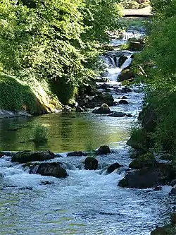 Tumwater Falls of the Deschutes River, in the city of Tumwater | |
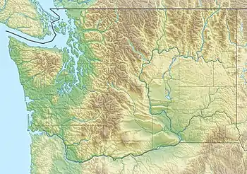 Location of the mouth of the Deschutes River in Washington  Deschutes River (Washington) (the United States) | |
| Location | |
| Country | United States |
| State | Washington |
| County | Thurston, Lewis |
| Physical characteristics | |
| Source | Cascade Range |
| • coordinates | 46°41′0″N 122°26′17″W[1] |
| Mouth | Puget Sound |
• coordinates | 47°1′6″N 122°54′13″W[1] |
| Length | 50 mi (80 km) |
| Basin size | 162 sq mi (420 km2)[2] |
| Discharge | |
| • location | river mile 2.4 at Tumwater[2] |
| • average | 396 cu ft/s (11.2 m3/s)[2] |
| • minimum | 48 cu ft/s (1.4 m3/s) |
| • maximum | 8,150 cu ft/s (231 m3/s) |
Tributaries of the river include Spurgeon Creek, Thurston Creek and Lake Lawrence.[3] There are numerous parks along its course, including Pioneer Park and Tumwater Falls Park. A popular tubing stretch runs from Pioneer Park to Tumwater Falls.
See also
References
- U.S. Geological Survey Geographic Names Information System: Deschutes River
- "Water Resources Data-Washington Water Year 2005; Deschutes and Nisqually River Basins; 12080010 Deschutes River at E Street Bridge, at Tumwater, WA" (PDF). United States Geological Survey. Retrieved 2009-06-01.
- East Olympia, Vail, and Lake Lawrence, Washington 7.5 Minute Topographic Quadrangles, USGS, 1959
| Authority control |
|
|---|