Devil's Point, Devon
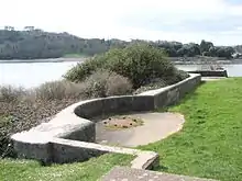
Devil's Point (also called Western King Point) is located on the eastern side of the mouth of the River Tamar where it meets the English Channel at Plymouth Sound.[1][2]
.jpg.webp)
Geography
The Point marks the southwest extremity of East Stonehouse in Plymouth, England. On the opposite western shore of the Tamar is Mount Edgcumbe Country Park. To the immediate north is the Royal William Victualling Yard.
The area is a public park [3] and has a wealth of historical features. For centuries Devil's Point been used by friends and family to wave goodbye or welcome home to the crews of Royal Navy warships [4] as they transit the narrow waters adjacent to Devil's Point.
Military history
Also located at Devil's Point is Devil's Point Battery which was built between 1901 and 1902. It was armed with two 12–pounder Quick Firing guns. Both had been removed by 1936, but the positions remain today.[5]
References
- "Devon - In Pictures - Devil's Point". BBC. 2005-08-22. Retrieved 2012-01-06.
- "Devils Point, Plymouth, Devon". Devon-explorer.co.uk. Retrieved 2012-01-06.
- Jeremy Sabel. "Plymouth City Council - Devils Point County Wildlife Site". Plymouth.gov.uk. Retrieved 2012-01-06.
- "Ministry of Defence | Defence News | Military Operations | HMS Cumberland sails for the Gulf". Mod.uk. 2007-02-20. Retrieved 2012-01-06.
- The National Archives WO78/5054, Maps and Plans, Plymouth and Falmouth Area: Devil's Point Battery, 1905
External links
| Wikimedia Commons has media related to Devil's Point, Devon. |