Dieng Plateau
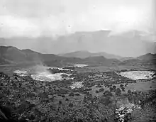
Dieng Plateau is a marshy plateau that forms the floor of a caldera complex on the Dieng Volcanic Complex in Wonosobo and Banjarnegara, Central Java, Indonesia.[1] Referred to as "Dieng" by Indonesians, it sits at 2,000 metres (6,600 ft) above sea level, far from major population centres. The name "Dieng" comes from Di Hyang which means "Abode of the Gods".[2]
Part of General Sudirman's guerrilla campaign during the Indonesian War of Independence took place in the area.
Temples
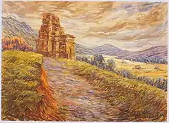
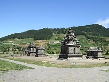
The Plateau is the location of eight small Hindu temples from the Kalingga Kingdom.[3]:79,90 It is unclear when they were built, estimated to range from mid 7th century to end of 8th century AD; they are the oldest known standing stone structures in Java.[4] They are originally thought to have numbered 400 but only eight remain. The temples are now believed to have been named after the heroes of the Hindu epic Mahabharata.[5]
Michell claims Dieng's misty location almost 2,093 m above sea level, its poisonous effusions and sulphur-coloured lakes make it a particularly auspicious place for religious tribute. The temples are small shrines built as monuments to the god-ancestors and dedicated to Shiva.[6] The Hindu shrines are miniature cosmic mountains based on plans in Indian religious texts, although Schoppert suggest the design motifs have little connection to India.[7]
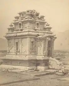
In 2011, in a review published by Romain,[4] the temple is now believed to be related to Dravida and Pallava style temples of South India. The theory that poisonous effusions make it auspicious is now disputed as volcanic activity in this area from 7th to 9th century is yet to established, and records suggest the temple was abandoned after volcanic eruptions became common in central Java.
Geography and climate
With an elevation of 2,060 m above sea level, Dieng has a distinct subtropical highland climate under the Köppen climate classification (Cwb). In its brief dry season (which is meteorologically aligned with the Southern Hemispherical winter season), there is much less rainfall than in its lengthy monsoon periods (lasting from October to May, also in line with the austral summer). The average annual temperature in Dieng is 14.0 °C. About 2652 mm of precipitation falls annually.
Known for its chilly climate, temperatures may even drop to 2 degrees (along with wind chills down to -2º) in the peak of its dry season. Though infrequent, frosts have been recorded every year, particularly in late evenings and mornings of July and August. This may last for one week in average. Though this regionally-rare weather phenomena occasionally attracts tourists to cluster around the plateau area,[8] it is also notorious for the destruction it often inflicts upon the local produce, with agricultural plants and crops such as potatoes being the most severely affected.
Locals usually call this frost "bun upas". On the local Javanese dialect, "Bun" (or "embun") means dew, while "upas" is poison. Although "bun upas" or frost in Dieng is actually not poisonous, this term "upas" was created by local people due to its devastating effect on agricultural plants, in which, the plants die quickly as if as they were poisoned when the frost takes place. The following climate data is for the village of Sembungan, which is one of the highest villages in Java.
| Climate data for Dieng (2062 m) | |||||||||||||
|---|---|---|---|---|---|---|---|---|---|---|---|---|---|
| Month | Jan | Feb | Mar | Apr | May | Jun | Jul | Aug | Sep | Oct | Nov | Dec | Year |
| Average high °C (°F) | 17.9 (64.2) |
18.5 (65.3) |
18.6 (65.5) |
18.4 (65.1) |
18.5 (65.3) |
18.5 (65.3) |
18.2 (64.8) |
18.0 (64.4) |
18.5 (65.3) |
18.8 (65.8) |
19.2 (66.6) |
18.8 (65.8) |
18.5 (65.3) |
| Daily mean °C (°F) | 13.9 (57.0) |
14.3 (57.7) |
14.4 (57.9) |
14.4 (57.9) |
14.3 (57.7) |
13.8 (56.8) |
13.2 (55.8) |
12.8 (55.0) |
13.6 (56.5) |
14.2 (57.6) |
14.7 (58.5) |
14.4 (57.9) |
14.0 (57.2) |
| Average low °C (°F) | 10.0 (50.0) |
10.1 (50.2) |
10.3 (50.5) |
10.4 (50.7) |
10.1 (50.2) |
9.2 (48.6) |
8.3 (46.9) |
7.6 (45.7) |
8.7 (47.7) |
9.6 (49.3) |
10.3 (50.5) |
10.1 (50.2) |
9.6 (49.2) |
| Average precipitation mm (inches) | 370 (14.6) |
430 (16.9) |
434 (17.1) |
249 (9.8) |
153 (6.0) |
83 (3.3) |
53 (2.1) |
35 (1.4) |
57 (2.2) |
170 (6.7) |
230 (9.1) |
388 (15.3) |
2,652 (104.5) |
| Source: [9] | |||||||||||||
Agriculture
The plateau is the largest producer of potatoes in Indonesia, with the crop becoming more predominant since 1985. Prior to this, various other crops such as corn and tobacco were planted instead. Expansion of potato plantations had for a time resulted in significant environmental damage from erosion and deforestration, though recent developments have seen a degree of reforestration.[10]
See also
Notes
- Suherdjoko (28 April 2006). "Dieng tidies itself up to regain past glory". The Jakarta Post. Archived from the original on 2 December 2013. Retrieved 4 April 2013.
- "Archived copy". Archived from the original on 2006-12-15. Retrieved 2006-11-25.CS1 maint: archived copy as title (link)
- Coedès, George (1968). Walter F. Vella (ed.). The Indianized States of Southeast Asia. trans.Susan Brown Cowing. University of Hawaii Press. ISBN 978-0-8248-0368-1.
- Romain, Julie (2011), "Indian Architecture in the 'Sanskrit Cosmopolis': The Temples of the Dieng Plateau", in Manguin, Pierre-Yves; Mani; Wade, Geoff (eds.), Early Interactions Between South and Southeast Asia: Reflections on Cross-cultural Exchange, 2, Singapore: Nalanda-Sriwijaya Centre. Institute of Southeast Asian Studies, pp. 299–316, ISBN 9789814345101
- Wright, A., & Smith, C. (2013). Volcanoes of Indonesia: Creators and Destroyers. Editions Didier Millet.
- Michell, George, (1977) The Hindu Temple: An Introduction to its Meaning and Forms". pp. 160-161. University of Chicago Press. ISBN 978-0-226-53230-1 /
- Schoppert, Peter (2012), Java Style, Editions Didier Millet, ISBN 9789814260602
- "Wisatawan Berburu Foto Embun Es di Dataran Tinggi Dieng". Liputan6. 31 July 2018. Retrieved 24 November 2018.
- http://en.climate-data.org/location/623617/
- "Dieng Plateau: from potatoes to cultural heritage". The Jakarta Post. 20 October 2015. Retrieved 30 October 2020.
References
| Wikivoyage has a travel guide for Dieng Plateau. |
| Wikimedia Commons has media related to Dieng Plateau. |
- Backshall, Stephan et al. (1999) Indonesia The Rough Guide London Penguin ISBN 1-85828-429-5 pp. 190–195
- Dalton, Bill Indonesia Handbook fourth edition pp. 280–283
- Dumarcay, J and Miksic J. Temples of the Dieng Plateau in Miksic, John 1996 (editor) 1996 Ancient History Volume 1 of Indonesian Heritage Series Archipelago Press, Singapore. ISBN 981-3018-26-7
- Mertadiwangsa, S. Adisarwono, (1999) Dataran tinggi Dieng : objek wisata alam dan objek wisata budayanya = Dieng Plateau Yogyakarta: Kaliwangi Offset Yogyakarta, (In Indonesian)
- Witton, Patrick (2003). Indonesia (7th ed.). Melbourne: Lonely Planet. pp. 209–211. ISBN 1-74059-154-2.