Dobongsan
Dobongsan is a mountain in Bukhansan National Park, South Korea.[1] It extends across Seoul, the national capital, and the cities of Yangju and Uijeongbu, in the province of Gyeonggi-do.[2] It has an elevation of 739.5 m (2,426 ft).[3] Nearby Dobongsan Station is named after it.[4]
| Dobongsan | |
|---|---|
%252C_Manjangbong_(718m)%252C_Jaunbong_(740m)_and_Shinseondae_(730m).JPG.webp) Mount Dobongsan peaks Seoninbong (708 m), Manjangbong (718 m), Jaunbong (740 m) and Shinseondae (730 m) taken from trail leading to summit.
 Dobongsan Location | |
| Highest point | |
| Elevation | 739.5 m (2,426 ft) |
| Coordinates | 37°41′54.73″N 127°0′53.88″E |
| Geography | |
| Location | South Korea |
| Climbing | |
| Easiest route | Dobongsan Station |
| Korean name | |
| Hangul | |
|---|---|
| Hanja | |
| Revised Romanization | Dobongsan |
| McCune–Reischauer | Tobongsan |
It is known for the magnificent rock formations of the Manjang-bong, Seonin-bong, Ju-bong, O-bong and Uiam-bong Peaks. The Seonin-bong summit has 37 hiking courses connecting to it, including the famous Bakjwi (Bat) Course. The mountain is also home to Cheonchuk-sa Buddhist Temple, the oldest temple in the region, and several other temples including Mangwol-sa, Wonhyo-sa and Hoeryong-sa, as well as a number of beautiful valleys called Donong, Songchu, Obong and Yeongeo-cheon. Furthermore, it is easily accessible by public transportation. [5]
Hiking course
Gallery
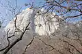 East face of Seoninbong Peak, Dobongsan taken from the trail leading to Manworam Temple.
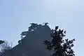 Observation area on a peak of Dobongsan.
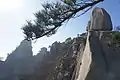 Rugged trail leading to peak of Dobongsan.
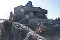 Wartime bunker on Dobongsan summit trail in Korea.
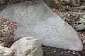 Petroglyph in stream bed at the foot of Dobongsan.
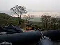 Temple on Dobongsan
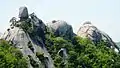 Obong
Obong
References
| Wikimedia Commons has media related to Dobongsan. |
- "Dobongsan Mountain". Visit Korea. Korea Tourism Organization. Retrieved 2015-09-16.
- "Bukhansan Dulle-gil Trail". Visit Korea. Korea Tourism Organization. Archived from the original on 2015-10-17. Retrieved 2015-09-16.
- Yu Jeong-yeol (2007). 한국의 산 여행 (Travel Guide to Korean Mountains). Seoul: 관동 상억연구회 (Kwandong). p. 47. ISBN 978-89-958055-1-0.
- "도봉산역" (in Korean). KRIC. Retrieved 2015-09-16.
- "Dobongsan Mountain (도봉산)" (in Korean). VisitKorea. Retrieved 2016-12-31.