Doki River
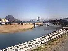
The Doki River (土器川 Dokigawa) is a Japanese stream that begins in the town of Mannō (Kagawa Prefecture, Nakatado District) within the Sanuki Mountains and ends in the city of Marugame. It is the only Class A river within Kagawa Prefecture. The river was named after Doki Village (土器村 Dokimura), which is presently known as the Doki vicinity or neighborhood within Marugame. Doki Village was located at the source of the river, and clay from there used to be made into earthenware goods (the Japanese word doki [土器] means "pottery" or "earthenware"). The central portion or the river is called haraikawa (祓川), which is a river in which worshippers purify themselves before praying.[1] The population around the river basin is around 35,000 people.
Geography
The source of the Doki River is located on Mt. Ryuo (town of Mannō, Katsuura vicinity) in the Sanuki Mountains. It flows north along Japan National Route 438 through the Marugame Plain until it reaches both the Northern Doki River and Fujimi Vicinities within Marugame, where it merges into the Seto Inland Sea. At times parts of the river dry up due to the dry climate in Kagawa and a man-made channel modification which shortened the river.
References
- 『われら土器川探検隊』、建設省四国地方建設局香川工事事務所、企画・発行 (Our Doki River Expedition Team, a children's book published by the Kagawa Construction Office within the Shikoku Construction Bureau, Ministry of Construction)
External links
- 土器川 - Shikoku Regional Development Bureau
- 日本河川協会
- A CASE STUDY OF THE DOKI RIVER, SOUTHWEST JAPAN (PDF)
This page is translated from the existing Japanese Wikipedia article 土器川