Dominican Republic–Haiti border
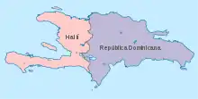
The Dominican Republic–Haiti border is the international boundary between the Dominican Republic (DR) and Haiti. The border is 376 km (234 m) in length and divides the island of Hispaniola in two, with the DR comprising roughly the eastern two-thirds of the island and Haiti the western third.[1]
Description

The border starts in the north at the Boca del Río Dajabón where the Dajabón River (Rivière du Massacre) enters Manzanillo Bay, immediately west of the Dominican town of Pepillo Salcedo. The border then follows this river for a brief period southwards, before continuing southwards via a series of straight line through the Laguna de Saladillo, rejoining the same river between Dajabón (DR) and Ouanaminthe (Haiti). The border then again follows the river southwards, where it is alternatively called the Río Capatillo/Bernar (Rivière de Capotille/Bernard), down to the Dominican village of Vara de Vaca. The border then proceeds overland to the west, turning sharply south-eastwards upon reaching the Libón River. It continues along the river down to the DR-45 road and then follows this road southwards for some distance through the mountains down to the Artibonite River. The border then follows the Artibonite to the south-west down to the confluence with the Macasía River, following this river eastwards. The border then proceeds overland south-eastwards and south via various straight line segments, also briefly utilising the Rivière Carrizal. It then turns west in the vicinity of Granada, and then turns south-east to run parallel with the Etang Saumâtre lake, briefly cutting through it at one point. The border curves around the south-east corner of the lake before proceeding overland via straight lines to the south-east and then south-west, then utilising the Río Bonito southwards for a period, before eventually reaching the Pedernales river. It then follows this river southwards out to the Caribbean Sea.
History
.png.webp)
The division of the island of Hispaniola dates to the European colonial period, when in the 16th-17th centuries the Spanish colonised the eastern part of the island and the French the west. In 1697 France and Spain settled their hostilities by way of the Treaty of Ryswick of 1697, which divided Hispaniola between French Saint-Domingue (Haiti) and Spanish Santo Domingo (DR).[2][3][4][5] A more precise boundary was drawn in 1777 via the Treaty of Aranjuez.[6][7][4] The division was cemented by the differing settlements patterns in the two colonies, with the Spanish developing a settler-based society with limited slavery, whereas the French forcibly settled thousands of African slaves in Saint Domingue, with the slave population coming to dominate demographically.[3] In 1791 the Haitian slaves launched the Haitian Revolution, gaining independence from France in 1804 as the First Empire of Haiti.[8][9] In 1821 the Dominicans declared independence from Spain, however Haiti then invaded and annexed the colony.[10] The Dominicans fought a war against the Haitians and gained independence on 1844, with the border being restored.[11][12]
The poor relations between the two states were hampered by disputes over sections of the border, which was not finally delimited until 1929.[4] A subsequent commission set about conducting on-the-ground demarcation, however there were continuing disputes over certain sections of the boundary.[4] These were allocated via a treaty signed on 27 February 1935, with a final border treaty being signed on 9 March 1936.[4] Despite this, Dominican dictator Rafael Trujillo subsequently launched a wave of anti-Haitian violence in 1937, culminating in the Parsley massacre in which thousands of Haitians living in the DR were forced across the border or killed.[13][14] Though relations since then have improved, the two countries remain deeply divided on demographic, political, racial, cultural and economic lines.[15][16] Haiti's political situation is volatile, and the economy of the Dominican Republic is ten times larger than that of Haiti, prompting many Haitians to move to the DR seeking better opportunities, where they are often the subject of discrimination.[17][18]
Border Wall
There has been proposals by several Dominican politicians including Ramfis Trujillo, grandson of Dominican dictator Rafael Trujillo, among others, to build a wall along the length of the border in an effort to reduce mass immigration from Haiti into the Dominican Republic.[19] The idea is supported by the majority of the Dominican population. The Dominican government has already started building up pieces of stone wall along small sections of the border.[20] Aside from a border wall, the Dominican government has amped up border patrol, while the Haitian government also has shown interest in increasing a border watch presence in certain areas to regulate economic activity between the two countries.
Settlements near the border
Dominican Republic

Haiti
- Nan Contrée
- Capotille
- Ouanaminthe
- Parc Dubois
- Malpasse
- Belladère
- Fonds-Verrettes
- Banane
- Anse-à-Pitres
Border crossings
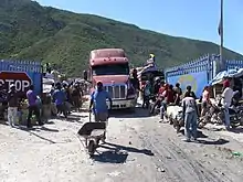
There are four official crossings points and many more unofficial ones.[21] The four official crossing points are: Malpasse-Jimaní, Ouanaminthe-Dajabón, Anse-à-Pitres-Pedernales and Belladère-Comendador.[22][6]
Gallery
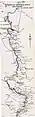 Map of the border - north
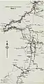 Map of the border - north central
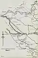 Map of the border - south central
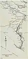 Map of the border - south
See also
References
- "Haiti". CIA World Factbook. Retrieved 2 October 2020.
- Clammer, Paul, (2016) Bradt Travel Guide – Haiti, p.11
- "Dominican Republic – The first colony". Country Studies. Library of Congress; Federal Research Division. Retrieved 19 June 2006.
- "International Boundary Study No. 5 - Dominican Republic – Haiti Boundary" (PDF). US Department of State. 23 May 1961. Retrieved 2 October 2020.
- Wucker, Michele (1999). "Roosters". Why the Cocks Fight: Dominicans, Haitians, and the Struggle for Hispaniola (1st ed.). New York: Hill and Wang. p. 13. ISBN 978-0-8090-9713-5. LCCN 98-25785. OCLC 40200381. OL 365453M.
- "The Haitian-Dominican Borderlands" (PDF). Our Border. Retrieved 2 October 2020.
- dead link] Archived October 20, 2009, at the Wayback Machine
- ""A Brief History of Dessalines", 1825 Missionary Journal". Webster University. Archived from the original on 28 December 2005. Retrieved 24 July 2013.
- Clammer, Paul, (2016) Bradt Travel Guide – Haiti, p. 209
- Gates, Henry Louis; Appiah, Anthony (1999). "Dominican-Haitian Relations". Africana: The Encyclopedia of the African and African American Experience. ISBN 9780465000715. Retrieved 2007-12-24.
- United States Geographic Board, ed. (1890–1891). First Report of the United States - Board of Geographic Names 1890-1891. Washington Government Printing Office. p. 45. Retrieved 13 September 2015.
haiti; island.
- "World Leaders Index: Dominican Republic". Archived from the original on 2015-06-20. Retrieved 2015-04-26.
- Turtis, Richard Lee (August 2002). "A World Destroyed, A Nation Imposed: The 1937 Haitian Massacre in the Dominican Republic". Hispanic American Historical Review. 82 (3): 589–635. doi:10.1215/00182168-82-3-589. S2CID 143872486. Retrieved 26 June 2020.
- Paulino, Edward (Fall 2013). "Bearing Witness to Genocide: The 1937 Haitian Massacre and Border of Lights". Afro-Hispanic Review. 32 (2): 111–118. JSTOR 24585148.
- Silver, Alexandra (2010-01-19). "Why Haiti and the Dominican Republic Are So Different". Time. Archived from the original on 2015-06-12.
- Lancer, Jalisco. "The Conflict Between Haiti and the Dominican Republic". AllEmpires. Archived from the original on 2015-12-11. Retrieved 2015-12-12.
- Schaaf, Bryan (2009-05-21). "Haiti and the Dominican Republic: Same Island, Different Worlds". Haiti Innovation. Washington, DC. Archived from the original on 2015-01-04.
- "The Dominican Republic and Haiti: one island, two nations, lots of trouble".
- "Haiti - Social : 17,271 border crossings between Haiti and the DR recorded in 8 days". Haiti Libre. Retrieved 2 October 2020.
- Clammer, Paul, (2016) Bradt Travel Guide – Haiti, p.51-2