Dry Falls (North Carolina)
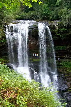
Dry Falls, also known as Upper Cullasaja Falls, is a 65-foot (20.1 m) waterfall located in the Nantahala National Forest, northwest of Highlands, North Carolina.
| Dry Falls | |
|---|---|
 Dry Falls, Aug 2009 | |
| Location | Nantahala National Forest, Macon County, in the Blue Ridge Mountains of North Carolina |
| Coordinates | 35.068091°N 83.239067°W |
| Type | Plunge |
| Total height | 65 feet (19.8 m) (Adams Book),[1] 80 ft (24.4 m) (NCWaterfalls)[2] |
| Number of drops | 1 |
Geology
Dry Falls flows on the Cullasaja River through the Nantahala National Forest. It is part of a series of waterfalls on an 8.7-mile (14 km) stretch of the river that eventually ends with Cullasaja Falls. Dry Falls flows over an overhanging bluff that allows visitors to walk up under the falls and remain relatively dry when the waterflow is low, hence its name. Visitors will get wet if the waterflow is high.
History
The falls has been called Dry Falls for a long time, but has also gone by a few other names, including High Falls, Pitcher Falls, and Cullasaja Falls.[3]
Visiting The Falls
Dry Falls is located on the side of U.S. Highway 64 3.1 miles (5.0 km) north of Highlands, North Carolina. There is a parking area on the side of the road, where visitors can park before walking the short path with stairs to the falls.
During 2008-2009 the Forest Service made improvements to the parking area, which included renovation and expansion and the addition of bathroom facilities. A new walkway and overlook were also constructed adjacent to the parking area.[4]
See also
References
- Kevin Adams, North Carolina Waterfalls, p. 466
- NCWaterfalls.com Bridal Veil and Dry Falls
- Kevin Adams, North Carolina Waterfalls, p. 467
- Nantahala National Forest Extends Contract for Dry Falls Renovations