Duffins Creek
Duffins Creek is a waterway that runs within York Region and Durham Region in the eastern end of the Greater Toronto Area.
| Duffins Creek | |
|---|---|
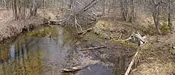 Headwaters of the West Duffins Creek, Rouge National Urban Park | |
| Location | |
| Country | Canada |
| Province | Ontario |
| Region | Greater Toronto Area |
| Municipalities | |
| Physical characteristics | |
| Source | Confluence of several branches of Duffins Creek and tributaries |
| • location | Uxbridge (Goodwood and Glen Major) Stouffville (Bloomington and Lincolnville) |
| Mouth | Duffins Marsh at Lake Ontario |
• location | Ajax |
• coordinates | 43°49′00″N 79°02′05″W |
| Basin size | 287 km2 (111 sq mi)[1] |
| Discharge | |
| • average | 1.38 m3/s (49 cu ft/s)[2] |
| • minimum | 0.51 m3/s (18 cu ft/s) |
| • maximum | 3.67 m3/s (130 cu ft/s) |
| Basin features | |
| River system | Great Lakes Basin |
History
The creek has had two other names, namely Sin-qua-trik-de-que-onk (English: pine wood on side) from the Wyandot via Augustus Jones and from the French Riviere au Saumon in reference to Atlantic Salmon that spawn in the creek,[3] the current name appears to have been for a trader known only as Duffin around 1788.[4]
List of tributaries of the Duffins Creek
Although Duffins Creek is a single waterway entering Lake Ontario at Duffins Marsh in Ajax, there are 12 other waterways that branches off Duffins towards the Oak Ridges Moraine.[5]
A list of tributaries of the main Duffins Creek:
- Stouffville Creek - name for the town for which the creek runs course off Duffins
- Reesor Creek - named for Reesor family that resides in the area in north Pickering and Markham
- West Duffins Creek - branch of main creek near Pickering Village and runs northwest towards Stouffville
- Wixon Creek
- Mitchell Creek
- East Duffins Creek
- Major Creek
- Whitevale Creek
- Urfé Creek
- Brougham Creek
- Ganatsekagon Creek
- Millers Creek
See also
- Pickering Village, Ontario - a neighbourhood in Ajax, Ontario which at one point called Duffins Creek
- Seaton, Ontario - a planned community in Pickering, Ontario
References
- https://reportcard.trca.ca/wp-content/uploads/2018/03/Duffins_Creek_Watershed_Report_Card_2013.pdf
- https://trca.ca/app/uploads/2018/02/Technical-Reports-for-2003-Watershed-Plan.compressed.pdf
- http://www.trca.on.ca/dotAsset/25929.pdf
- https://hikingthegta.com/2018/01/27/duffins-creek/
- http://trca.on.ca/dotAsset/37427.pdf
This article is issued from Wikipedia. The text is licensed under Creative Commons - Attribution - Sharealike. Additional terms may apply for the media files.