Earth
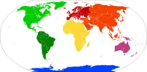
Earth is the third planet from the Sun and the only astronomical object known to harbor life. About 29% of Earth's surface is land consisting of continents and islands. The remaining 71% is covered with water, mostly by oceans but also by lakes, rivers and other fresh water, which together constitute the hydrosphere. Much of Earth's polar regions are covered in ice. Earth's outer layer is divided into several rigid tectonic plates that migrate across the surface over many millions of years. Earth's interior remains active with a solid iron inner core, a liquid outer core that generates Earth's magnetic field, and a convecting mantle that drives plate tectonics.
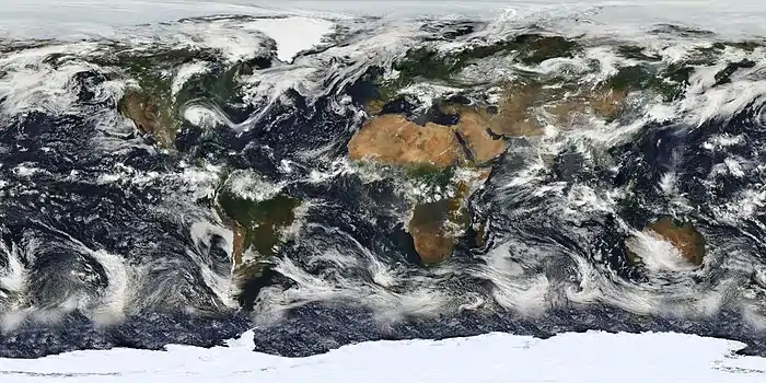
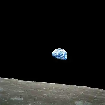
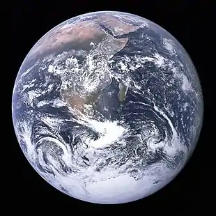 The Blue Marble, the most widely used photograph of Earth,[1][2] taken by the Apollo 17 mission in 1972. | |||||||||||||||||
| Designations | |||||||||||||||||
|---|---|---|---|---|---|---|---|---|---|---|---|---|---|---|---|---|---|
| Gaia, Gaea, Terra, Tellus, the world, the globe | |||||||||||||||||
| Adjectives | Earthly, terrestrial, terran, tellurian | ||||||||||||||||
| Orbital characteristics | |||||||||||||||||
| Epoch J2000[n 1] | |||||||||||||||||
| Aphelion | 152100000 km (94500000 mi)[n 2] | ||||||||||||||||
| Perihelion | 147095000 km (91401000 mi)[n 2] | ||||||||||||||||
| 149598023 km (92955902 mi)[3] | |||||||||||||||||
| Eccentricity | 0.0167086[3] | ||||||||||||||||
| 365.256363004 d[4] (31558.1497635 ks) | |||||||||||||||||
Average orbital speed | 29.78 km/s[5] (107200 km/h; 66600 mph) | ||||||||||||||||
| 358.617° | |||||||||||||||||
| Inclination |
| ||||||||||||||||
| −11.26064°[5] to J2000 ecliptic | |||||||||||||||||
| 2021-Jan-02 13:59[7] | |||||||||||||||||
| 114.20783°[5] | |||||||||||||||||
| Satellites |
| ||||||||||||||||
| Physical characteristics | |||||||||||||||||
Mean radius | 6371.0 km (3958.8 mi)[9] | ||||||||||||||||
Equatorial radius | 6378.1 km (3963.2 mi)[10][11] | ||||||||||||||||
Polar radius | 6356.8 km (3949.9 mi) | ||||||||||||||||
| Flattening | 0.0033528[13] 1/298.257222101 (ETRS89) | ||||||||||||||||
| Circumference |
| ||||||||||||||||
| Volume | 1.08321×10¹² km3 (2.59876×10¹¹ cu mi)[5] | ||||||||||||||||
| Mass | 5.97237×1024 kg (1.31668×1025 lb)[16] (3.0×10⁻⁶ M☉) | ||||||||||||||||
Mean density | 5.514 g/cm3 (0.1992 lb/cu in)[5] | ||||||||||||||||
| 9.80665 m/s2 (1 g; 32.1740 ft/s2)[17] | |||||||||||||||||
| 0.3307[18] | |||||||||||||||||
| 11.186 km/s[5] (40270 km/h; 25020 mph) | |||||||||||||||||
Sidereal rotation period | |||||||||||||||||
Equatorial rotation velocity | 0.4651 km/s[20] (1674.4 km/h; 1040.4 mph) | ||||||||||||||||
| 23.4392811°[4] | |||||||||||||||||
| Albedo | |||||||||||||||||
| |||||||||||||||||
| Atmosphere | |||||||||||||||||
Surface pressure | 101.325 kPa (at MSL) | ||||||||||||||||
| Composition by volume | |||||||||||||||||
According to radiometric dating estimation and other evidence, Earth formed over 4.5 billion years ago. Within the first billion years of Earth's history, life appeared in the oceans and began to affect Earth's atmosphere and surface, leading to the proliferation of anaerobic and, later, aerobic organisms. Some geological evidence indicates that life may have arisen as early as 4.1 billion years ago. Since then, the combination of Earth's distance from the Sun, physical properties and geological history have allowed life to evolve and thrive. In the history of life on Earth, biodiversity has gone through long periods of expansion, occasionally punctuated by mass extinctions. Over 99% of all species that ever lived on Earth are extinct. Almost 8 billion humans live on Earth and depend on its biosphere and natural resources for their survival. Humans increasingly impact Earth's hydrology, atmospheric processes and other life.
Earth's atmosphere consists mostly of nitrogen and oxygen. Tropical regions receive more energy from the Sun than polar regions, which is redistributed by atmospheric and ocean circulation. Greenhouse gases also play an important role in regulating the surface temperature. A region's climate is not only determined by latitude, but also by its proximity to moderating oceans and height, among other factors. Extreme weather, such as tropical cyclones and heat waves, occurs in most areas and has a large impact on life.
Earth's gravity interacts with other objects in space, especially the Sun and the Moon, which is Earth's only natural satellite. Earth orbits around the Sun in about 365.25 days. Earth's axis of rotation is tilted with respect to its orbital plane, producing seasons on Earth. The gravitational interaction between Earth and the Moon causes tides, stabilizes Earth's orientation on its axis, and gradually slows its rotation. Earth is the densest planet in the Solar System and the largest and most massive of the four rocky planets.
Etymology
The modern English word Earth developed, via Middle English, from an Old English noun most often spelled eorðe.[25] It has cognates in every Germanic language, and their ancestral root has been reconstructed as *erþō. In its earliest attestation, the word eorðe was already being used to translate the many senses of Latin terra and Greek γῆ gē: the ground, its soil, dry land, the human world, the surface of the world (including the sea), and the globe itself. As with Roman Terra/Tellūs and Greek Gaia, Earth may have been a personified goddess in Germanic paganism: late Norse mythology included Jörð ('Earth'), a giantess often given as the mother of Thor.[26]
Historically, earth has been written in lowercase. From early Middle English, its definite sense as "the globe" was expressed as the earth. By Early Modern English, many nouns were capitalized, and the earth was also written the Earth, particularly when referenced along with other heavenly bodies. More recently, the name is sometimes simply given as Earth, by analogy with the names of the other planets, though earth and forms with the remain common.[25] House styles now vary: Oxford spelling recognizes the lowercase form as the most common, with the capitalized form an acceptable variant. Another convention capitalizes "Earth" when appearing as a name (for example, "Earth's atmosphere") but writes it in lowercase when preceded by the (for example, "the atmosphere of the earth"). It almost always appears in lowercase in colloquial expressions such as "what on earth are you doing?"[27]
Occasionally, the name Terra /ˈtɛrə/ is used in scientific writing and especially in science fiction to distinguish humanity's inhabited planet from others,[28] while in poetry Tellus /ˈtɛləs/ has been used to denote personification of the Earth.[29] The Greek poetic name Gaea (Gæa) /ˈdʒiːə/ is rare, though the alternative spelling Gaia has become common due to the Gaia hypothesis, in which case its pronunciation is /ˈɡaɪə/ rather than the more Classical /ˈɡeɪə/.[30]
There are a number of adjectives for the planet Earth. From Earth itself comes earthly. From the Latin Terra comes terran /ˈtɛrən/,[31] terrestrial /təˈrɛstriəl/,[32] and (via French) terrene /təˈriːn/,[33] and from the Latin Tellus comes tellurian /tɛˈlʊəriən/[34] and telluric.[35]
Chronology
Formation
The oldest material found in the Solar System is dated to 4.5682+0.0002
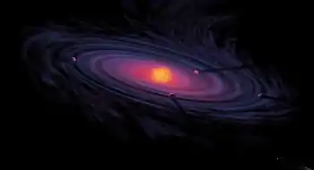
−0.0004 Ga (billion years) ago.[36] By 4.54±0.04 Ga the primordial Earth had formed.[37] The bodies in the Solar System formed and evolved with the Sun. In theory, a solar nebula partitions a volume out of a molecular cloud by gravitational collapse, which begins to spin and flatten into a circumstellar disk, and then the planets grow out of that disk with the Sun. A nebula contains gas, ice grains, and dust (including primordial nuclides). According to nebular theory, planetesimals formed by accretion, with the primordial Earth being estimated as likely taking anywhere from 70–100 million years to form.[38]
Estimates of the age of the Moon range from 4.5 Ga to significantly younger.[39] A leading hypothesis is that it was formed by accretion from material loosed from Earth after a Mars-sized object with about 10% of Earth's mass, named Theia, collided with Earth.[40] It hit Earth with a glancing blow and some of its mass merged with Earth.[41][42] Between approximately 4.1 and 3.8 Ga, numerous asteroid impacts during the Late Heavy Bombardment caused significant changes to the greater surface environment of the Moon and, by inference, to that of Earth.[43]
Geological history
Earth's atmosphere and oceans were formed by volcanic activity and outgassing.[44] Water vapor from these sources condensed into the oceans, augmented by water and ice from asteroids, protoplanets, and comets.[45] Sufficient water to fill the oceans may have always been on Earth since the beginning of the planet's formation.[46] In this model, atmospheric greenhouse gases kept the oceans from freezing when the newly forming Sun had only 70% of its current luminosity.[47] By 3.5 Ga, Earth's magnetic field was established, which helped prevent the atmosphere from being stripped away by the solar wind.[48]
As the molten outer layer of Earth cooled it formed the first solid crust, which is thought to have been mafic in composition. The first continental crust, which was more felsic in composition, formed by the partial melting of this mafic crust. The presence of grains of the mineral zircon of Hadean age in Eoarchean sedimentary rocks suggests that at least some felsic crust existed as early as 4.4 Ga, only 140 Ma after Earth's formation.[49] There are two main models of how this initial small volume of continental crust evolved to reach its current abundance:[50] (1) a relatively steady growth up to the present day,[51] which is supported by the radiometric dating of continental crust globally and (2) an initial rapid growth in the volume of continental crust during the Archean, forming the bulk of the continental crust that now exists,[52][53] which is supported by isotopic evidence from hafnium in zircons and neodymium in sedimentary rocks. The two models and the data that support them can be reconciled by large-scale recycling of the continental crust, particularly during the early stages of Earth's history.[54]
New continental crust forms as a result of plate tectonics, a process ultimately driven by the continuous loss of heat from Earth's interior. Over the period of hundreds of millions of years, tectonic forces have caused areas of continental crust to group together to form supercontinents that have subsequently broken apart. At approximately 750 Ma, one of the earliest known supercontinents, Rodinia, began to break apart. The continents later recombined to form Pannotia at 600–540 Ma, then finally Pangaea, which also began to break apart at 180 Ma.[55]
The most recent pattern of ice ages began about 40 Ma,[56] and then intensified during the Pleistocene about 3 Ma.[57] High- and middle-latitude regions have since undergone repeated cycles of glaciation and thaw, repeating about every 21,000, 41,000 and 100,000 years.[58] The Last Glacial Period, colloquially called the "last ice age", covered large parts of the continents, up to the middle latitudes, in ice and ended about 11,700 years ago.[59]
Origin of life and evolution
Chemical reactions led to the first self-replicating molecules about four billion years ago. A half billion years later, the last common ancestor of all current life arose.[60] The evolution of photosynthesis allowed the Sun's energy to be harvested directly by life forms. The resultant molecular oxygen (O
2) accumulated in the atmosphere and due to interaction with ultraviolet solar radiation, formed a protective ozone layer (O
3) in the upper atmosphere.[61] The incorporation of smaller cells within larger ones resulted in the development of complex cells called eukaryotes.[62] True multicellular organisms formed as cells within colonies became increasingly specialized. Aided by the absorption of harmful ultraviolet radiation by the ozone layer, life colonized Earth's surface.[63] Among the earliest fossil evidence for life is microbial mat fossils found in 3.48 billion-year-old sandstone in Western Australia,[64] biogenic graphite found in 3.7 billion-year-old metasedimentary rocks in Western Greenland,[65] and remains of biotic material found in 4.1 billion-year-old rocks in Western Australia.[66][67] The earliest direct evidence of life on Earth is contained in 3.45 billion-year-old Australian rocks showing fossils of microorganisms.[68][69]
During the Neoproterozoic, 1000 to 541 Ma, much of Earth might have been covered in ice. This hypothesis has been termed "Snowball Earth", and it is of particular interest because it preceded the Cambrian explosion, when multicellular life forms significantly increased in complexity.[70][71] Following the Cambrian explosion, 535 Ma, there have been at least five major mass extinctions and many minor ones.[72][73] Apart from the proposed current Holocene extinction event, the most recent was 66 Ma, when an asteroid impact triggered the extinction of the non-avian dinosaurs and other large reptiles, but largely spared small animals such as insects, mammals, lizards and birds. Mammalian life has diversified over the past 66 Mys, and several million years ago an African ape gained the ability to stand upright.[74] This facilitated tool use and encouraged communication that provided the nutrition and stimulation needed for a larger brain, which led to the evolution of humans. The development of agriculture, and then civilization, led to humans having an influence on Earth and the nature and quantity of other life forms that continues to this day.[75] Over 99% of all species that ever lived on Earth are extinct.[76][77]
Future
Because carbon dioxide (CO
2) has a long life time in the atmosphere, moderate human CO
2 emissions may postpone the next glacial inception by 100,000 years.[78] Earth's expected long-term future is tied to that of the Sun. Over the next 1.1 billion years, solar luminosity will increase by 10%, and over the next 3.5 billion years by 40%.[79] Earth's increasing surface temperature will accelerate the inorganic carbon cycle, reducing CO
2 concentration to levels lethally low for plants (10 ppm for C4 photosynthesis) in approximately 100–900 million years.[80][81] The lack of vegetation will result in the loss of oxygen in the atmosphere, making animal life impossible.[82] Due to the increased luminosity, Earth's mean tempearture may reach 100 °C (212 °F) in 1.5 billion years, and all ocean water will evaporate and be lost to space within an estimated 1.6 to 3 billion years.[83] Even if the Sun were stable, a fraction of the water in the modern oceans will descend to the mantle, due to reduced steam venting from mid-ocean ridges.[83][84]
The Sun will evolve to become a red giant in about 5 billion years. Models predict that the Sun will expand to roughly 1 AU (150 million km; 93 million mi), about 250 times its present radius.[79][85] Earth's fate is less clear. As a red giant, the Sun will lose roughly 30% of its mass, so, without tidal effects, Earth will move to an orbit 1.7 AU (250 million km; 160 million mi) from the Sun when the star reaches its maximum radius.[79]
Physical characteristics
Shape
The shape of Earth is nearly spherical. There is a small flattening at the poles and bulging around the equator due to Earth's rotation.[87] so that a better approximation of Earth's shape is an oblate spheroid, whose equatorial diameter is 43 kilometres (27 mi) larger than the pole-to-pole diameter.[88]
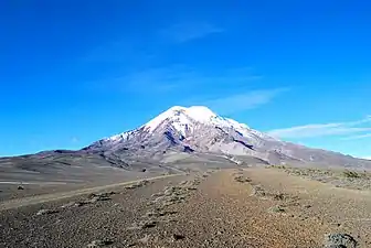
The point on the surface farthest from Earth's center of mass is the summit of the equatorial Chimborazo volcano in Ecuador (6,384.4 km or 3,967.1 mi).[89][90][91] The average diameter of the reference spheroid is 12,742 kilometres (7,918 mi). Local topography deviates from this idealized spheroid, although on a global scale these deviations are small compared to Earth's radius: the maximum deviation of only 0.17% is at the Mariana Trench (10,925 metres or 35,843 feet below local sea level),[92] whereas Mount Everest (8,848 metres or 29,029 feet above local sea level) represents a deviation of 0.14%.[n 6][94] In geodesy, the exact shape that Earth's oceans would adopt in the absence of land and perturbations such as tides and winds is called the geoid. More precisely, the geoid is the surface of gravitational equipotential at mean sea level.[95]
Chemical composition
| Compound | Formula | Composition | |
|---|---|---|---|
| Continental | Oceanic | ||
| silica | SiO 2 |
60.6% | 48.6% |
| alumina | Al 2O 3 |
15.9% | 16.5% |
| lime | CaO | 6.41% | 12.3% |
| magnesia | MgO | 4.66% | 6.8% |
| iron oxide | FeOT | 6.71% | 6.2% |
| sodium oxide | Na 2O |
3.07% | 2.6% |
| potassium oxide | K 2O |
1.81% | 0.4% |
| titanium dioxide | TiO 2 |
0.72% | 1.4% |
| phosphorus pentoxide | P 2O 5 |
0.13% | 0.3% |
| manganese oxide | MnO | 0.10% | 1.4% |
| Total | 100.1% | 99.9% | |
Earth's mass is approximately 5.97×1024 kg (5,970 Yg). It is composed mostly of iron (32.1%), oxygen (30.1%), silicon (15.1%), magnesium (13.9%), sulfur (2.9%), nickel (1.8%), calcium (1.5%), and aluminum (1.4%), with the remaining 1.2% consisting of trace amounts of other elements. Due to mass segregation, the core region is estimated to be primarily composed of iron (88.8%), with smaller amounts of nickel (5.8%), sulfur (4.5%), and less than 1% trace elements.[98]
The most common rock constituents of the crust are nearly all oxides: chlorine, sulfur, and fluorine are the important exceptions to this and their total amount in any rock is usually much less than 1%. Over 99% of the crust is composed of 11 oxides, principally silica, alumina, iron oxides, lime, magnesia, potash and soda.[99][98]
Internal structure
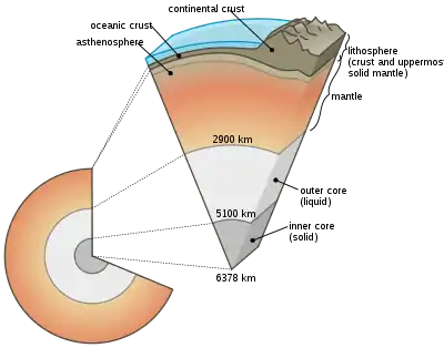 Earth cutaway from core to exosphere. Not to scale. | ||
|---|---|---|
| Depth[101] km |
Component layer | Density g/cm3 |
| 0–60 | Lithosphere[n 7] | — |
| 0–35 | Crust[n 8] | 2.2–2.9 |
| 35–660 | Upper mantle | 3.4–4.4 |
| 660–2890 | Lower mantle | 3.4–5.6 |
| 100–700 | Asthenosphere | — |
| 2890–5100 | Outer core | 9.9–12.2 |
| 5100–6378 | Inner core | 12.8–13.1 |
Earth's interior, like that of the other terrestrial planets, is divided into layers by their chemical or physical (rheological) properties. The outer layer is a chemically distinct silicate solid crust, which is underlain by a highly viscous solid mantle. The crust is separated from the mantle by the Mohorovičić discontinuity.[102] The thickness of the crust varies from about 6 kilometres (3.7 mi) under the oceans to 30–50 km (19–31 mi) for the continents. The crust and the cold, rigid, top of the upper mantle are collectively known as the lithosphere, which is divided into independently moving tectonic plates.[103]
Beneath the lithosphere is the asthenosphere, a relatively low-viscosity layer on which the lithosphere rides. Important changes in crystal structure within the mantle occur at 410 and 660 km (250 and 410 mi) below the surface, spanning a transition zone that separates the upper and lower mantle. Beneath the mantle, an extremely low viscosity liquid outer core lies above a solid inner core.[104] Earth's inner core may be rotating at a slightly higher angular velocity than the remainder of the planet, advancing by 0.1–0.5° per year, although both somewhat higher and much lower rates have also been proposed.[105] The radius of the inner core is about one fifth of that of Earth. Density increases with depth, as described in the table on the right.
Heat
The major heat-producing isotopes within Earth are potassium-40, uranium-238, and thorium-232.[106] At the center, the temperature may be up to 6,000 °C (10,830 °F),[107] and the pressure could reach 360 GPa (52 million psi).[108] Because much of the heat is provided by radioactive decay, scientists postulate that early in Earth's history, before isotopes with short half-lives were depleted, Earth's heat production was much higher. At approximately 3 Gyr, twice the present-day heat would have been produced, increasing the rates of mantle convection and plate tectonics, and allowing the production of uncommon igneous rocks such as komatiites that are rarely formed today.[109][110]
| Isotope | Heat release W/kg isotope |
Half-life years |
Mean mantle concentration kg isotope/kg mantle |
Heat release W/kg mantle |
|---|---|---|---|---|
| 238U | 94.6×10⁻⁶ | 4.47×10⁹ | 30.8×10⁻⁹ | 2.91×10⁻¹² |
| 235U | 569×10−6 | 0.704×10⁹ | 0.22×10⁻⁹ | 0.125×10⁻¹² |
| 232Th | 26.4×10⁻⁶ | 14.0×10⁹ | 124×10−9 | 3.27×10⁻¹² |
| 40K | 29.2×10⁻⁶ | 1.25×10⁹ | 36.9×10⁻⁹ | 1.08×10⁻¹² |
The mean heat loss from Earth is 87 mW m−2, for a global heat loss of 4.42×10¹³ W.[111] A portion of the core's thermal energy is transported toward the crust by mantle plumes, a form of convection consisting of upwellings of higher-temperature rock. These plumes can produce hotspots and flood basalts.[112] More of the heat in Earth is lost through plate tectonics, by mantle upwelling associated with mid-ocean ridges. The final major mode of heat loss is through conduction through the lithosphere, the majority of which occurs under the oceans because the crust there is much thinner than that of the continents.[113]
Tectonic plates
| Plate name | Area 106 km2 |
|---|---|
| 103.3 | |
| 78.0 | |
| 75.9 | |
| 67.8 | |
| 60.9 | |
| 47.2 | |
| 43.6 | |
Earth's mechanically rigid outer layer, the lithosphere, is divided into tectonic plates. These plates are rigid segments that move relative to each other at one of three boundaries types: at convergent boundaries, two plates come together; at divergent boundaries, two plates are pulled apart; and at transform boundaries, two plates slide past one another laterally. Along these plate boundaries, earthquakes, volcanic activity, mountain-building, and oceanic trench formation can occur.[115] The tectonic plates ride on top of the asthenosphere, the solid but less-viscous part of the upper mantle that can flow and move along with the plates.[116]
As the tectonic plates migrate, oceanic crust is subducted under the leading edges of the plates at convergent boundaries. At the same time, the upwelling of mantle material at divergent boundaries creates mid-ocean ridges. The combination of these processes recycles the oceanic crust back into the mantle. Due to this recycling, most of the ocean floor is less than 100 Ma old. The oldest oceanic crust is located in the Western Pacific and is estimated to be 200 Ma old.[117][118] By comparison, the oldest dated continental crust is 4,030 Ma,[119] although zircons have been found preserved as clasts within Eoarchean sedimentary rocks that give ages up to 4,400 Ma, indicating that at least some continental crust existed at that time.[49]
The seven major plates are the Pacific, North American, Eurasian, African, Antarctic, Indo-Australian, and South American. Other notable plates include the Arabian Plate, the Caribbean Plate, the Nazca Plate off the west coast of South America and the Scotia Plate in the southern Atlantic Ocean. The Australian Plate fused with the Indian Plate between 50 and 55 Ma. The fastest-moving plates are the oceanic plates, with the Cocos Plate advancing at a rate of 75 mm/a (3.0 in/year)[120] and the Pacific Plate moving 52–69 mm/a (2.0–2.7 in/year). At the other extreme, the slowest-moving plate is the South American Plate, progressing at a typical rate of 10.6 mm/a (0.42 in/year).[121]
Surface
The total surface area of Earth is about 510 million km2 (197 million sq mi).[15] Of this, 70.8%,[15] or 361.13 million km2 (139.43 million sq mi), is below sea level and covered by ocean water.[122] Below the ocean's surface are much of the continental shelf, mountains, volcanoes,[88] oceanic trenches, submarine canyons, oceanic plateaus, abyssal plains, and a globe-spanning mid-ocean ridge system. The remaining 29.2%, or 148.94 million km2 (57.51 million sq mi), not covered by water has terrain that varies greatly from place to place and consists of mountains, deserts, plains, plateaus, and other landforms. The elevation of the land surface varies from the low point of −418 m (−1,371 ft) at the Dead Sea, to a maximum altitude of 8,848 m (29,029 ft) at the top of Mount Everest. The mean height of land above sea level is about 797 m (2,615 ft).[123]
The continental crust consists of lower density material such as the igneous rocks granite and andesite. Less common is basalt, a denser volcanic rock that is the primary constituent of the ocean floors.[124] Sedimentary rock is formed from the accumulation of sediment that becomes buried and compacted together. Nearly 75% of the continental surfaces are covered by sedimentary rocks, although they form about 5% of the crust.[125] The third form of rock material found on Earth is metamorphic rock, which is created from the transformation of pre-existing rock types through high pressures, high temperatures, or both. The most abundant silicate minerals on Earth's surface include quartz, feldspars, amphibole, mica, pyroxene and olivine.[126] Common carbonate minerals include calcite (found in limestone) and dolomite.[127]
Erosion and tectonics, volcanic eruptions, flooding, weathering, glaciation, the growth of coral reefs, and meteorite impacts are among the processes that constantly reshape Earth's surface over geological time.[128][129]
The pedosphere is the outermost layer of Earth's continental surface and is composed of soil and subject to soil formation processes. The total arable land is 10.9% of the land surface, with 1.3% being permanent cropland.[130][131] Close to 40% of Earth's land surface is used for agriculture, or an estimated 16.7 million km2 (6.4 million sq mi) of cropland and 33.5 million km2 (12.9 million sq mi) of pastureland.[132]
Gravitational field
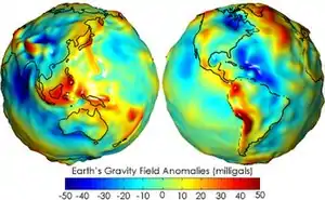
The gravity of Earth is the acceleration that is imparted to objects due to the distribution of mass within Earth. Near Earth's surface, gravitational acceleration is approximately 9.8 m/s2 (32 ft/s2). Local differences in topography, geology, and deeper tectonic structure cause local and broad, regional differences in Earth's gravitational field, known as gravity anomalies.[133]
Magnetic field
The main part of Earth's magnetic field is generated in the core, the site of a dynamo process that converts the kinetic energy of thermally and compositionally driven convection into electrical and magnetic field energy. The field extends outwards from the core, through the mantle, and up to Earth's surface, where it is, approximately, a dipole. The poles of the dipole are located close to Earth's geographic poles. At the equator of the magnetic field, the magnetic-field strength at the surface is 3.05×10⁻⁵ T, with a magnetic dipole moment of 7.79×10²² Am2 at epoch 2000, decreasing nearly 6% per century.[134] The convection movements in the core are chaotic; the magnetic poles drift and periodically change alignment. This causes secular variation of the main field and field reversals at irregular intervals averaging a few times every million years. The most recent reversal occurred approximately 700,000 years ago.[135][136]
Magnetosphere
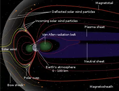
The extent of Earth's magnetic field in space defines the magnetosphere. Ions and electrons of the solar wind are deflected by the magnetosphere; solar wind pressure compresses the dayside of the magnetosphere, to about 10 Earth radii, and extends the nightside magnetosphere into a long tail.[137] Because the velocity of the solar wind is greater than the speed at which waves propagate through the solar wind, a supersonic bow shock precedes the dayside magnetosphere within the solar wind.[138] Charged particles are contained within the magnetosphere; the plasmasphere is defined by low-energy particles that essentially follow magnetic field lines as Earth rotates.[139][140] The ring current is defined by medium-energy particles that drift relative to the geomagnetic field, but with paths that are still dominated by the magnetic field,[141] and the Van Allen radiation belts are formed by high-energy particles whose motion is essentially random, but contained in the magnetosphere.[142][143]
During magnetic storms and substorms, charged particles can be deflected from the outer magnetosphere and especially the magnetotail, directed along field lines into Earth's ionosphere, where atmospheric atoms can be excited and ionized, causing the aurora.[144]
Orbit and rotation
Rotation
.gif)
Earth's rotation period relative to the Sun—its mean solar day—is 86,400 seconds of mean solar time (86,400.0025 SI seconds).[145] Because Earth's solar day is now slightly longer than it was during the 19th century due to tidal deceleration, each day varies between 0 and 2 ms longer than the mean solar day.[146][147]
Earth's rotation period relative to the fixed stars, called its stellar day by the International Earth Rotation and Reference Systems Service (IERS), is 86,164.0989 seconds of mean solar time (UT1), or 23h 56m 4.0989s.[4][n 10] Earth's rotation period relative to the precessing or moving mean March equinox (when the Sun is at 90° on the equator), is 86,164.0905 seconds of mean solar time (UT1) (23h 56m 4.0905s).[4] Thus the sidereal day is shorter than the stellar day by about 8.4 ms.[148]
Apart from meteors within the atmosphere and low-orbiting satellites, the main apparent motion of celestial bodies in Earth's sky is to the west at a rate of 15°/h = 15'/min. For bodies near the celestial equator, this is equivalent to an apparent diameter of the Sun or the Moon every two minutes; from Earth's surface, the apparent sizes of the Sun and the Moon are approximately the same.[149][150]
Orbit
Earth orbits the Sun at an average distance of about 150 million km (93 million mi) every 365.2564 mean solar days, or one sidereal year. This gives an apparent movement of the Sun eastward with respect to the stars at a rate of about 1°/day, which is one apparent Sun or Moon diameter every 12 hours. Due to this motion, on average it takes 24 hours—a solar day—for Earth to complete a full rotation about its axis so that the Sun returns to the meridian. The orbital speed of Earth averages about 29.78 km/s (107,200 km/h; 66,600 mph), which is fast enough to travel a distance equal to Earth's diameter, about 12,742 km (7,918 mi), in seven minutes, and the distance to the Moon, 384,000 km (239,000 mi), in about 3.5 hours.[5]
The Moon and Earth orbit a common barycenter every 27.32 days relative to the background stars. When combined with the Earth–Moon system's common orbit around the Sun, the period of the synodic month, from new moon to new moon, is 29.53 days. Viewed from the celestial north pole, the motion of Earth, the Moon, and their axial rotations are all counterclockwise. Viewed from a vantage point above the north poles of both the Sun and Earth, Earth orbits in a counterclockwise direction about the Sun. The orbital and axial planes are not precisely aligned: Earth's axis is tilted some 23.44 degrees from the perpendicular to the Earth–Sun plane (the ecliptic), and the Earth–Moon plane is tilted up to ±5.1 degrees against the Earth–Sun plane. Without this tilt, there would be an eclipse every two weeks, alternating between lunar eclipses and solar eclipses.[5][152]
The Hill sphere, or the sphere of gravitational influence, of Earth is about 1.5 million km (930,000 mi) in radius.[153][n 11] This is the maximum distance at which Earth's gravitational influence is stronger than the more distant Sun and planets. Objects must orbit Earth within this radius, or they can become unbound by the gravitational perturbation of the Sun.[153]
Earth, along with the Solar System, is situated in the Milky Way and orbits about 28,000 light-years from its center. It is about 20 light-years above the galactic plane in the Orion Arm.[154]
Axial tilt and seasons
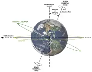
The axial tilt of Earth is approximately 23.439281°[4] with the axis of its orbit plane, always pointing towards the Celestial Poles. Due to Earth's axial tilt, the amount of sunlight reaching any given point on the surface varies over the course of the year. This causes the seasonal change in climate, with summer in the Northern Hemisphere occurring when the Tropic of Cancer is facing the Sun, and winter taking place when the Tropic of Capricorn in the Southern Hemisphere faces the Sun. During the summer, the day lasts longer, and the Sun climbs higher in the sky. In winter, the climate becomes cooler and the days shorter.[155] Above the Arctic Circle and below the Antarctic Circle there is no daylight at all for part of the year, causing a polar night, and this night extends for several months at the poles themselves. These same latitudes also experience a midnight sun, where the sun remains visible all day.[156][157]
By astronomical convention, the four seasons can be determined by the solstices—the points in the orbit of maximum axial tilt toward or away from the Sun—and the equinoxes, when Earth's rotational axis is aligned with its orbital axis. In the Northern Hemisphere, winter solstice currently occurs around 21 December; summer solstice is near 21 June, spring equinox is around 20 March and autumnal equinox is about 22 or 23 September. In the Southern Hemisphere, the situation is reversed, with the summer and winter solstices exchanged and the spring and autumnal equinox dates swapped.[158]
The angle of Earth's axial tilt is relatively stable over long periods of time. Its axial tilt does undergo nutation; a slight, irregular motion with a main period of 18.6 years.[159] The orientation (rather than the angle) of Earth's axis also changes over time, precessing around in a complete circle over each 25,800 year cycle; this precession is the reason for the difference between a sidereal year and a tropical year. Both of these motions are caused by the varying attraction of the Sun and the Moon on Earth's equatorial bulge. The poles also migrate a few meters across Earth's surface. This polar motion has multiple, cyclical components, which collectively are termed quasiperiodic motion. In addition to an annual component to this motion, there is a 14-month cycle called the Chandler wobble. Earth's rotational velocity also varies in a phenomenon known as length-of-day variation.[160]
In modern times, Earth's perihelion occurs around 3 January, and its aphelion around 4 July. These dates change over time due to precession and other orbital factors, which follow cyclical patterns known as Milankovitch cycles. The changing Earth–Sun distance causes an increase of about 6.8% in solar energy reaching Earth at perihelion relative to aphelion.[161][n 12] Because the Southern Hemisphere is tilted toward the Sun at about the same time that Earth reaches the closest approach to the Sun, the Southern Hemisphere receives slightly more energy from the Sun than does the northern over the course of a year. This effect is much less significant than the total energy change due to the axial tilt, and most of the excess energy is absorbed by the higher proportion of water in the Southern Hemisphere.[162]
Earth-Moon system
Moon
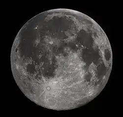 Full moon as seen from Earth's Northern Hemisphere | |
| Diameter | 3,474.8 km |
| Mass | 7.349×10²² kg |
| Semi-major axis | 384,400 km |
| Orbital period | 27d 7h 43.7m |
The Moon is a relatively large, terrestrial, planet-like natural satellite, with a diameter about one-quarter of Earth's. It is the largest moon in the Solar System relative to the size of its planet, although Charon is larger relative to the dwarf planet Pluto.[163][164] The natural satellites of other planets are also referred to as "moons", after Earth's.[165] The most widely accepted theory of the Moon's origin, the giant-impact hypothesis, states that it formed from the collision of a Mars-size protoplanet called Theia with the early Earth. This hypothesis explains (among other things) the Moon's relative lack of iron and volatile elements and the fact that its composition is nearly identical to that of Earth's crust.[41]
The gravitational attraction between Earth and the Moon causes tides on Earth.[166] The same effect on the Moon has led to its tidal locking: its rotation period is the same as the time it takes to orbit Earth. As a result, it always presents the same face to the planet.[167] As the Moon orbits Earth, different parts of its face are illuminated by the Sun, leading to the lunar phases.[168] Due to their tidal interaction, the Moon recedes from Earth at the rate of approximately 38 mm/a (1.5 in/year). Over millions of years, these tiny modifications—and the lengthening of Earth's day by about 23 µs/yr—add up to significant changes.[169] During the Ediacaran period, for example, (approximately 620 Ma) there were 400±7 days in a year, with each day lasting 21.9±0.4 hours.[170]
The Moon may have dramatically affected the development of life by moderating the planet's climate. Paleontological evidence and computer simulations show that Earth's axial tilt is stabilized by tidal interactions with the Moon.[171] Some theorists think that without this stabilization against the torques applied by the Sun and planets to Earth's equatorial bulge, the rotational axis might be chaotically unstable, exhibiting large changes over millions of years, as is the case for Mars, though this is disputed.[172][173]
Viewed from Earth, the Moon is just far enough away to have almost the same apparent-sized disk as the Sun. The angular size (or solid angle) of these two bodies match because, although the Sun's diameter is about 400 times as large as the Moon's, it is also 400 times more distant.[150] This allows total and annular solar eclipses to occur on Earth.[174]
Asteroids and artificial satellites

Earth's co-orbital asteroids population consists of quasi-satellites, objects with a horseshoe orbit and trojans. There are at least five quasi-satellites, including 469219 Kamoʻoalewa.[175][176] A trojan asteroid companion, 2010 TK7, is librating around the leading Lagrange triangular point, L4, in Earth's orbit around the Sun.[177][178] The tiny near-Earth asteroid 2006 RH120 makes close approaches to the Earth–Moon system roughly every twenty years. During these approaches, it can orbit Earth for brief periods of time.[179]
As of April 2020, there are 2,666 operational, human-made satellites orbiting Earth.[8] There are also inoperative satellites, including Vanguard 1, the oldest satellite currently in orbit, and over 16,000 pieces of tracked space debris.[n 3] Earth's largest artificial satellite is the International Space Station.[180]
Hydrosphere
The abundance of water on Earth's surface is a unique feature that distinguishes the "Blue Planet" from other planets in the Solar System. Earth's hydrosphere consists chiefly of the oceans, but technically includes all water surfaces in the world, including inland seas, lakes, rivers, and underground waters down to a depth of 2,000 m (6,600 ft). The mass of the oceans is approximately 1.35×10¹⁸ metric tons or about 1/4400 of Earth's total mass. The oceans cover an area of 361.8 million km2 (139.7 million sq mi) with a mean depth of 3,682 m (12,080 ft), resulting in an estimated volume of 1.332 billion km3 (320 million cu mi).[181] If all of Earth's crustal surface were at the same elevation as a smooth sphere, the depth of the resulting world ocean would be 2.7 to 2.8 km (1.68 to 1.74 mi).[182] About 97.5% of the water is saline; the remaining 2.5% is fresh water.[183][184] Most fresh water, about 68.7%, is present as ice in ice caps and glaciers.[185]
In Earth's coldest regions, snow survives over the summer and changes into ice. This accumulated snow and ice eventually forms into glaciers, bodies of ice that flow under the influence of their own gravity. Alpine glaciers form in mountainous areas, whereas vast ice sheets form over land in polar regions. The flow of glaciers erodes the surface changing it dramatically, with the formation of U-shaped valleys and other landforms.[186] Sea ice in the Arctic covers an area about as big as the United States, although it is quickly retreating as a consequence of climate change.[187]
The average salinity of Earth's oceans is about 35 grams of salt per kilogram of sea water (3.5% salt).[188] Most of this salt was released from volcanic activity or extracted from cool igneous rocks.[189] The oceans are also a reservoir of dissolved atmospheric gases, which are essential for the survival of many aquatic life forms.[190] Sea water has an important influence on the world's climate, with the oceans acting as a large heat reservoir.[191] Shifts in the oceanic temperature distribution can cause significant weather shifts, such as the El Niño–Southern Oscillation.[192]
Atmosphere
The atmospheric pressure at Earth's sea level averages 101.325 kPa (14.696 psi),[193] with a scale height of about 8.5 km (5.3 mi).[5] A dry atmosphere is composed of 78.084% nitrogen, 20.946% oxygen, 0.934% argon, and trace amounts of carbon dioxide and other gaseous molecules.[193] Water vapor content varies between 0.01% and 4%[193] but averages about 1%.[5] The height of the troposphere varies with latitude, ranging between 8 km (5 mi) at the poles to 17 km (11 mi) at the equator, with some variation resulting from weather and seasonal factors.[194]
Earth's biosphere has significantly altered its atmosphere. Oxygenic photosynthesis evolved 2.7 Gya, forming the primarily nitrogen–oxygen atmosphere of today.[61] This change enabled the proliferation of aerobic organisms and, indirectly, the formation of the ozone layer due to the subsequent conversion of atmospheric O
2 into O
3. The ozone layer blocks ultraviolet solar radiation, permitting life on land.[195] Other atmospheric functions important to life include transporting water vapor, providing useful gases, causing small meteors to burn up before they strike the surface, and moderating temperature.[196] This last phenomenon is known as the greenhouse effect: trace molecules within the atmosphere serve to capture thermal energy emitted from the ground, thereby raising the average temperature. Water vapor, carbon dioxide, methane, nitrous oxide, and ozone are the primary greenhouse gases in the atmosphere. Without this heat-retention effect, the average surface temperature would be −18 °C (0 °F), in contrast to the current +15 °C (59 °F),[197] and life on Earth probably would not exist in its current form.[198]
Weather and climate
Earth's atmosphere has no definite boundary, slowly becoming thinner and fading into outer space. Three-quarters of the atmosphere's mass is contained within the first 11 km (6.8 mi) of the surface. This lowest layer is called the troposphere. Energy from the Sun heats this layer, and the surface below, causing expansion of the air. This lower-density air then rises and is replaced by cooler, higher-density air. The result is atmospheric circulation that drives the weather and climate through redistribution of thermal energy.[199]
The primary atmospheric circulation bands consist of the trade winds in the equatorial region below 30° latitude and the westerlies in the mid-latitudes between 30° and 60°.[200] Ocean currents are also important factors in determining climate, particularly the thermohaline circulation that distributes thermal energy from the equatorial oceans to the polar regions.[201]
The amount of solar energy reaching Earth's surface decreases with increasing latitude. At higher latitudes, the sunlight reaches the surface at lower angles, and it must pass through thicker columns of the atmosphere. As a result, the mean annual air temperature at sea level decreases by about 0.4 °C (0.7 °F) per degree of latitude from the equator.[202] Earth's surface can be subdivided into specific latitudinal belts of approximately homogeneous climate. Ranging from the equator to the polar regions, these are the tropical (or equatorial), subtropical, temperate and polar climates.[203]
Further factors that affect a location's climates are its proximity to oceans, the oceanic and atmospheric circulation, and topology.[204] Places close to oceans typically have colder summers and warmer winters, due to the fact that oceans can the store large amounts of heat. The wind transports the cold or the heat of the ocean to the land.[205] Atmospheric circulation also plays an important role: San Francisco and Washington DC are both coastal cities at about the same latitude. San Francisco's climate is significantly more moderate as the prevailing wind direction is from sea to land.[206] Finally, temperatures decrease with height causing mountainous areas to be colder than low-lying areas.[207]
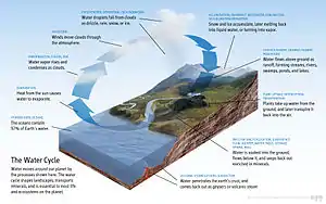
Water vapor generated through surface evaporation is transported by circulatory patterns in the atmosphere. When atmospheric conditions permit an uplift of warm, humid air, this water condenses and falls to the surface as precipitation.[199] Most of the water is then transported to lower elevations by river systems and usually returned to the oceans or deposited into lakes. This water cycle is a vital mechanism for supporting life on land and is a primary factor in the erosion of surface features over geological periods. Precipitation patterns vary widely, ranging from several meters of water per year to less than a millimeter. Atmospheric circulation, topographic features, and temperature differences determine the average precipitation that falls in each region.[208]
The commonly used Köppen climate classification system has five broad groups (humid tropics, arid, humid middle latitudes, continental and cold polar), which are further divided into more specific subtypes.[200] The Köppen system rates regions based on observed temperature and precipitation.[209] Surface air temperature can rise to around 55 °C (131 °F) in hot deserts, such as Death Valley, and can fall as low as −89 °C (−128 °F) in Antarctica.[210][211]
Upper atmosphere

Above the troposphere, the atmosphere is usually divided into the stratosphere, mesosphere, and thermosphere.[196] Each layer has a different lapse rate, defining the rate of change in temperature with height. Beyond these, the exosphere thins out into the magnetosphere, where the geomagnetic fields interact with the solar wind.[212] Within the stratosphere is the ozone layer, a component that partially shields the surface from ultraviolet light and thus is important for life on Earth. The Kármán line, defined as 100 km above Earth's surface, is a working definition for the boundary between the atmosphere and outer space.[213]
Thermal energy causes some of the molecules at the outer edge of the atmosphere to increase their velocity to the point where they can escape from Earth's gravity. This causes a slow but steady loss of the atmosphere into space. Because unfixed hydrogen has a low molecular mass, it can achieve escape velocity more readily, and it leaks into outer space at a greater rate than other gases.[214] The leakage of hydrogen into space contributes to the shifting of Earth's atmosphere and surface from an initially reducing state to its current oxidizing one. Photosynthesis provided a source of free oxygen, but the loss of reducing agents such as hydrogen is thought to have been a necessary precondition for the widespread accumulation of oxygen in the atmosphere.[215] Hence the ability of hydrogen to escape from the atmosphere may have influenced the nature of life that developed on Earth.[216] In the current, oxygen-rich atmosphere most hydrogen is converted into water before it has an opportunity to escape. Instead, most of the hydrogen loss comes from the destruction of methane in the upper atmosphere.[217]
Life on Earth
A planet's life forms inhabit ecosystems, whose total forms the biosphere.[218] The biosphere is divided into a number of biomes, inhabited by broadly similar plants and animals.[219] On land, biomes are separated primarily by differences in latitude, height above sea level and humidity. Terrestrial biomes lying within the Arctic or Antarctic Circles, at high altitudes or in extremely arid areas are relatively barren of plant and animal life; species diversity reaches a peak in humid lowlands at equatorial latitudes.[220] Estimates of the number of species on Earth today vary; most species have not been described.[221]
A planet that can sustain life is termed habitable, even if life did not originate there. Earth provides liquid water—an environment where complex organic molecules can assemble and interact, and sufficient energy to sustain metabolism.[222] Plants can take up nutrients from the atmosphere, soils and water. These nutrients are constantly recycled between different species.[223] The distance of Earth from the Sun, as well as its orbital eccentricity, rate of rotation, axial tilt, geological history, sustaining atmosphere, and magnetic field all contribute to the current climatic conditions at the surface.[224]
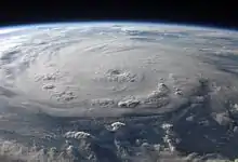
Extreme weather, such as tropical cyclones (including hurricanes and typhoons), occurs over most of Earth's surface and has a large impact on life in those areas. From 1980 to 2000, these events caused an average of 11,800 human deaths per year.[225] Many places are subject to earthquakes, landslides, tsunamis, volcanic eruptions, tornadoes, blizzards, floods, droughts, wildfires, and other calamities and disasters.[226] Human impact is felt in many areas due to pollution of the air and water, acid rain, loss of vegetation (overgrazing, deforestation, desertification), loss of wildlife, species extinction, soil degradation, soil depletion and erosion.[227] There is a scientific consensus that humans are causing global warming by releasing greenhouse gases into the atmosphere.[228] This is driving changes such as the melting of glaciers and ice sheets, a global rise in average sea levels, and significant shifts in weather.[229]
Human geography
Earth's human population passed seven billion in the early 2010s,[231] and is projected to peak at around ten billion in the second half of the 21st century.[232] Most of the growth is expected to take place in sub-Saharan Africa.[232] Human population density varies widely around the world, but a majority live in Asia. By 2050, 68% of the world's population is expected to be living in urban, rather than rural, areas.[233] 68% of the land mass of the world is in the Northern Hemisphere.[234] Partly due to the predominance of land mass, 90% of humans live in the Northern Hemisphere.[235]
It is estimated that one-eighth of Earth's surface is suitable for humans to live on – three-quarters of Earth's surface is covered by oceans, leaving one-quarter as land. Half of that land area is desert (14%),[236] high mountains (27%),[237] or other unsuitable terrains. States claim the planet's entire land surface, except for parts of Antarctica and a few other unclaimed areas. Earth has never had a planetwide government, but the United Nations is the leading worldwide intergovernmental organization.[238][239]
The first human to orbit Earth was Yuri Gagarin on 12 April 1961.[240] In total, about 550 people have visited outer space and reached orbit as of November 2018, and, of these, twelve have walked on the Moon.[241][242] Normally, the only humans in space are those on the International Space Station. The station's crew, made up of six people, is usually replaced every six months.[243] The farthest that humans have traveled from Earth is 400,171 km (248,655 mi), achieved during the Apollo 13 mission in 1970.[244]
Natural resources and land use
| Land use | Percentage |
|---|---|
| Cropland | 12 – 14% |
| Pastures | 30 – 47% |
| Human-used forests | 16 – 27% |
| Infrastructure | 1% |
| Unused land | 24 – 31% |
Earth has resources that have been exploited by humans.[246] Those termed non-renewable resources, such as fossil fuels, only renew over geological timescales.[247] Large deposits of fossil fuels are obtained from Earth's crust, consisting of coal, petroleum, and natural gas.[248] These deposits are used by humans both for energy production and as feedstock for chemical production.[249] Mineral ore bodies have also been formed within the crust through a process of ore genesis, resulting from actions of magmatism, erosion, and plate tectonics.[250] These metals and other elements are extracted by mining, a process which often brings environmental and health damage.[251]
Earth's biosphere produces many useful biological products for humans, including food, wood, pharmaceuticals, oxygen, and the recycling of organic waste. The land-based ecosystem depends upon topsoil and fresh water, and the oceanic ecosystem depends on dissolved nutrients washed down from the land.[252] In 2019, 39 million km2 (15 million sq mi) of Earth's land surface consisted of forest and woodlands, 12 million km2 (4.6 million sq mi) was shrub and grassland, 40 million km2 (15 million sq mi) were used for animal feed production and grazing, and 11 million km2 (4.2 million sq mi) were cultivated as croplands.[253] Of the 12–14% of ice-free land that is used for croplands, 2 percent point was irrigated in 2015.[245] Humans use building materials to construct shelters.[254]
Cultural and historical viewpoint
Human cultures have developed many views of the planet.[255] The standard astronomical symbol of Earth consists of a cross circumscribed by a circle, ![]() ,[256] representing the four corners of the world. Earth is sometimes personified as a deity. In many cultures it is a mother goddess that is also the primary fertility deity.[257] Creation myths in many religions involve the creation of Earth by a supernatural deity or deities.[257] The Gaia Principle, developed mid-20th century, compared Earth's environments and life as a single self-regulating organism leading to broad stabilization of the conditions of habitability.[258][259][260] Images of Earth taken from space, particularly during the Apollo program, have been credited with altering the way that people viewed the planet that they lived on, emphasising its beauty, uniqueness and apparent fragility.[261][262]
,[256] representing the four corners of the world. Earth is sometimes personified as a deity. In many cultures it is a mother goddess that is also the primary fertility deity.[257] Creation myths in many religions involve the creation of Earth by a supernatural deity or deities.[257] The Gaia Principle, developed mid-20th century, compared Earth's environments and life as a single self-regulating organism leading to broad stabilization of the conditions of habitability.[258][259][260] Images of Earth taken from space, particularly during the Apollo program, have been credited with altering the way that people viewed the planet that they lived on, emphasising its beauty, uniqueness and apparent fragility.[261][262]
Scientific investigation has resulted in several culturally transformative shifts in people's view of the planet. Initial belief in a flat Earth was gradually displaced in Ancient Greece by the idea of a spherical Earth, which was attributed to both the philosophers Pythagoras and Parmenides.[263][264] Earth was generally believed to be the center of the universe until the 16th century, when scientists first conclusively demonstrated that it was a moving object, comparable to the other planets in the Solar System.[265]
It was only during the 19th century that geologists realized Earth's age was at least many millions of years.[266] Lord Kelvin used thermodynamics to estimate the age of Earth to be between 20 million and 400 million years in 1864, sparking a vigorous debate on the subject; it was only when radioactivity and radioactive dating were discovered in the late 19th and early 20th centuries that a reliable mechanism for determining Earth's age was established, proving the planet to be billions of years old.[267][268]
See also
Notes
- All astronomical quantities vary, both secularly and periodically. The quantities given are the values at the instant J2000.0 of the secular variation, ignoring all periodic variations.
- aphelion = a × (1 + e); perihelion = a × (1 – e), where a is the semi-major axis and e is the eccentricity. The difference between Earth's perihelion and aphelion is 5 million kilometers.—Wilkinson, John (8 January 2009). Probing the New Solar System. CSIRO Publishing. p. 144. ISBN 978-0-643-09949-4.
- As of 4 January 2018, the United States Strategic Command tracked a total of 18,835 artificial objects, mostly debris. See: Anz-Meador, Phillip; Shoots, Debi, eds. (February 2018). "Satellite Box Score" (PDF). Orbital Debris Quarterly News. 22 (1): 12. Retrieved 18 April 2018.
- Earth's circumference is almost exactly 40,000 km because the metre was calibrated on this measurement—more specifically, 1/10-millionth of the distance between the poles and the equator.
- Due to natural fluctuations, ambiguities surrounding ice shelves, and mapping conventions for vertical datums, exact values for land and ocean coverage are not meaningful. Based on data from the Vector Map and Global Landcover Archived 26 March 2015 at the Wayback Machine datasets, extreme values for coverage of lakes and streams are 0.6% and 1.0% of Earth's surface. The ice sheets of Antarctica and Greenland are counted as land, even though much of the rock that supports them lies below sea level.
- If Earth were shrunk to the size of a billiard ball, some areas of Earth such as large mountain ranges and oceanic trenches would feel like tiny imperfections, whereas much of the planet, including the Great Plains and the abyssal plains, would feel smoother.[93]
- Locally varies between 5 and 200 km.
- Locally varies between 5 and 70 km.
- Including the Somali Plate, which is being formed out of the African Plate. See: Chorowicz, Jean (October 2005). "The East African rift system". Journal of African Earth Sciences. 43 (1–3): 379–410. Bibcode:2005JAfES..43..379C. doi:10.1016/j.jafrearsci.2005.07.019.
- The ultimate source of these figures, uses the term "seconds of UT1" instead of "seconds of mean solar time".—Aoki, S.; Kinoshita, H.; Guinot, B.; Kaplan, G. H.; McCarthy, D. D.; Seidelmann, P. K. (1982). "The new definition of universal time". Astronomy and Astrophysics. 105 (2): 359–61. Bibcode:1982A&A...105..359A.
- For Earth, the Hill radius is , where m is the mass of Earth, a is an astronomical unit, and M is the mass of the Sun. So the radius in AU is about .
- Aphelion is 103.4% of the distance to perihelion. Due to the inverse square law, the radiation at perihelion is about 106.9% the energy at aphelion.


References
- Petsko, Gregory A. (28 April 2011). "The blue marble". Genome Biology. 12 (4): 112. doi:10.1186/gb-2011-12-4-112. PMC 3218853. PMID 21554751.
- "Apollo Imagery – AS17-148-22727". NASA. 1 November 2012. Retrieved 22 October 2020.
- Simon, J.L.; Bretagnon, P.; Chapront, J.; Chapront-Touzé, M.; Francou, G.; Laskar, J. (February 1994). "Numerical expressions for precession formulae and mean elements for the Moon and planets". Astronomy and Astrophysics. 282 (2): 663–83. Bibcode:1994A&A...282..663S.
- Staff (7 August 2007). "Useful Constants". International Earth Rotation and Reference Systems Service. Retrieved 23 September 2008.
- Williams, David R. (16 March 2017). "Earth Fact Sheet". NASA/Goddard Space Flight Center. Retrieved 26 July 2018.
- Allen, Clabon Walter; Cox, Arthur N. (2000). Allen's Astrophysical Quantities. Springer. p. 294. ISBN 978-0-387-98746-0. Retrieved 13 March 2011.
- Park, Ryan S.; Chamberlin, Alan B. "Solar System Dynamics". NASA.
- "UCS Satellite Database". Nuclear Weapons & Global Security. Union of Concerned Scientists. 1 April 2020. Retrieved 25 August 2020.
- Various (2000). David R. Lide (ed.). Handbook of Chemistry and Physics (81st ed.). CRC. ISBN 978-0-8493-0481-1.
- "Selected Astronomical Constants, 2011". The Astronomical Almanac. Archived from the original on 26 August 2013. Retrieved 25 February 2011.
- World Geodetic System (WGS-84). Available online from National Geospatial-Intelligence Agency.
- International Earth Rotation and Reference Systems Service (IERS) Working Group (2004). "General Definitions and Numerical Standards" (PDF). In McCarthy, Dennis D.; Petit, Gérard (eds.). IERS Conventions (2003) (PDF). IERS Technical Note No. 32. Frankfurt am Main: Verlag des Bundesamts für Kartographie und Geodäsie. p. 12. ISBN 978-3-89888-884-4. Retrieved 29 April 2016.
- Humerfelt, Sigurd (26 October 2010). "How WGS 84 defines Earth". Home Online. Archived from the original on 24 April 2011. Retrieved 29 April 2011.
- Pidwirny, Michael (2 February 2006). "Surface area of our planet covered by oceans and continents.(Table 8o-1)". University of British Columbia, Okanagan. Retrieved 26 November 2007.
- Luzum, Brian; Capitaine, Nicole; Fienga, Agnès; Folkner, William; Fukushima, Toshio; et al. (August 2011). "The IAU 2009 system of astronomical constants: The report of the IAU working group on numerical standards for Fundamental Astronomy". Celestial Mechanics and Dynamical Astronomy. 110 (4): 293–304. Bibcode:2011CeMDA.110..293L. doi:10.1007/s10569-011-9352-4.
- The international system of units (SI) (PDF) (2008 ed.). United States Department of Commerce, NIST Special Publication 330. p. 52. Archived from the original (PDF) on 5 February 2009.
- Williams, James G. (1994). "Contributions to the Earth's obliquity rate, precession, and nutation". The Astronomical Journal. 108: 711. Bibcode:1994AJ....108..711W. doi:10.1086/117108. ISSN 0004-6256.
- Allen, Clabon Walter; Cox, Arthur N. (2000). Allen's Astrophysical Quantities. Springer. p. 296. ISBN 978-0-387-98746-0. Retrieved 17 August 2010.
- Arthur N. Cox, ed. (2000). Allen's Astrophysical Quantities (4th ed.). New York: AIP Press. p. 244. ISBN 978-0-387-98746-0. Retrieved 17 August 2010.
- "World: Lowest Temperature". WMO Weather and Climate Extremes Archive. Arizona State University. Retrieved 6 September 2020.
- Kinver, Mark (10 December 2009). "Global average temperature may hit record level in 2010". BBC. Retrieved 22 April 2010.
- "World: Highest Temperature". WMO Weather and Climate Extremes Archive. Arizona State University. Retrieved 6 September 2020.
- "Trends in Atmospheric Carbon Dioxide: Recent Global CO
2 Trend". Earth System Research Laboratory. National Oceanic and Atmospheric Administration. 19 October 2020. Archived from the original on 4 October 2020. - Oxford English Dictionary, 3rd ed. "earth, n.¹" Oxford University Press (Oxford), 2010.
- Simek, Rudolf. Trans. Angela Hall as Dictionary of Northern Mythology, p. 179. D.S. Brewer, 2007. ISBN 978-0-85991-513-7.
- The New Oxford Dictionary of English, 1st ed. "earth". Oxford University Press (Oxford), 1998. ISBN 978-0-19-861263-6.
- "Terra". Oxford English Dictionary (Online ed.). Oxford University Press. (Subscription or participating institution membership required.)
- "Tellus". Oxford English Dictionary (Online ed.). Oxford University Press. (Subscription or participating institution membership required.)
- "Gaia". Oxford English Dictionary (Online ed.). Oxford University Press. (Subscription or participating institution membership required.)
- "Terran". Oxford English Dictionary (Online ed.). Oxford University Press. (Subscription or participating institution membership required.)
- "terrestrial". Oxford English Dictionary (Online ed.). Oxford University Press. (Subscription or participating institution membership required.)
- "terrene". Oxford English Dictionary (Online ed.). Oxford University Press. (Subscription or participating institution membership required.)
- "tellurian". Oxford English Dictionary (Online ed.). Oxford University Press. (Subscription or participating institution membership required.)
- "Telluric". Lexico. Oxford English Dictionary. Retrieved 7 November 2020.
- Bouvier, Audrey; Wadhwa, Meenakshi (September 2010). "The age of the Solar System redefined by the oldest Pb–Pb age of a meteoritic inclusion". Nature Geoscience. 3 (9): 637–641. Bibcode:2010NatGe...3..637B. doi:10.1038/ngeo941.
- See:
- Dalrymple, G.B. (1991). The Age of the Earth. California: Stanford University Press. ISBN 978-0-8047-1569-0.
- Newman, William L. (9 July 2007). "Age of the Earth". Publications Services, USGS. Retrieved 20 September 2007.
- Dalrymple, G. Brent (2001). "The age of the Earth in the twentieth century: a problem (mostly) solved". Geological Society, London, Special Publications. 190 (1): 205–21. Bibcode:2001GSLSP.190..205D. doi:10.1144/GSL.SP.2001.190.01.14. S2CID 130092094. Retrieved 20 September 2007.
- Righter, K.; Schonbachler, M. (7 May 2018). "Ag Isotopic Evolution of the Mantle During Accretion: New Constraints from Pd and Ag Metal-Silicate Partitioning". Differentiation: Building the Internal Architecture of Planets. 2084: 4034. Bibcode:2018LPICo2084.4034R. Retrieved 25 October 2020.
- Tartèse, Romain; Anand, Mahesh; Gattacceca, Jérôme; Joy, Katherine H.; Mortimer, James I.; Pernet-Fisher, John F.; Russell, Sara; Snape, Joshua F.; Weiss, Benjamin P. (2019). "Constraining the Evolutionary History of the Moon and the Inner Solar System: A Case for New Returned Lunar Samples". Space Science Reviews. 215 (8): 54. Bibcode:2019SSRv..215...54T. doi:10.1007/s11214-019-0622-x. ISSN 1572-9672.
- Reilly, Michael (22 October 2009). "Controversial Moon Origin Theory Rewrites History". Archived from the original on 9 January 2010. Retrieved 30 January 2010.
- Canup, R.; Asphaug, E. (2001). "Origin of the Moon in a giant impact near the end of the Earth's formation". Nature. 412 (6848): 708–12. Bibcode:2001Natur.412..708C. doi:10.1038/35089010. PMID 11507633. S2CID 4413525.
- Meier, M. M. M.; Reufer, A.; Wieler, R. (4 August 2014). "On the origin and composition of Theia: Constraints from new models of the Giant Impact" (PDF). Icarus. 242: 5. arXiv:1410.3819. Bibcode:2014Icar..242..316M. doi:10.1016/j.icarus.2014.08.003. S2CID 119226112. Retrieved 25 October 2020.
- Claeys, Philippe; Morbidelli, Alessandro (1 January 2011). "Late Heavy Bombardment". In Gargaud, Muriel; Amils, Prof Ricardo; Quintanilla, José Cernicharo; Cleaves II, Henderson James (Jim); Irvine, William M.; Pinti, Prof Daniele L.; Viso, Michel (eds.). Encyclopedia of Astrobiology. Springer Berlin Heidelberg. pp. 909–912. doi:10.1007/978-3-642-11274-4_869. ISBN 978-3-642-11271-3.
- "Earth's Early Atmosphere and Oceans". Lunar and Planetary Institute. Universities Space Research Association. Retrieved 27 June 2019.
- Morbidelli, A.; et al. (2000). "Source regions and time scales for the delivery of water to Earth". Meteoritics & Planetary Science. 35 (6): 1309–20. Bibcode:2000M&PS...35.1309M. doi:10.1111/j.1945-5100.2000.tb01518.x.
- Piani, Laurette; Marrocchi, Yves; Rigaudier, Thomas; Vacher, Lionel G.; Thomassin, Dorian; Marty, Bernard (2020). "Earth's water may have been inherited from material similar to enstatite chondrite meteorites". Science. 369 (6507): 1110–1113. Bibcode:2020Sci...369.1110P. doi:10.1126/science.aba1948. ISSN 0036-8075. PMID 32855337. S2CID 221342529.
- Guinan, E. F.; Ribas, I. (2002). Benjamin Montesinos, Alvaro Gimenez and Edward F. Guinan (ed.). Our Changing Sun: The Role of Solar Nuclear Evolution and Magnetic Activity on Earth's Atmosphere and Climate. ASP Conference Proceedings: The Evolving Sun and its Influence on Planetary Environments. San Francisco: Astronomical Society of the Pacific. Bibcode:2002ASPC..269...85G. ISBN 978-1-58381-109-2.
- Staff (4 March 2010). "Oldest measurement of Earth's magnetic field reveals battle between Sun and Earth for our atmosphere". Phys.org. Retrieved 27 March 2010.
- Harrison, T.; et al. (December 2005). "Heterogeneous Hadean hafnium: evidence of continental crust at 4.4 to 4.5 ga". Science. 310 (5756): 1947–50. Bibcode:2005Sci...310.1947H. doi:10.1126/science.1117926. PMID 16293721. S2CID 11208727.
- Rogers, John James William; Santosh, M. (2004). Continents and Supercontinents. Oxford University Press US. p. 48. ISBN 978-0-19-516589-0.
- Hurley, P. M.; Rand, J. R. (June 1969). "Pre-drift continental nuclei". Science. 164 (3885): 1229–42. Bibcode:1969Sci...164.1229H. doi:10.1126/science.164.3885.1229. PMID 17772560.
- Armstrong, R. L. (1991). "The persistent myth of crustal growth" (PDF). Australian Journal of Earth Sciences. 38 (5): 613–30. Bibcode:1991AuJES..38..613A. CiteSeerX 10.1.1.527.9577. doi:10.1080/08120099108727995.
- De Smet, J.; Van Den Berg, A.P.; Vlaar, N.J. (2000). "Early formation and long-term stability of continents resulting from decompression melting in a convecting mantle" (PDF). Tectonophysics. 322 (1–2): 19–33. Bibcode:2000Tectp.322...19D. doi:10.1016/S0040-1951(00)00055-X. hdl:1874/1653.
- Dhuime, B.; Hawksworth, C.J.; Delavault, H.; Cawood, P.A. (2018). "Rates of generation and destruction of the continental crust: implications for continental growth". Philos Trans a Math Phys Eng Sci. 376 (2132). Bibcode:2018RSPTA.37670403D. doi:10.1098/rsta.2017.0403. PMC 6189557. PMID 30275156.
- Bradley, D.C. (2011). "Secular Trends in the Geologic Record and the Supercontinent Cycle". Earth-Science Reviews. 108 (1–2): 16–33. Bibcode:2011ESRv..108...16B. CiteSeerX 10.1.1.715.6618. doi:10.1016/j.earscirev.2011.05.003.
- Kinzler, Ro. "When and how did the ice age end? Could another one start?". American Museum of Natural History. Retrieved 27 June 2019.
- Chalk, Thomas B.; Hain, Mathis P.; Foster, Gavin L.; Rohling, Eelco J.; Sexton, Philip F.; Badger, Marcus P. S.; Cherry, Soraya G.; Hasenfratz, Adam P.; Haug, Gerald H.; Jaccard, Samuel L.; Martínez-García, Alfredo; Pälike, Heiko; Pancost, Richard D.; Wilson, Paul A. (12 December 2007). "Causes of ice age intensification across the Mid-Pleistocene Transition" (PDF). Proc Natl Acad Sci U S A. 114 (50): 13114–13119. doi:10.1073/pnas.1702143114. PMC 5740680. PMID 29180424. Retrieved 28 June 2019.
- Staff. "Paleoclimatology – The Study of Ancient Climates". Page Paleontology Science Center. Archived from the original on 4 March 2007. Retrieved 2 March 2007.
- Turner, Chris S.M.; et al. (2010). "The potential of New Zealand kauri (Agathis australis) for testing the synchronicity of abrupt climate change during the Last Glacial Interval (60,000–11,700 years ago)". Quaternary Science Reviews. Elsevier. 29 (27–28): 3677-3682. Bibcode:2010QSRv...29.3677T. doi:10.1016/j.quascirev.2010.08.017. Retrieved 3 November 2020.
- Doolittle, W. Ford; Worm, Boris (February 2000). "Uprooting the tree of life" (PDF). Scientific American. 282 (6): 90–95. Bibcode:2000SciAm.282b..90D. doi:10.1038/scientificamerican0200-90. PMID 10710791. Archived from the original (PDF) on 15 July 2011.
- Zimmer, Carl (3 October 2013). "Earth's Oxygen: A Mystery Easy to Take for Granted". The New York Times. Retrieved 3 October 2013.
- Berkner, L. V.; Marshall, L. C. (1965). "On the Origin and Rise of Oxygen Concentration in the Earth's Atmosphere". Journal of the Atmospheric Sciences. 22 (3): 225–61. Bibcode:1965JAtS...22..225B. doi:10.1175/1520-0469(1965)022<0225:OTOARO>2.0.CO;2.
- Burton, Kathleen (29 November 2002). "Astrobiologists Find Evidence of Early Life on Land". NASA. Retrieved 5 March 2007.
- Noffke, Nora; Christian, Daniel; Wacey, David; Hazen, Robert M. (8 November 2013). "Microbially Induced Sedimentary Structures Recording an Ancient Ecosystem in the ca. 3.48 Billion-Year-Old Dresser Formation, Pilbara, Western Australia". Astrobiology. 13 (12): 1103–24. Bibcode:2013AsBio..13.1103N. doi:10.1089/ast.2013.1030. PMC 3870916. PMID 24205812.
- Ohtomo, Yoko; Kakegawa, Takeshi; Ishida, Akizumi; et al. (January 2014). "Evidence for biogenic graphite in early Archaean Isua metasedimentary rocks". Nature Geoscience. 7 (1): 25–28. Bibcode:2014NatGe...7...25O. doi:10.1038/ngeo2025. ISSN 1752-0894. S2CID 54767854.
- Borenstein, Seth (19 October 2015). "Hints of life on what was thought to be desolate early Earth". Excite. Yonkers, NY: Mindspark Interactive Network. Associated Press. Archived from the original on 18 August 2016. Retrieved 20 October 2015.
- Bell, Elizabeth A.; Boehnike, Patrick; Harrison, T. Mark; et al. (19 October 2015). "Potentially biogenic carbon preserved in a 4.1 billion-year-old zircon" (PDF). Proc. Natl. Acad. Sci. U.S.A. 112 (47): 14518–21. Bibcode:2015PNAS..11214518B. doi:10.1073/pnas.1517557112. ISSN 1091-6490. PMC 4664351. PMID 26483481. Retrieved 20 October 2015. Early edition, published online before print.
- Tyrell, Kelly April (18 December 2017). "Oldest fossils ever found show life on Earth began before 3.5 billion years ago". University of Wisconsin–Madison. Retrieved 18 December 2017.
- Schopf, J. William; Kitajima, Kouki; Spicuzza, Michael J.; Kudryavtsev, Anatolly B.; Valley, John W. (2017). "SIMS analyses of the oldest known assemblage of microfossils document their taxon-correlated carbon isotope compositions". PNAS. 115 (1): 53–58. Bibcode:2018PNAS..115...53S. doi:10.1073/pnas.1718063115. PMC 5776830. PMID 29255053.
- Brooke, John L. (17 March 2014). Climate Change and the Course of Global History. Cambridge University Press. p. 42. ISBN 978-0-521-87164-8.
- Cabej, Nelson R. (12 October 2019). Epigenetic Mechanisms of the Cambrian Explosion. Elsevier Science. p. 56. ISBN 978-0-12-814312-4.
- Raup, D. M.; Sepkoski Jr, J. J. (1982). "Mass Extinctions in the Marine Fossil Record". Science. 215 (4539): 1501–03. Bibcode:1982Sci...215.1501R. doi:10.1126/science.215.4539.1501. PMID 17788674. S2CID 43002817.
- Stanley, S. M. (2016). "Estimates of the magnitudes of major marine mass extinctions in earth history". Proceedings of the National Academy of Sciences of the United States of America. 113 (42): E6325–E6334. Bibcode:2016PNAS..113E6325S. doi:10.1073/pnas.1613094113. PMC 5081622. PMID 27698119. S2CID 23599425.
- Gould, Stephan J. (October 1994). "The Evolution of Life on Earth". Scientific American. 271 (4): 84–91. Bibcode:1994SciAm.271d..84G. doi:10.1038/scientificamerican1094-84. PMID 7939569. Retrieved 5 March 2007.
- Wilkinson, B. H.; McElroy, B. J. (2007). "The impact of humans on continental erosion and sedimentation". Bulletin of the Geological Society of America. 119 (1–2): 140–56. Bibcode:2007GSAB..119..140W. doi:10.1130/B25899.1. S2CID 128776283.
- Novacek, Michael J. (8 November 2014). "Prehistory's Brilliant Future". The New York Times. Retrieved 1 November 2020.
- Jablonski, D. (2004). "Extinction: past and present". Nature. 427 (6975): 589. doi:10.1038/427589a. PMID 14961099. S2CID 4412106.
- Ganopolski, A.; Winkelmann, R.; Schellnhuber, H. J. (2016). "Critical insolation–CO2 relation for diagnosing past and future glacial inception". Nature. 529 (7585): 200–203. Bibcode:2016Natur.529..200G. doi:10.1038/nature16494. ISSN 1476-4687. PMID 26762457. S2CID 4466220.
- Sackmann, I.-J.; Boothroyd, A. I.; Kraemer, K. E. (1993). "Our Sun. III. Present and Future". Astrophysical Journal. 418: 457–68. Bibcode:1993ApJ...418..457S. doi:10.1086/173407.
- Britt, Robert (25 February 2000). "Freeze, Fry or Dry: How Long Has the Earth Got?". Archived from the original on 5 June 2009.
- Li, King-Fai; Pahlevan, Kaveh; Kirschvink, Joseph L.; Yung, Yuk L. (2009). "Atmospheric pressure as a natural climate regulator for a terrestrial planet with a biosphere" (PDF). Proceedings of the National Academy of Sciences. 106 (24): 9576–79. Bibcode:2009PNAS..106.9576L. doi:10.1073/pnas.0809436106. PMC 2701016. PMID 19487662. Retrieved 19 July 2009.
- Ward, Peter D.; Brownlee, Donald (2002). The Life and Death of Planet Earth: How the New Science of Astrobiology Charts the Ultimate Fate of Our World. New York: Times Books, Henry Holt and Company. ISBN 978-0-8050-6781-1.
- Mello, Fernando de Sousa; Friaça, Amâncio César Santos (2020). "The end of life on Earth is not the end of the world: converging to an estimate of life span of the biosphere?". International Journal of Astrobiology. 19 (1): 25–42. Bibcode:2020IJAsB..19...25D. doi:10.1017/S1473550419000120. ISSN 1473-5504.
- Bounama, Christine; Franck, S.; Von Bloh, W. (2001). "The fate of Earth's ocean". Hydrology and Earth System Sciences. 5 (4): 569–75. Bibcode:2001HESS....5..569B. doi:10.5194/hess-5-569-2001. S2CID 14024675.
- Schröder, K.-P.; Connon Smith, Robert (2008). "Distant future of the Sun and Earth revisited". Monthly Notices of the Royal Astronomical Society. 386 (1): 155–63. arXiv:0801.4031. Bibcode:2008MNRAS.386..155S. doi:10.1111/j.1365-2966.2008.13022.x. S2CID 10073988.
See also Palmer, Jason (22 February 2008). "Hope dims that Earth will survive Sun's death". NewScientist.com news service. Archived from the original on 15 April 2012. Retrieved 24 March 2008. - "Tall Tales about Highest Peaks". ABC Science. 16 April 2004. Retrieved 29 May 2019.
- Milbert, D. G.; Smith, D. A. "Converting GPS Height into NAVD88 Elevation with the GEOID96 Geoid Height Model". National Geodetic Survey, NOAA. Retrieved 7 March 2007.
- Sandwell, D. T.; Smith, W. H. F. (7 July 2006). "Exploring the Ocean Basins with Satellite Altimeter Data". NOAA/NGDC. Archived from the original on 15 July 2014. Retrieved 21 April 2007.
- Senne, Joseph H. (2000). "Did Edmund Hillary Climb the Wrong Mountain". Professional Surveyor. 20 (5): 16–21.
- Sharp, David (5 March 2005). "Chimborazo and the old kilogram". The Lancet. 365 (9462): 831–32. doi:10.1016/S0140-6736(05)71021-7. PMID 15752514. S2CID 41080944.
- Krulwich, Robert (7 April 2007). "The 'Highest' Spot on Earth". NPR. Retrieved 31 July 2012.
- Stewart, Heather A.; Jamieson, Alan J. (2019). "The five deeps: The location and depth of the deepest place in each of the world's oceans". Earth-Science Reviews. 197: 102896. Bibcode:2019ESRv..19702896S. doi:10.1016/j.earscirev.2019.102896. ISSN 0012-8252.
- "Is a Pool Ball Smoother than the Earth?" (PDF). Billiards Digest. 1 June 2013. Retrieved 26 November 2014.
- Tewksbury, Barbara. "Back-of-the-Envelope Calculations: Scale of the Himalayas". Carleton University. Retrieved 19 October 2020.
- "What is the geoid?". National Ocean Service. Retrieved 10 October 2020.
- Rudnick, R. L.; Gao, S. (2003). "Composition of the Continental Crust". In Holland, H. D.; Turekian, K. K. (eds.). Treatise on Geochemistry. Treatise on Geochemistry. 3. New York: Elsevier Science. pp. 1–64. Bibcode:2003TrGeo...3....1R. doi:10.1016/B0-08-043751-6/03016-4. ISBN 978-0-08-043751-4.
- White, W. M.; Klein, E. M. (2014). "Composition of the Oceanic Crust". In Holland, H. D.; Turekian, K. K. (eds.). Treatise on Geochemistry. 4. New York: Elsevier Science. pp. 457–496. doi:10.1016/B978-0-08-095975-7.00315-6. hdl:10161/8301. ISBN 978-0-08-098300-4.
- Morgan, J. W.; Anders, E. (1980). "Chemical composition of Earth, Venus, and Mercury". Proceedings of the National Academy of Sciences. 77 (12): 6973–77. Bibcode:1980PNAS...77.6973M. doi:10.1073/pnas.77.12.6973. PMC 350422. PMID 16592930.
- Brown, Geoff C.; Mussett, Alan E. (1981). The Inaccessible Earth (2nd ed.). Taylor & Francis. p. 166. ISBN 978-0-04-550028-4. Note: After Ronov and Yaroshevsky (1969).
- Jordan, T. H. (1979). "Structural geology of the Earth's interior". Proceedings of the National Academy of Sciences of the United States of America. 76 (9): 4192–4200. Bibcode:1979PNAS...76.4192J. doi:10.1073/pnas.76.9.4192. PMC 411539. PMID 16592703.
- Robertson, Eugene C. (26 July 2001). "The Interior of the Earth". USGS. Retrieved 24 March 2007.
- "The Crust and Lithosphere". London Geological Society. 2012. Retrieved 25 October 2020.
- Micalizio, Caryl-Sue; Evers, Jeannie (20 May 2015). "Lithosphere". National Geographic. Retrieved 13 October 2020.
- Tanimoto, Toshiro (1995). "Crustal Structure of the Earth" (PDF). In Thomas J. Ahrens (ed.). Global Earth Physics: A Handbook of Physical Constants. Global Earth Physics: A Handbook of Physical Constants. Washington, DC: American Geophysical Union. Bibcode:1995geph.conf.....A. ISBN 978-0-87590-851-9. Archived from the original (PDF) on 16 October 2006. Retrieved 3 February 2007.
- Deuss, A. (2014). "Heterogeneity and Anisotropy of Earth's Inner Core" (PDF). Annu. Rev. Earth Planet. Sci. 42 (1): 103–126. Bibcode:2014AREPS..42..103D. doi:10.1146/annurev-earth-060313-054658.
- Sanders, Robert (10 December 2003). "Radioactive potassium may be major heat source in Earth's core". UC Berkeley News. Retrieved 28 February 2007.
- "The Earth's Centre is 1000 Degrees Hotter than Previously Thought". The European Synchrotron (ESRF). 25 April 2013. Archived from the original on 28 June 2013. Retrieved 12 April 2015.
- Alfè, D.; Gillan, M. J.; Vocadlo, L.; Brodholt, J.; Price, G. D. (2002). "The ab initio simulation of the Earth's core" (PDF). Philosophical Transactions of the Royal Society. 360 (1795): 1227–44. Bibcode:2002RSPTA.360.1227A. doi:10.1098/rsta.2002.0992. PMID 12804276. S2CID 21132433. Retrieved 28 February 2007.
- Turcotte, D. L.; Schubert, G. (2002). "4". Geodynamics (2 ed.). Cambridge, England, UK: Cambridge University Press. p. 137. ISBN 978-0-521-66624-4.
- Vlaar, N; Vankeken, P.; Vandenberg, A. (1994). "Cooling of the Earth in the Archaean: Consequences of pressure-release melting in a hotter mantle" (PDF). Earth and Planetary Science Letters. 121 (1–2): 1–18. Bibcode:1994E&PSL.121....1V. doi:10.1016/0012-821X(94)90028-0. Archived from the original (PDF) on 19 March 2012.
- Pollack, Henry N.; Hurter, Suzanne J.; Johnson, Jeffrey R. (August 1993). "Heat flow from the Earth's interior: Analysis of the global data set". Reviews of Geophysics. 31 (3): 267–80. Bibcode:1993RvGeo..31..267P. doi:10.1029/93RG01249.
- Richards, M. A.; Duncan, R. A.; Courtillot, V. E. (1989). "Flood Basalts and Hot-Spot Tracks: Plume Heads and Tails". Science. 246 (4926): 103–07. Bibcode:1989Sci...246..103R. doi:10.1126/science.246.4926.103. PMID 17837768. S2CID 9147772.
- Sclater, John G; Parsons, Barry; Jaupart, Claude (1981). "Oceans and Continents: Similarities and Differences in the Mechanisms of Heat Loss". Journal of Geophysical Research. 86 (B12): 11535. Bibcode:1981JGR....8611535S. doi:10.1029/JB086iB12p11535.
- Brown, W. K.; Wohletz, K. H. (2005). "SFT and the Earth's Tectonic Plates". Los Alamos National Laboratory. Retrieved 2 March 2007.
- Kious, W. J.; Tilling, R. I. (5 May 1999). "Understanding plate motions". USGS. Retrieved 2 March 2007.
- Seligman, Courtney (2008). "The Structure of the Terrestrial Planets". Online Astronomy eText Table of Contents. cseligman.com. Retrieved 28 February 2008.
- Duennebier, Fred (12 August 1999). "Pacific Plate Motion". University of Hawaii. Retrieved 14 March 2007.
- Mueller, R. D.; et al. (7 March 2007). "Age of the Ocean Floor Poster". NOAA. Retrieved 14 March 2007.
- Bowring, Samuel A.; Williams, Ian S. (1999). "Priscoan (4.00–4.03 Ga) orthogneisses from northwestern Canada". Contributions to Mineralogy and Petrology. 134 (1): 3–16. Bibcode:1999CoMP..134....3B. doi:10.1007/s004100050465. S2CID 128376754.
- Meschede, Martin; Barckhausen, Udo (20 November 2000). "Plate Tectonic Evolution of the Cocos-Nazca Spreading Center". Proceedings of the Ocean Drilling Program. Texas A&M University. Retrieved 2 April 2007.
- Argus, D.F.; Gordon, R.G.; DeMets, C. (2011). "Geologically current motion of 56 plates relative to the no‐net‐rotation reference frame". Geochemistry, Geophysics, Geosystems. 12 (11): n/a. Bibcode:2011GGG....1211001A. doi:10.1029/2011GC003751.
- "World Factbook". Cia.gov. Retrieved 2 November 2012.
- Center, National Geophysical Data. "Hypsographic Curve of Earth's Surface from ETOPO1". ngdc.noaa.gov.
- Staff. "Layers of the Earth". Volcano World. Oregon State University. Archived from the original on 11 February 2013. Retrieved 11 March 2007.
- Jessey, David. "Weathering and Sedimentary Rocks". Cal Poly Pomona. Archived from the original on 3 July 2007. Retrieved 20 March 2007.
- de Pater, Imke; Lissauer, Jack J. (2010). Planetary Sciences (2nd ed.). Cambridge University Press. p. 154. ISBN 978-0-521-85371-2.
- Wenk, Hans-Rudolf; Bulakh, Andreĭ Glebovich (2004). Minerals: their constitution and origin. Cambridge University Press. p. 359. ISBN 978-0-521-52958-7.
- Kring, David A. "Terrestrial Impact Cratering and Its Environmental Effects". Lunar and Planetary Laboratory. Retrieved 22 March 2007.
- Martin, Ronald (2011). Earth's Evolving Systems: The History of Planet Earth. Jones & Bartlett Learning. ISBN 978-0-7637-8001-2.
- "World Bank arable land". World Bank. Retrieved 19 October 2015.
- "World Bank permanent cropland". World Bank. Retrieved 19 October 2015.
- Hooke, Roger LeB.; Martín-Duque, José F.; Pedraza, Javier (December 2012). "Land transformation by humans: A review" (PDF). GSA Today. 22 (12): 4–10. doi:10.1130/GSAT151A.1.
- Watts, A. B.; Daly, S. F. (May 1981). "Long wavelength gravity and topography anomalies". Annual Review of Earth and Planetary Sciences. 9: 415–18. Bibcode:1981AREPS...9..415W. doi:10.1146/annurev.ea.09.050181.002215.
- Olson, Peter; Amit, Hagay (2006), "Changes in earth's dipole" (PDF), Naturwissenschaften, 93 (11): 519–542, Bibcode:2006NW.....93..519O, doi:10.1007/s00114-006-0138-6, PMID 16915369, S2CID 22283432
- Fitzpatrick, Richard (16 February 2006). "MHD dynamo theory". NASA WMAP. Retrieved 27 February 2007.
- Campbell, Wallace Hall (2003). Introduction to Geomagnetic Fields. New York: Cambridge University Press. p. 57. ISBN 978-0-521-82206-0.
- Ganushkina, N. Yu; Liemohn, M. W.; Dubyagin, S. (2018). "Current Systems in the Earth's Magnetosphere". Reviews of Geophysics. 56 (2): 309–332. Bibcode:2018RvGeo..56..309G. doi:10.1002/2017RG000590. hdl:2027.42/145256. ISSN 1944-9208.
- Masson, Arnaud (11 May 2007). "Cluster reveals the reformation of the Earth's bow shock". European Space Agency. Retrieved 16 August 2016.
- Gallagher, Dennis L. (14 August 2015). "The Earth's Plasmasphere". NASA/Marshall Space Flight Center. Retrieved 16 August 2016.
- Gallagher, Dennis L. (27 May 2015). "How the Plasmasphere is Formed". NASA/Marshall Space Flight Center. Retrieved 16 August 2016.
- Baumjohann, Wolfgang; Treumann, Rudolf A. (1997). Basic Space Plasma Physics. World Scientific. pp. 8, 31. ISBN 978-1-86094-079-8.
- McElroy, Michael B. (2012). "Ionosphere and magnetosphere". Encyclopædia Britannica. Encyclopædia Britannica, Inc.
- Van Allen, James Alfred (2004). Origins of Magnetospheric Physics. University of Iowa Press. ISBN 978-0-87745-921-7. OCLC 646887856.
- Stern, David P. (8 July 2005). "Exploration of the Earth's Magnetosphere". NASA. Retrieved 21 March 2007.
- McCarthy, Dennis D.; Hackman, Christine; Nelson, Robert A. (November 2008). "The Physical Basis of the Leap Second" (PDF). The Astronomical Journal. 136 (5): 1906–08. Bibcode:2008AJ....136.1906M. doi:10.1088/0004-6256/136/5/1906. Archived from the original (PDF) on 28 July 2018.
- "Leap seconds". Time Service Department, USNO. Archived from the original on 12 March 2015. Retrieved 23 September 2008.
- "Rapid Service/Prediction of Earth Orientation". IERS Bulletin-A. 28 (15). 9 April 2015. Archived from the original (.DAT file (displays as plaintext in browser)) on 14 March 2015. Retrieved 12 April 2015.
- Seidelmann, P. Kenneth (1992). Explanatory Supplement to the Astronomical Almanac. Mill Valley, CA: University Science Books. p. 48. ISBN 978-0-935702-68-2.
- Zeilik, M.; Gregory, S. A. (1998). Introductory Astronomy & Astrophysics (4th ed.). Saunders College Publishing. p. 56. ISBN 978-0-03-006228-5.
- Williams, David R. (10 February 2006). "Planetary Fact Sheets". NASA. Retrieved 28 September 2008.—See the apparent diameters on the Sun and Moon pages.
- Staff (12 February 2020). "Pale Blue Dot Revisited". NASA. Retrieved 12 February 2020.
- Williams, David R. (1 September 2004). "Moon Fact Sheet". NASA. Retrieved 21 March 2007.
- Vázquez, M.; Rodríguez, P. Montañés; Palle, E. (2006). "The Earth as an Object of Astrophysical Interest in the Search for Extrasolar Planets" (PDF). Lecture Notes and Essays in Astrophysics. 2: 49. Bibcode:2006LNEA....2...49V. Archived from the original (PDF) on 22 August 2011. Retrieved 21 March 2007.
- Astrophysicist team (1 December 2005). "Earth's location in the Milky Way". NASA. Archived from the original on 1 July 2008. Retrieved 11 June 2008.
- Rohli, Robert. V.; Vega, Anthony J. (2018). Climatology (fourth ed.). Jones & Bartlett Learning. pp. 291–292. ISBN 978-1-284-12656-3.
- Burn, Chris (March 1996). The Polar Night (PDF). The Aurora Research Institute. Retrieved 28 September 2015.
- "Sunlight Hours". Australian Antarctic Programme. 24 June 2020. Retrieved 13 October 2020.
- Bromberg, Irv (1 May 2008). "The Lengths of the Seasons (on Earth)". University of Toronto. Archived from the original on 18 December 2008. Retrieved 8 November 2008.
- Lin, Haosheng (2006). "Animation of precession of moon orbit". Survey of Astronomy AST110-6. University of Hawaii at Manoa. Retrieved 10 September 2010.
- Fisher, Rick (5 February 1996). "Earth Rotation and Equatorial Coordinates". National Radio Astronomy Observatory. Retrieved 21 March 2007.
- Buis, Alan (27 February 2020). "Milankovitch (Orbital) Cycles and Their Role in Earth's Climate". NASA. Retrieved 27 October 2020.
- Kang, Sarah M.; Seager, Richard. "Croll Revisited: Why is the Northern Hemisphere Warmer than the Southern Hemisphere?" (PDF). Columbia University. New York City. Retrieved 27 October 2020.
- Klemetti, Erik (17 June 2019). "What's so special about our Moon, anyway?". Astronomy. Retrieved 13 October 2020.
- "Charon". NASA. 19 December 2019. Retrieved 13 October 2020.
- Brown, Toby (2 December 2019). "Curious Kids: Why is the moon called the moon?". The Conversation. Retrieved 13 October 2020.
- Coughenour, Christopher L.; Archer, Allen W.; Lacovara, Kenneth J. (2009). "Tides, tidalites, and secular changes in the Earth–Moon system". Earth-Science Reviews. 97 (1): 59–79. Bibcode:2009ESRv...97...59C. doi:10.1016/j.earscirev.2009.09.002. ISSN 0012-8252.
- Kelley, Peter (17 August 2017). "Tidally locked exoplanets may be more common than previously thought". University of Washington News. Retrieved 8 October 2020.
- "Lunar Phases and Eclipses | Earth's Moon". NASA Solar System Exploration. Retrieved 8 October 2020.
- Espenak, F.; Meeus, J. (7 February 2007). "Secular acceleration of the Moon". NASA. Archived from the original on 2 March 2008. Retrieved 20 April 2007.
- Williams, G.E. (2000). "Geological constraints on the Precambrian history of Earth's rotation and the Moon's orbit". Reviews of Geophysics. 38 (1): 37–59. Bibcode:2000RvGeo..38...37W. doi:10.1029/1999RG900016.
- Laskar, J.; et al. (2004). "A long-term numerical solution for the insolation quantities of the Earth". Astronomy and Astrophysics. 428 (1): 261–85. Bibcode:2004A&A...428..261L. doi:10.1051/0004-6361:20041335.
- Cooper, Keith (27 January 2015). "Earth's moon may not be critical to life". Phys.org. Retrieved 26 October 2020.
- Dadarich, Amy; Mitrovica, Jerry X.; Matsuyama, Isamu; Perron, J. Taylor; Manga, Michael; Richards, Mark A. (22 November 2007). "Equilibrium rotational stability and figure of Mars" (PDF). Icarus. 194 (2): 463–475. doi:10.1016/j.icarus.2007.10.017. Retrieved 26 October 2020.
- Sharf, Caleb A. (18 May 2012). "The Solar Eclipse Coincidence". Scientific American. Retrieved 13 October 2020.
- Christou, Apostolos A.; Asher, David J. (31 March 2011). "A long-lived horseshoe companion to the Earth". Monthly Notices of the Royal Astronomical Society. 414 (4): 2965–2969. arXiv:1104.0036. Bibcode:2011MNRAS.414.2965C. doi:10.1111/j.1365-2966.2011.18595.x. S2CID 13832179. See table 2, p. 5.
- Marcos, C. de la Fuente; Marcos, R. de la Fuente (8 August 2016). "Asteroid (469219) 2016 HO3, the smallest and closest Earth quasi-satellite". Monthly Notices of the Royal Astronomical Society. 462 (4): 3441-3456. arXiv:1608.01518. Bibcode:2016MNRAS.462.3441D. doi:10.1093/mnras/stw1972. S2CID 118580771. Retrieved 28 October 2020.
- Connors, Martin; Wiegert, Paul; Veillet, Christian (27 July 2011). "Earth's Trojan asteroid". Nature. 475 (7357): 481–83. Bibcode:2011Natur.475..481C. doi:10.1038/nature10233. PMID 21796207. S2CID 205225571.
- Choi, Charles Q. (27 July 2011). "First Asteroid Companion of Earth Discovered at Last". Space.com. Retrieved 27 July 2011.
- "2006 RH120 ( = 6R10DB9) (A second moon for the Earth?)". Great Shefford Observatory. Great Shefford Observatory. Archived from the original on 6 February 2015. Retrieved 17 July 2015.
- Welch, Rosanne; Lamphier, Peg A. (22 February 2019). Technical Innovation in American History: An Encyclopedia of Science and Technology [3 volumes]. ABC-CLIO. p. 126. ISBN 978-1-61069-094-2.
- Charette, Matthew A.; Smith, Walter H. F. (June 2010). "The Volume of Earth's Ocean" (PDF). Oceanography. 23 (2): 112–14. doi:10.5670/oceanog.2010.51. Archived from the original (PDF) on 2 November 2013. Retrieved 6 June 2013.
- "Third rock from the Sun – restless Earth". NASA's Cosmos. Retrieved 12 April 2015.
- "On Water". European Investment Bank. Retrieved 7 December 2020.
- Khokhar, Tariq (22 March 2017). "Chart: Globally, 70% of Freshwater is Used for Agriculture". World Bank Blogs. Retrieved 7 December 2020.
- Perlman, Howard (17 March 2014). "The World's Water". USGS Water-Science School. Retrieved 12 April 2015.
- Hendrix, Mark (2019). Earth Science: An Introduction. Bosten: Cengage. p. 330. ISBN 978-0-357-11656-2.
- Hendrix, Mark (2019). Earth Science: An Introduction. Bosten: Cengage. p. 329. ISBN 978-0-357-11656-2.
- Kennish, Michael J. (2001). Practical handbook of marine science. Marine science series (3rd ed.). CRC Press. p. 35. ISBN 978-0-8493-2391-1.
- Mullen, Leslie (11 June 2002). "Salt of the Early Earth". NASA Astrobiology Magazine. Archived from the original on 30 June 2007. Retrieved 14 March 2007.
- Morris, Ron M. "Oceanic Processes". NASA Astrobiology Magazine. Archived from the original on 15 April 2009. Retrieved 14 March 2007.
- Scott, Michon (24 April 2006). "Earth's Big heat Bucket". NASA Earth Observatory. Retrieved 14 March 2007.
- Sample, Sharron (21 June 2005). "Sea Surface Temperature". NASA. Archived from the original on 27 April 2013. Retrieved 21 April 2007.
- Exline, Joseph D.; Levine, Arlene S.; Levine, Joel S. (2006). Meteorology: An Educator's Resource for Inquiry-Based Learning for Grades 5–9 (PDF). NASA/Langley Research Center. p. 6. NP-2006-08-97-LaRC.
- Geerts, B.; Linacre, E. (November 1997). "The height of the tropopause". Resources in Atmospheric Sciences. University of Wyoming. Retrieved 10 August 2006.
- Harrison, Roy M.; Hester, Ronald E. (2002). Causes and Environmental Implications of Increased UV-B Radiation. Royal Society of Chemistry. ISBN 978-0-85404-265-4.
- Staff (8 October 2003). "Earth's Atmosphere". NASA. Retrieved 21 March 2007.
- Pidwirny, Michael (2006). "Fundamentals of Physical Geography (2nd Edition)". University of British Columbia, Okanagan. Retrieved 19 March 2007.
- Gaan, Narottam (2008). Climate Change and International Politics. Kalpaz Publications. p. 40. ISBN 978-81-7835-641-9.
- Moran, Joseph M. (2005). "Weather". World Book Online Reference Center. NASA/World Book, Inc. Archived from the original on 13 December 2010. Retrieved 17 March 2007.
- Berger, Wolfgang H. (2002). "The Earth's Climate System". University of California, San Diego. Retrieved 24 March 2007.
- Rahmstorf, Stefan (2003). "The Thermohaline Ocean Circulation". Potsdam Institute for Climate Impact Research. Retrieved 21 April 2007.
- Sadava, David E.; Heller, H. Craig; Orians, Gordon H. (2006). Life, the Science of Biology (8th ed.). MacMillan. p. 1114. ISBN 978-0-7167-7671-0.
- Staff. "Climate Zones". UK Department for Environment, Food and Rural Affairs. Archived from the original on 8 August 2010. Retrieved 24 March 2007.
- Rohli, Robert. V.; Vega, Anthony J. (2018). Climatology (fourth ed.). Jones & Bartlett Learning. p. 49. ISBN 978-1-284-12656-3.
- Rohli, Robert. V.; Vega, Anthony J. (2018). Climatology (fourth ed.). Jones & Bartlett Learning. p. 32. ISBN 978-1-284-12656-3.
- Rohli, Robert. V.; Vega, Anthony J. (2018). Climatology (fourth ed.). Jones & Bartlett Learning. p. 34. ISBN 978-1-284-12656-3.
- Rohli, Robert. V.; Vega, Anthony J. (2018). Climatology (fourth ed.). Jones & Bartlett Learning. p. 46. ISBN 978-1-284-12656-3.
- Various (21 July 1997). "The Hydrologic Cycle". University of Illinois. Retrieved 24 March 2007.
- Rohli, Robert. V.; Vega, Anthony J. (2018). Climatology (fourth ed.). Jones & Bartlett Learning. p. 159. ISBN 978-1-284-12656-3.
- El Fadli, Khalid I.; Cerveny, Randall S.; Burt, Christopher C.; Eden, Philip; Parker, David; Brunet, Manola; Peterson, Thomas C.; Mordacchini, Gianpaolo; Pelino, Vinicio; Bessemoulin, Pierre; Stella, José Luis (2013). "World Meteorological Organization Assessment of the Purported World Record 58°C Temperature Extreme at El Azizia, Libya (13 September 1922)". Bulletin of the American Meteorological Society. 94 (2): 199–204. Bibcode:2013BAMS...94..199E. doi:10.1175/BAMS-D-12-00093.1. ISSN 0003-0007.
- Turner, John; Anderson, Phil; Lachlan‐Cope, Tom; Colwell, Steve; Phillips, Tony; Kirchgaessner, Amélie; Marshall, Gareth J.; King, John C.; Bracegirdle, Tom; Vaughan, David G.; Lagun, Victor (2009). "Record low surface air temperature at Vostok station, Antarctica". Journal of Geophysical Research: Atmospheres. 114 (D24): D24102. Bibcode:2009JGRD..11424102T. doi:10.1029/2009JD012104. ISSN 2156-2202.
- Staff (2004). "Stratosphere and Weather; Discovery of the Stratosphere". Science Week. Archived from the original on 13 July 2007. Retrieved 14 March 2007.
- de Córdoba, S. Sanz Fernández (21 June 2004). "Presentation of the Karman separation line, used as the boundary separating Aeronautics and Astronautics". Fédération Aéronautique Internationale. Archived from the original on 15 January 2010. Retrieved 21 April 2007.
- Liu, S. C.; Donahue, T. M. (1974). "The Aeronomy of Hydrogen in the Atmosphere of the Earth". Journal of the Atmospheric Sciences. 31 (4): 1118–36. Bibcode:1974JAtS...31.1118L. doi:10.1175/1520-0469(1974)031<1118:TAOHIT>2.0.CO;2.
- Catling, David C.; Zahnle, Kevin J.; McKay, Christopher P. (2001). "Biogenic Methane, Hydrogen Escape, and the Irreversible Oxidation of Early Earth". Science. 293 (5531): 839–43. Bibcode:2001Sci...293..839C. CiteSeerX 10.1.1.562.2763. doi:10.1126/science.1061976. PMID 11486082. S2CID 37386726.
- Abedon, Stephen T. (31 March 1997). "History of Earth". Ohio State University. Archived from the original on 29 November 2012. Retrieved 19 March 2007.
- Hunten, D. M.; Donahue, T. M (1976). "Hydrogen loss from the terrestrial planets". Annual Review of Earth and Planetary Sciences. 4 (1): 265–92. Bibcode:1976AREPS...4..265H. doi:10.1146/annurev.ea.04.050176.001405.
- Rutledge, Kim; Ramroop, Tara; Boudreau, Diane; McDaniel, Melissa; Teng, Santani; Sprout, Erin; Costa, Hilary; Hall, Hilary; Hunt, Jeff (24 June 2011). "Biosphere". National Geographic. Retrieved 1 November 2020.
- "Interdependency between animal and plant species". BBC Bitesize. BBC. p. 3. Retrieved 28 June 2019.
- Hillebrand, Helmut (2004). "On the Generality of the Latitudinal Gradient" (PDF). American Naturalist. 163 (2): 192–211. doi:10.1086/381004. PMID 14970922. S2CID 9886026.
- Sweetlove, L. (24 August 2011). "Number of species on Earth tagged at 8.7 million". Nature. doi:10.1038/news.2011.498. Retrieved 28 October 2020.
- Staff (September 2003). "Astrobiology Roadmap". NASA, Lockheed Martin. Archived from the original on 12 March 2012. Retrieved 10 March 2007.
- Singh, J.S.; Singh, S. P.; Gupta, S.R. (2013). Ecology environmental science and conservation (First ed.). New Delhi: S. Chand & Company. ISBN 978-93-83746-00-2. OCLC 896866658.
- Dole, Stephen H. (1970). Habitable Planets for Man (2nd ed.). American Elsevier Publishing Co. ISBN 978-0-444-00092-7. Retrieved 11 March 2007.
- Smith, Sharon; Fleming, Lora; Solo-Gabriele, Helena; Gerwick, William H. (2 September 2011). Oceans and Human Health. Elsevier Science. p. 212. ISBN 978-0-08-087782-2.
- Alexander, David (30 September 1993). Natural Disasters. Springer Science & Business Media. p. 3. ISBN 978-1-317-93881-1.
- Goudie, Andrew (2000). The Human Impact on the Natural Environment. MIT Press. pp. 52, 66, 69, 137, 142, 185, 202, 355, 366. ISBN 978-0-262-57138-8.
- Cook, John; Oreskes, Naomi; Doran, Peter T.; Anderegg, William R. L.; Verheggen, Bart; Maibach, Ed W.; Carlton, J. Stuart; Lewandowsky, Stephan; Skuce, Andrew G.; Green, Sarah A.; Nuccitelli, Dana (2016). "Consensus on consensus: a synthesis of consensus estimates on human-caused global warming". Environmental Research Letters. 11 (4): 048002. Bibcode:2016ERL....11d8002C. doi:10.1088/1748-9326/11/4/048002. ISSN 1748-9326.
- "Global Warming Effects". National Geographic. 14 January 2019. Retrieved 16 September 2020.
- "Xpeditions Atlas". Washington D.C.: National Geographic Society. 2006. Archived from the original on 3 March 2009.
- Gomez, Jim; Sullivan, Tim. "Various '7 billionth' babies celebrated worldwide". Yahoo News. Archived from the original on 31 October 2011. Retrieved 31 October 2011.
- Harvey, Fiona (15 July 2020). "World population in 2100 could be 2 billion below UN forecasts, study suggests". The Guardian. ISSN 0261-3077. Retrieved 18 September 2020.
- Ritchie, H.; Roser, M. (2019). "What share of people will live in urban areas in the future?". Our World in Data. Retrieved 26 October 2020.
- Abel Mendez (6 July 2011). "Distribution of landmasses of the Paleo-Earth". University of Puerto Rico at Arecibo. Retrieved 5 January 2019.
- Lutz, Ashley (4 May 2012). "MAP OF THE DAY: Pretty Much Everyone Lives In The Northern Hemisphere". Business Insider. Retrieved 5 January 2019.
- Peel, M. C.; Finlayson, B. L.; McMahon, T. A. (2007). "Updated world map of the Köppen-Geiger climate classification" (PDF). Hydrology and Earth System Sciences Discussions. 4 (2): 439–73. Bibcode:2007HESSD...4..439P. doi:10.5194/hessd-4-439-2007.
- Staff. "Themes & Issues". Secretariat of the Convention on Biological Diversity. Archived from the original on 7 April 2007. Retrieved 29 March 2007.
- Smith, Courtney B. (2006). Politics and Process at the United Nations: The Global Dance (PDF). Lynne Reiner. p. 1-4. ISBN 978-1-58826-323-0.
- Lloyd, John; Mitchinson, John (2010). The Discretely Plumper Second QI Book of General Ignorance. Faber & Faber. p. 116-117. ISBN 978-0-571-29072-7.
- Kuhn, Betsy (2006). The race for space: the United States and the Soviet Union compete for the new frontier. Twenty-First Century Books. p. 34. ISBN 978-0-8225-5984-9.
- Shayler, David; Vis, Bert (2005). Russia's Cosmonauts: Inside the Yuri Gagarin Training Center. Birkhäuser. ISBN 978-0-387-21894-6.
- Holmes, Oliver (19 November 2018). "Space: how far have we gone – and where are we going?". The Guardian. ISSN 0261-3077. Retrieved 10 October 2020.
- "Reference Guide to the International Space Station". NASA. 16 January 2007. Retrieved 23 December 2008.
- "Apollo 13 The Seventh Mission: The Third Lunar Landing Attempt 11 April–17 April 1970". NASA. Retrieved 7 November 2015.
- IPCC (2019). "Summary for Policymakers" (PDF). IPCC Special Report on Climate Change and Land. p. 8.
- "What are the consequences of the overexploitation of natural resources?". Iberdrola. Retrieved 28 June 2019.
- "13. Exploitation of Natural Resources". European Environment Agency. European Union. 20 April 2016. Retrieved 28 June 2019.
- Huebsch, Russell (29 September 2017). "How Are Fossil Fuels Extracted From the Ground?". Sciencing. Leaf Group Media. Retrieved 28 June 2019.
- "Electricity generation – what are the options?". World Nuclear Association. Retrieved 28 June 2019.
- Brimhall, George (May 1991). "The Genesis of Ores". Scientific American. Nature America. 264 (5): 84–91. Bibcode:1991SciAm.264e..84B. doi:10.1038/scientificamerican0591-84. JSTOR 24936905. Retrieved 13 October 2020.
- Lunine, Jonathan I. (2013). Earth: Evolution of a Habitable World (second ed.). Cambridge University Press. pp. 292–294. ISBN 978-0-521-61519-8.
- Rona, Peter A. (2003). "Resources of the Sea Floor". Science. 299 (5607): 673–74. doi:10.1126/science.1080679. PMID 12560541. S2CID 129262186.
- Ritchie, H.; Roser, M. (2019). "Land Use". Our World in Data. Retrieved 26 October 2020.
- Tate, Nikki; Tate-Stratton, Dani (1 October 2014). Take Shelter: At Home Around the World. Orca Book Publishers. p. 6. ISBN 978-1-4598-0742-6.
- Widmer, Ted (24 December 2018). "What Did Plato Think the Earth Looked Like? – For millenniums, humans have tried to imagine the world in space. Fifty years ago, we finally saw it". The New York Times. Retrieved 25 December 2018.
- Liungman, Carl G. (2004). "Group 29: Multi-axes symmetric, both soft and straight-lined, closed signs with crossing lines". Symbols – Encyclopedia of Western Signs and Ideograms. New York: Ionfox AB. pp. 281–82. ISBN 978-91-972705-0-2.
- Stookey, Lorena Laura (2004). Thematic Guide to World Mythology. Westport, Conn.: Greenwood Press. pp. 114–15. ISBN 978-0-313-31505-3.
- Lovelock, James. The Vanishing Face of Gaia. Basic Books, 2009, p. 255. ISBN 978-0-465-01549-8
- Lovelock, J.E. (1972). "Gaia as seen through the atmosphere". Atmospheric Environment. 6 (8): 579–80. Bibcode:1972AtmEn...6..579L. doi:10.1016/0004-6981(72)90076-5. ISSN 1352-2310.
- Lovelock, J.E.; Margulis, L. (1974). "Atmospheric homeostasis by and for the biosphere: the Gaia hypothesis". Tellus. Series A. 26 (1–2): 2–10. Bibcode:1974Tell...26....2L. doi:10.1111/j.2153-3490.1974.tb01946.x. ISSN 1600-0870.
- Overbye, Dennis (21 December 2018). "Apollo 8's Earthrise: The Shot Seen Round the World – Half a century ago today, a photograph from the moon helped humans rediscover Earth". The New York Times. Retrieved 24 December 2018.
- Boulton, Matthew Myer; Heithaus, Joseph (24 December 2018). "We Are All Riders on the Same Planet – Seen from space 50 years ago, Earth appeared as a gift to preserve and cherish. What happened?". The New York Times. Retrieved 25 December 2018.
- Kahn, Charles H. (2001). Pythagoras and the Pythagoreans: A Brief History. Indianapolis, Indiana and Cambridge, England: Hackett Publishing Company. p. 53. ISBN 978-0-87220-575-8.
- Garwood, Christine (2008). Flat earth : the history of an infamous idea (1st ed.). New York: Thomas Dunne Books. pp. 26–31. ISBN 978-0-312-38208-7. OCLC 184822945.
- Arnett, Bill (16 July 2006). "Earth". The Nine Planets, A Multimedia Tour of the Solar System: one star, eight planets, and more. Retrieved 9 March 2010.
- Monroe, James; Wicander, Reed; Hazlett, Richard (2007). Physical Geology: Exploring the Earth. Thomson Brooks/Cole. pp. 263–65. ISBN 978-0-495-01148-4.
- Henshaw, John M. (2014). An Equation for Every Occasion: Fifty-Two Formulas and Why They Matter. Johns Hopkins University Press. pp. 117–18. ISBN 978-1-4214-1491-1.
- Burchfield, Joe D. (1990). Lord Kelvin and the Age of the Earth. University of Chicago Press. pp. 13–18. ISBN 978-0-226-08043-7.
External links
- Earth – Profile – Solar System Exploration – NASA
- Earth Observatory – NASA
- Earth – Videos – International Space Station:
- Video (01:02) – Earth (time-lapse)
- Video (00:27) – Earth and auroras (time-lapse)
- Google Earth 3D, interactive map
- Interactive 3D visualisation of the Sun, Earth and Moon system
- GPlates Portal (University of Sydney)
| Continents | | |
|---|---|---|
| Oceans | ||
| Geology | ||
| Atmosphere | ||
| Environment | ||
| Cartography | ||
| Culture and society | ||
| Planetary science | ||
| ||
| Authority control |
|---|