Egg Hill
Egg Hill is an elongate hill trending northeast-southwest in southern Centre County, Pennsylvania.[1] It is mostly forested and uninhabited. Sinking Creek flows northeastward along the northern foot of Egg Hill. The town of Spring Mills is located at the northeastern end.[2]
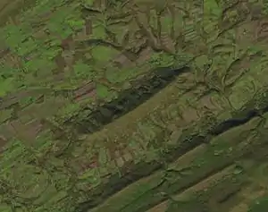
2016 Landsat image of Egg Hill
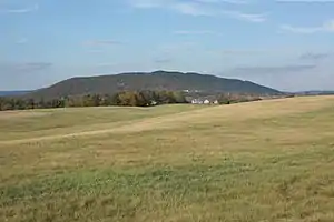
Egg Hill, viewed facing north from Route 322
The historic Egg Hill Church is located at the southwestern end of the hill.
Geology
The crest of Egg Hill is along the axis of a minor syncline, within the larger Nittany Anticlinorium. The bedrock along the axis is the Ordovician Bald Eagle Formation, which is mostly sandstone.[3] The crest of the hill is over 1,900 feet (580 m) elevation.
References
| Wikimedia Commons has media related to Egg Hill, Pennsylvania. |
- U.S. Geological Survey Geographic Names Information System: Egg Hill
- Spring Mills, PA, 7.5' Topographic Quadrangle Map, 2016. USGS. Scale 1:24,000.
- Berg, T.M., Edmunds, W.E., Geyer, A.R. and others, compilers, (1980). Geologic Map of Pennsylvania: Pennsylvania Geologic Survey, Map 1, scale 1:250,000.
This article is issued from Wikipedia. The text is licensed under Creative Commons - Attribution - Sharealike. Additional terms may apply for the media files.