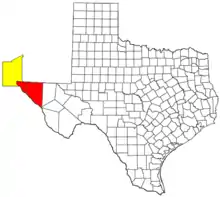
El Paso–Las Cruces, Texas–New Mexico, combined statistical area
The El Paso–Las Cruces, Texas–New Mexico, combined statistical area consists of two counties in western Texas and one in southern New Mexico. This CSA was defined as part of the United States Office of Management and Budget's 2013 delineations for metropolitan, micropolitan, and combined statistical areas.[1] As of the 2018 census estimate, the CSA had a population of 1,063,075 making it the 56th largest combined statistical area in the United States.[2] The statistical area consists of the metropolitan areas of El Paso, Texas and Las Cruces, New Mexico. This CSA has a GDP of about $33 billion and would rank 58th nationally among all CSA or metro areas.[3] The total land area of the El Paso–Las Cruces combined statistical area is 9,402 sq. mi.
Counties

Communities
El Paso County
- Agua Dulce, Texas
- Anthony, Texas (City)
- Butterfield, Texas
- Canutillo, Texas
- Clint, Texas
- Fabens, Texas
- Fort Bliss, Texas
- Homestead Meadows North, Texas
- Homestead Meadows South, Texas
- El Paso, Texas (Principal city)
- Horizon City, Texas (City)
- Montana Vista, Texas
- Morning Glory, Texas
- Newman, Texas
- Prado Verde, Texas
- San Elizario, Texas (City)
- Socorro, Texas (City)
- Tornillo, Texas
- Vinton, Texas
- Westway, Texas
Doña Ana County
- Anthony, New Mexico (City)
- Chamberino, New Mexico
- Chaparral, New Mexico
- Doña Ana, New Mexico
- Hatch, New Mexico
- La Mesa, New Mexico
- Las Cruces, New Mexico (Principal city)
- Mesilla, New Mexico
- Mesquite, New Mexico
- Organ, New Mexico
- Picacho, Dona Ana County, New Mexico
- Radium Springs, New Mexico
- Rincon, New Mexico
- Salem, New Mexico
- Santa Teresa, New Mexico
- Sunland Park, New Mexico (City)
- University Park, New Mexico
- Vado, New Mexico
- White Sands, New Mexico
Hudspeth County
- Allamoore, Texas
- Dell City, Texas
- Salt Flat, Texas
- Sierra Blanca, Texas (Principal City)
References
- Executive Office of the President – Office of Management and Budget – OMB Bulletin No. 13-01 (February 28,2013)
- "Annual Estimates of the Resident Population: April 1, 2010 to July 1, 2018 - United States -- Combined Statistical Area; and for Puerto Rico". United States Census Bureau, Population Division. March 2019. Retrieved October 5, 2019.
- – Bureau of Economic Analysis – U.S. Department of Commerce (February 28, 2013)
- "OMB Bulletin No. 17-01: Revised Delineations of Metropolitan Statistical Areas, Micropolitan Statistical Areas, and Combined Statistical Areas, and Guidance on Uses of the Delineations of These Areas" (PDF). United States Office of Management and Budget. August 15, 2017. Retrieved January 2, 2018.