El Paso Formation
The El Paso Formation is a geologic formation that is exposed from the Permian Basin of New Mexico and Texas to southeastern Arizona. It preserves fossils dating back to the Ordovician period.[1][2][3]
| El Paso Formation Stratigraphic range: Ordovician | |
|---|---|
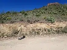 El Paso Formation in road cut near Lake Valley, New Mexico, USA | |
| Type | Formation |
| Sub-units | See text |
| Underlies | Portal Formation, Montoya Group |
| Overlies | Bliss Formation, Coronado Sandstone |
| Thickness | 137–300 meters (449–984 ft) |
| Lithology | |
| Primary | Limestone, dolomite |
| Other | Siltstone |
| Location | |
| Coordinates | 31.90°N 106.49°W |
| Region | Texas, New Mexico, Arizona |
| Country | United States |
| Type section | |
| Named for | El Paso, Texas |
| Named by | G.B. Richardson |
| Year defined | 1904 |
 El Paso Formation (the United States) 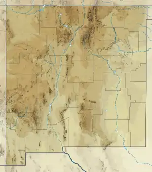 El Paso Formation (New Mexico) | |
Description
The formation is composed of gray cherty dolomite, limestone, and smaller amounts of siltstone.[4] Total thickness is 137–300 meters (449–984 ft).[1][5][4] It lies unconformably on the Bliss Formation[1][5] or the Coronado Sandstone[4] and is overlain by the Montoya Group[2] or Portal Formation.[4]
Fossils
The formation is only sparsely fossiliferous, but contains fossils of echinoderms, gastropods, trilobites, sponge spicules, and Nuia. Rare ostracods, cephalopods, and brachiopods are also found, as is the trace fossil Planolites. Bioherms up to 6 meters (20 ft) high are found in the McKelligon Member, built up of siliceous sponges and receptaculitid Calathium.[6]
History of investigation
The formation was first named by G.B. Richardson in 1904 for exposures in the Franklin and Hueco Mountains. All Ordovician beds of the Franklin Mountains were originally included in the formation.[1] Richardson later (1908) mapped the formation into the Permian Basin and assigned the upper Ordovician beds to the Montoya Limestone.[2] In 1965, Zeller divided the formation in southwestern New Mexico into the Sierrita and Bat Cave Members.[7] Clemons (1991) divided the formation differently, into the Hitt Canyon, Jose, McKelligon, and Padre Members.[8]
In 1964, R.H. Flowers proposed promoting the El Paso Formation to group rank and recommended several divisions into formations, based largely on biostratigraphy, such as the Big Hatchet Formation, the Cooks Formation, the Florida Mountain Formation, the Scenic Drive Formation, or the Victorio Hills Formation.[9] However, this has not been widely accepted,[10][4] and Greg H. Mack rejected both the promotion of the El Paso Formation to group rank and the designation of biostratigraphic zones within the El Paso as formations.[6]
Footnotes
- Richardson 1904
- Richardson 1908
- Gillerman 1958
- Drewes et al. 1995
- Drewes 1991
- Mack 2004
- Zeller 1965
- Clemons 1991
- Flowers 1964
- Hayes 1972
References
- Clemons, R.E. (1991). "Petrography and depositional environments of the Lower Ordovician El Paso Formation". New Mexico Bureau of Mines and Mineral Resources Bulletin. 125.
- Drewes, Harald (1991). "Geologic map of the Big Hatchet Mountains, Hidalgo County, New Mexico". U.S. Geological Survey Miscellaneous Investigations Series. Map I-2144. Retrieved 3 August 2020.
- Drewes, Harald; Du Bray, E.A.; Pallister, J.S. (1995). "Geologic map of the Portal quadrangle and vicinity, Cochise County, Arizona". U.S. Geological Survey Miscellaneous Investigations Series. Map I-2450. Retrieved 3 August 2020.
- Flower, R.H. (1964). "The nautiloid order Ellesmeroceratida (Cephalopoda)". New Mexico Bur. Mines and Mineral Resources Mem. 12.
- Gillerman, Elliot (1958). "Geology of the central Peloncillo Mountains, Hidalgo County, New Mexico, and Cochise County, Arizona". New Mexico Bureau of Mines and Mineral Resources Bulletin. 57.
- Hayes, P.T. (1972). "Stratigraphic nomenclature of Cambrian and Lower Ordovician rocks of easternmost southern Arizona and adjacent westernmost New Mexico". U.S. Geological Survey Bulletin. 1372-B: B1–B21.
- Mack, Greg H. (2004). "The late Cambro-Ordovician Bliss and lower Ordovician El Paso Formations, southwestern New Mexico and west Texas". In Mack, G.H.; Giles, K.A. (eds.). The geology of New Mexico. A geologic history: New Mexico Geological Society Special Volume 11. pp. 95–136. ISBN 9781585460106.
- Richardson, G.B. (1904). "Report of a reconnaissance in Trans-Pecos Texas north of the Texas and Pacific Railway". University of Texas, Mineral Survey Bulletin. 9.
- Richardson, G.B. (1908). "Paleozoic formations in Trans-Pecos Texas". American Journal of Science, 4th series. 25 (49): 474–484.
- Zeller, R.A., Jr. (1965). "Stratigraphy of the Big Hatchet Mountains Area, New Mexico". New Mexico Bureau of Mines and Mineral Resources Memoir. 16.