Eldorado Township, Montgomery County, North Carolina
Eldorado Township, population 1,873,[3] is one of eleven townships in Montgomery County, North Carolina, United States. Eldorado Township is 48.97 square miles (126.8 km2)[1] in size and is located in the northwestern corner of the county.
Eldorado Township, Montgomery County, North Carolina | |
|---|---|
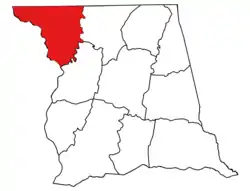 Location of Eldorado Township in Montgomery County | |
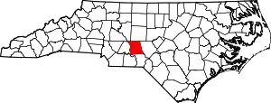 Location of Montgomery County in North Carolina | |
| Country | United States |
| State | North Carolina |
| County | Montgomery |
| Area | |
| • Total | 48.97 sq mi (126.83 km2) |
| Highest elevation [2] (about 1 mile southeast of Blaine, North Carolina) | 946 ft (288 m) |
| Lowest elevation | 275 ft (84 m) |
| Population (2010) | |
| • Total | 1,873[3] |
| • Density | 38.25/sq mi (14.77/km2) |
| Time zone | UTC-4 (EST) |
| • Summer (DST) | UTC-5 (EDT) |
| Area code(s) | 910 |
Geography
Eldorado Township is drained by the Uwharrie River and Yadkin River, which together form the Pee Dee River. Tributaries to the Uwharrie River in Eldorado Township include Gold Mine Branch, Moccasin Creek, Horsepen Creek, and Crow Creek. Tributaries to the Yadkin River include Garr Creek, Reynolds Creek, Alls Fork, Reeves Spring Branch, and Dutch John Creek.[2]
References
- "NC OneMap". www.nconemap.gov. State of North Carolina. Retrieved 13 September 2020.
- "The National Map - Service Endpoints". viewer.nationalmap.gov. US Geological Survey. Retrieved 13 September 2020.
- "US Census Bureau". data.census.gov. US Census Bureau. Retrieved 15 September 2020.
Municipalities and communities of Montgomery County, North Carolina, United States | ||
|---|---|---|
| Towns |  Montgomery County map | |
| Unincorporated communities | ||
| ||
This article is issued from Wikipedia. The text is licensed under Creative Commons - Attribution - Sharealike. Additional terms may apply for the media files.