Eucla Airport
Eucla Airport is an airstrip in Eucla, Western Australia. It has one runway that is 1369 m long. It has a Traffic Pattern Altitude of 305 m.[1] It is mostly used by the Royal Flying Doctor Service of Australia, who completed 84 medical evacuations from the airstrip between 2009 and 2014. There is an ongoing campaign to upgrade the flood-prone airstrip. When it is unusable, aircraft must land on the nearby Eyre Highway.[2]
Eucla Airport | |||||||||||
|---|---|---|---|---|---|---|---|---|---|---|---|
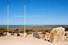 Eucla War Memorial, with the Airport runways and the Great Australian Bight behind it | |||||||||||
| Summary | |||||||||||
| Airport type | Public | ||||||||||
| Location | Eucla, Western Australia | ||||||||||
| Coordinates | 31°42′26″S 128°52′29″E | ||||||||||
| Map | |||||||||||
 YECL Location in Western Australia | |||||||||||
| Runways | |||||||||||
| |||||||||||
Sources: Airport Guide[1] | |||||||||||
References
- "Eucla Airport – YECL". Airport Guide. Retrieved 30 March 2017.
- Lucas, Jarrod (6 December 2016). "Airstrip upgrade urgently required say residents of remote Nullarbor town". ABC News. Retrieved 30 March 2017.
This article is issued from Wikipedia. The text is licensed under Creative Commons - Attribution - Sharealike. Additional terms may apply for the media files.