Expo/Crenshaw station
Expo/Crenshaw is a light rail station in the Los Angeles County Metro Rail system located in the Jefferson Park neighborhood of Los Angeles at the intersection of Crenshaw and Exposition Boulevards. The station currently consists of at-grade platforms served by the E Line; new subway platforms, to be served by the Crenshaw/LAX Line, are under construction.[1][2]
Expo/Crenshaw | ||||||||||||||||||||||||||||||||||||
|---|---|---|---|---|---|---|---|---|---|---|---|---|---|---|---|---|---|---|---|---|---|---|---|---|---|---|---|---|---|---|---|---|---|---|---|---|
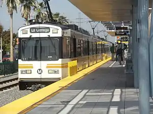 Metro Expo Line heading westbound to Culver City Station leaves Expo/Crenshaw Station. | ||||||||||||||||||||||||||||||||||||
| Location | 3428 Exposition Boulevard, Los Angeles, California | |||||||||||||||||||||||||||||||||||
| Coordinates | 34.0225°N 118.3350°W | |||||||||||||||||||||||||||||||||||
| Owned by | Metro | |||||||||||||||||||||||||||||||||||
| Platforms | 2 nearside platforms (E Line) 1 center platform (Crenshaw/LAX Line) | |||||||||||||||||||||||||||||||||||
| Tracks | 2 | |||||||||||||||||||||||||||||||||||
| Connections | Metro Local: 209, 210 | |||||||||||||||||||||||||||||||||||
| Construction | ||||||||||||||||||||||||||||||||||||
| Parking | 450 nearby free spaces (independent) Monday-Saturday, excluding Sunday | |||||||||||||||||||||||||||||||||||
| Bicycle facilities | 10 bike racks | |||||||||||||||||||||||||||||||||||
| Disabled access | Yes | |||||||||||||||||||||||||||||||||||
| Other information | ||||||||||||||||||||||||||||||||||||
| Status | in service | |||||||||||||||||||||||||||||||||||
| History | ||||||||||||||||||||||||||||||||||||
| Opened | October 17, 1875 | |||||||||||||||||||||||||||||||||||
| Rebuilt | April 28, 2012 | |||||||||||||||||||||||||||||||||||
| Previous names | 11th Ave | |||||||||||||||||||||||||||||||||||
| Services | ||||||||||||||||||||||||||||||||||||
| ||||||||||||||||||||||||||||||||||||
| Location | ||||||||||||||||||||||||||||||||||||

| ||||||||||||||||||||||||||||||||||||
Service
Metro Rail service
E Line service hours are approximately from 4:00 AM until 12:30 AM daily. Metro Rail service at the station opened on Saturday, April 28, 2012. Regular scheduled service began on Monday, April 30, 2012.
Location and design
The E Line platforms are located in the median strip of Exposition Boulevard on either side of its intersection with the busy Crenshaw Boulevard, a major L.A. thoroughfare. This intersection is a short walk to either Obama Boulevard [3] or Jefferson Blvd. The entrance to the subway station currently being built as part of the Crenshaw/LAX Line project will be located at the southeast corner of Expo and Crenshaw.
The station is within walking distance to the following:
- West Angeles Cathedral
- Crenshaw Crossing outdoor multi-level retail center (planned)[4]
- Crenshaw Gardens [5]
- OneUnited Bank office building
- Infamous Black Dahlia body site
Station layout
The station has "near-side" platforms: this means that the platforms are positioned on opposite sides of the intersection, and trains always stop at the platform before crossing the intersection.
| G | Side platform, doors will open on the right | |
| Platform 2 (Westbound) | ← | |
| Platform 1 (Eastbound) | → | |
| Side platform, doors will open on the right | ||
| Ticket machines | ||
| B1 | Faregates, Ticket machines | |
| B2 | Platform 4 (Southbound) | ← |
| Island platform, doors will open on the left or right | ||
| Platform 3 (Southbound) | ||
Art
The station incorporates artwork by three artists: Erwin Redl, Rebeca Méndez, and Jaime Scholnick.[6] The station's art was created by artist Willie Robert Middlebrook Jr.; his untitled installation uses manipulated photographs to depict the diverse population in interaction with the earth and the environment.[7]
History
Originally a stop on the Los Angeles and Independence and Pacific Electric interurban line, it was closed on September 30, 1953 with closure of the Santa Monica Air Line and remained out of service and eventually dismantled, until re-opening on Saturday, April 28, 2012. It was completely rebuilt for the opening of the Expo Line from little more than a station stop marker. Regular scheduled service resumed Monday, April 30, 2012.
Crenshaw/LAX Line
The station will become a transfer station hub when the Crenshaw/LAX Line service begins in 2021. The Metro staff board ruled out an at-grade junction station between the Crenshaw/LAX Line and E Line, stating that it is operationally not feasible. (Such a junction would result in three rail lines—the Crenshaw, E, and the A Lines—sharing the single pair of tracks on Flower Street leading into 7th Street/Metro Center station, putting those tracks well above their capacity limit and causing delays.) Instead, a light rail subway station for the Crenshaw/LAX Line is being constructed under Crenshaw Boulevard between Exposition Boulevard and Obama Boulevard (formerly Rodeo Road) in order to allow for an extension of the Crenshaw/LAX Line north through a D Line station and to the B Line's Hollywood/Highland station, where it will terminate via a route to be determined.[8][9]
References
- "Expo - Phase 1 - Overview". BuildExpo.org. 2010. Archived from the original on 2013-10-04. Retrieved 2014-01-23.
- "E Line Map" (PDF).
- "LA City Council green lines south la street name change". nbclosangeles.com. Retrieved 2017-06-28.
- "A First Glimpse of the District Square Development". Retrieved 2017-06-03.
- "Crenshaw Gardens". www.urbanize LA.com. Retrieved 2017-06-03.
- Broverman, Neal (January 22, 2018). "An Early Look at All the Artwork Coming to the Metro Crenshaw Line Los Angeles Magazine". Los Angeles Magazine. Retrieved April 21, 2019.
- "Expo - Expo Art Program". BuildExpo.org. 2010. Archived from the original on 2013-10-04. Retrieved 2014-01-23.
- "Crenshaw Transit Corridor Project Final Feasibility Study - Wilshire/La Brea Transit Extension" (pdf). Metro (LACMTA). May 2009. Retrieved 2014-01-23.
- "Feasibility study looks at possible routes for Crenshaw Northern". The Source. July 2018. Retrieved 2018-08-16.
External links
| Wikimedia Commons has media related to Expo / Crenshaw (Los Angeles Metro station). |
- Metro Expo Line Construction Authority
- Project Website, Metro Rail Expo Corridor, Phase 1 to Culver City