Feather Canyon
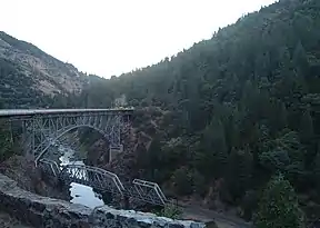
The Feather Canyon (or Feather River Canyon) is a 42 mi (68 km) landform in the Feather Headwaters between Pulga, California (west) and Keddie, California (east) along portions of the North Fork Feather River (west & downstream) and the East Branch North Fork Feather River (east & upstream). The canyon is the location of portions of California State Route 70 and the Feather River Route, including the Tobin Bridges.[2]
| Feather Canyon | |
|---|---|
 | |
| Geography | |
| Location | California, United States |
| Population centers | Pulga, Keddie |
| Traversed by | California State Route 70, Feather River Route |
The Feather River Canyon is well-known for high winds. The "Jarbo Winds", named for nearby Jarbo Gap, often blow down the canyon from the northeast. These katabatic winds are caused by high-pressure air over the Great Basin seeking a path through the Sierra Nevada to the low-pressure voids on the California coast. The 2018 Camp Fire, the deadliest wildfire in California's history, was driven into Paradise by these winds. [3] Meteorological records show 36 days since 2003 with gusts of 100 mph or more, up to 200 mph.
References
- Gascoyne, Tom (July 12, 2001). "Empty Promise". Retrieved 2010-12-01.
A 12-car train took the guests up the Feather River Canyon to where the dam was to sit. There Gov. Goodwin Knight gave a short speech hailing the historic importance of what was to transpire on that very ground
- Oxlade, John (31 December 2003). "Out-n-About - The Feather River Canyon,[sic) California, USA". WorldRailFans.info. Archived from the original on 28 July 2011. Retrieved 2010-09-11.
the actual "canyon" portion petween Pulga and Keddie is only approx. 42 miles
- Here's how Paradise ignored warnings and became a deathtrap, LA Times, Dec 30, 2018