Fictional geography
Fictional geography is the use of maps, text and imagery to create lands and territories to accompany works of fiction. Depending on the completeness and complexity of the work, varying media, levels of collaboration and a number of other factors, the depiction of geographical components to works of fiction can range from simple drawings of a small area as in The Twenty-One Balloons by William Pène du Bois to an entire fictional world as in The Lord of the Rings by Tolkien or even an entire galaxy as in Star Trek and its variants.
Examples
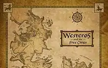
A map of Westeros, a continent of the fictional World of A Song of Ice and Fire, by George R. R. Martin.
| Name | Author(s) | Publishing Date |
|---|---|---|
| Middle-earth | J. R. R. Tolkien and Christopher Tolkien | 1965 |
| Narnia | C. S. Lewis | 1950 |
| Earthsea | Ursula K. Le Guin | 1968 |
| Tamriel | Bethesda Softworks | 1994 |
| World of A Song of Ice and Fire | George R. R. Martin | 1996 |
See also
- List of fictional location types
This article is issued from Wikipedia. The text is licensed under Creative Commons - Attribution - Sharealike. Additional terms may apply for the media files.