Finnmarksvidda
Finnmarksvidda (Northern Sami: Finnmárkkoduottar; English: Finnmark plateau/highland) is Norway's largest plateau, with an area greater than 22,000 square kilometres (8,500 sq mi).[1] The plateau lies about 300 to 500 metres (980 to 1,640 ft) above sea level. Approximately 36% of Finnmark lies on the Finnmarksvidda.
| Finnmarksvidda | |
|---|---|
| Finnmárkkoduottar (Northern Sami) | |
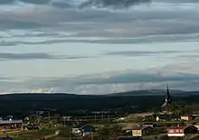
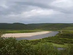 The lowest elevations can be found in the eastern part of Finnmarksvidda, near Karasjok and Tana. River valleys in the area are only 100 - 250 m above sea level. | |
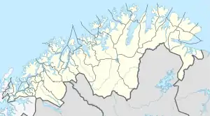 Finnmarksvidda Location of the plateau  Finnmarksvidda Finnmarksvidda (Norway) | |
| Location | Troms og Finnmark, Norway |
| Coordinates | 69°19′N 23°49′E |
| Elevation | 300 to 500 m (980 to 1,640 ft) |
| Area | 22,000 km2 (8,500 sq mi) |
Geography
From Alta Municipality in the west to the Varanger Peninsula in the east it stretches for approximately 300 kilometres (190 mi), being at least that wide from north to south, extending into Finland. The southeastern part of the plateau is protected by the Øvre Anárjohka National Park. The 1,409 square kilometres (544 sq mi) park opened in 1976.[2]
Fauna and flora
The plateau includes extensive birch woods, pine barrens, bogs, and glacially formed lakes. Finnmarksvidda is situated north of the Arctic Circle and is best known as the land of the once nomadic Sami people and their reindeer herds. Their shelters in the tundra, are still in use in winter time.
Climate
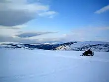
Finnmarksvidda, located in the interior of the county has a continental climate with the coldest winter temperatures in Norway: the coldest temperature ever recorded was −51.4 °C (−60.5 °F) in Karasjok on 1 January 1886. The 24-hour averages for January and July in the same location are −17.1 °C (1.2 °F) and 13.1 °C (55.6 °F), while the yearly average is merely −2.4 °C (27.7 °F). Precipitation is only 366 millimetres (14.4 in) per year.[3] Karasjok has recorded up to 32.4 °C (90.3 °F) in July, giving a possible yearly amplitude of 84 °C (151 °F), which is rare in Europe. The annual mean temperatures on the plateau are as low as −3 °C (27 °F) (Sihcajavri in Kautokeino), this being is the lowest average in mainland Norway (apart from the mountaintops) − lower even than that of Jan Mayen and Bjørnøya.
References
- "About Finnmark". Turistforeningen.
- Ryvarden, Leif (2007). Stabbursdalen, Øvre Pasvik og Øvre Anárjohka. Norges nasjonalparker (in Norwegian). 3. Gyldendal. ISBN 9788205376380.
- "Normaler for kommune 2021" (in Norwegian). The Norwegian Meteorological Institute. Archived from the original on 2007-11-20.
| Authority control |
|
|---|