Flat Rock Dam (Pennsylvania)
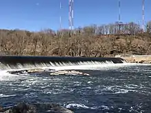
The Flat Rock Dam is an earthen dam across the Schuylkill River. The river flows through the dam at a rate of about 2540 CFS.[1] A future hydroelectric project plans to place turbines to generate 1.5 MW of electricity.[2]
| Flat Rock Dam | |
|---|---|
 | |
| Official name | Flat Rock Dam |
| Location | Philadelphia-Montgomery counties, Pennsylvania, USA 40°02′23″N 75°14′49″W |
| Opening date | 1970s |
| Dam and spillways | |
| Impounds | Schuylkill River |
The dam is part of the Flat Rock Park maintained by Lower Merion Township, Montgomery County, Pennsylvania and is located off the Schuylkill Expressway in Gladwyne.[3]
The dam is part of a series of locks and waterway built by Schuylkill Navigation Company between Port Carbon and Philadelphia, in order to carry upstate coal to markets in the city. It creates a pool for the canal boats above it, and it brings water to the Manayunk Reach. Under the supervision of Ariel Cooley, a Massachusetts engineer who was responsible for the design of the Fairmount Dam, the construction of the dam and locks started on 1815, until its completion in 1818.[4]
References
- "Schuylkill:Flat Rock Dam".
- "Flat Rock Dam Hydro".
- "Flat Rock Park Improvements".
- "Flat Rock Dam – Built For Transporting Coal in 1818 - Was A Popular Recreation Site - And A Backdrop to Tragedies and Heroic Rescues". This Is Lower Merion And Narberth. 2020-06-14. Retrieved 2020-07-22.
See also


- List of crossings of the Schuylkill River