Floodway (road)
A floodway is a flood plain crossing for a road, built at or close to the natural ground level.[1] It is similar to a causeway, but crosses a shallow depression that is subject to flooding, rather than a waterway or tidal water.[2]
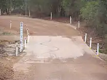
A floodway on a gravel road
They are designed to be submerged under water, but withstand such conditions. Typically floodways are used when the flood frequency or time span is minimal, traffic volumes are low, and the cost of a bridge is uneconomic[2][3] – in most cases, in rural areas.
.jpg.webp)
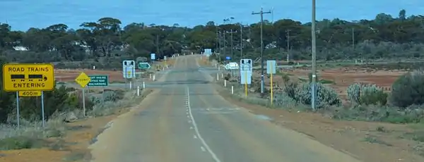
Floodway on Great Northern Highway, Western Australia
Floodway and signs, eastern side of Southern Cross, Western Australia
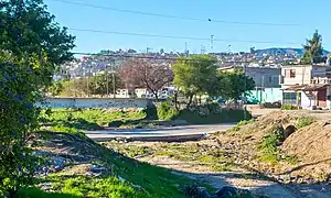
Floodway (road goes across the photo) in Baja California, Mexico. Note bridge behind it.
Notes
- Edmonds, Leigh (1997). The Vital Link: A History of Main Roads Western Australia 1926–1996. Nedlands, Western Australia: University of Western Australia Press. p. 184. ISBN 1-875560-87-4.
- MRWA Waterways Section; BG&E Pty Ltd (24 April 2006). "Floodway Design Guide" (PDF). Main Roads Western Australia. p. 4. Archived from the original (PDF) on 15 April 2015. Retrieved 15 April 2015. Additional archives: 15 April 2015.
- Austroads; Flavell, David; Audora, Henry (1994), Waterway design : a guide to the hydraulic design of bridges, culverts and floodways, Austroads, ISBN 978-0-85588-440-6
- Department of Transport and Main Roads (March 2010). "Chapter 10 Floodway Design" (PDF). Road Drainage Manual. Queensland Government.
- Lokuge, Weena; Setunge, Sujeeva; Karunasena, Warna (2014). Investigating the performance of floodway in an extreme flood event (PDF). 1st International Conference on Infrastructure Failures and Consequences (ICFC 2014) 16–20 July 2014. Melbourne, Australia.
- Greene, I.; Lokuge, W.; Karunasena f, W. (2020). Floodway Design Process Revisted (PDF). 25th Australasian Conference on Mechanics of Structures and Materials (ACMSM25), 4–7 December 2018. Brisbane, Australia – via University of Southern Queensland.
External links
This article is issued from Wikipedia. The text is licensed under Creative Commons - Attribution - Sharealike. Additional terms may apply for the media files.