Florida State Road 421
State Road 421 (SR 421) is a major thoroughfare that runs east–west through Port Orange, Florida from Interstate 95 (I-95) east to U.S. Route 1 (US 1) where it turns into SR A1A. It is partially six lanes (from I-95 east to SR 5A) and 4 lanes (from SR 5A east to US 1), and is known locally as Taylor Road (for about 1⁄2 mile (0.80 km) east of I-95) and Dunlawton Avenue.
| ||||
|---|---|---|---|---|
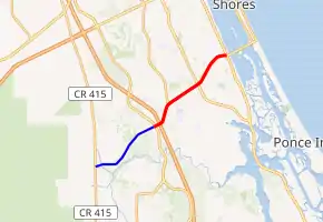
SR 421 in red, CR 421 in blue | ||||
| Route information | ||||
| Length | 4.001 mi[1] (6.439 km) | |||
| Major junctions | ||||
| West end | ||||
| East end | ||||
| Location | ||||
| Counties | Volusia | |||
| Highway system | ||||
| ||||


Taylor Road continues west as County Road 421 (CR 421) to CR 415 (Tomoka Farms Road).[2]
Major intersections
The entire route is in Port Orange, Volusia County.
| mi[1] | km | Destinations | Notes | ||
|---|---|---|---|---|---|
| 0.000 | 0.000 | West end of state maintenance | |||
| 0.055 | 0.089 | ||||
| 0.128– 0.338 | 0.206– 0.544 | I-95 exit 256 | |||
| 1.068 | 1.719 | ||||
| 2.382 | 3.833 | ||||
| 4.001 | 6.439 | ||||
| 1.000 mi = 1.609 km; 1.000 km = 0.621 mi | |||||
References
- Transportation and Data Analytics Office (December 10, 2018). "Straight Line Diagram of Road Inventory". Florida Department of Transportation. Retrieved May 1, 2020.
- FDOT Map of Volusia County
External links
This article is issued from Wikipedia. The text is licensed under Creative Commons - Attribution - Sharealike. Additional terms may apply for the media files.