Florida State Road 482
State Road 482 (SR 482), named Sand Lake Road and McCoy Road, is an east–west state highway in south Orlando, Florida, United States. It is a surface road providing access to some of Orlando's biggest tourist attractions.
| ||||
|---|---|---|---|---|
| ||||
| Route information | ||||
| Maintained by FDOT | ||||
| Length | 7.813 mi[1] (12.574 km) | |||
| Major junctions | ||||
| West end | ||||
| East end | ||||
| Location | ||||
| Counties | Orange | |||
| Highway system | ||||
| ||||

Route description
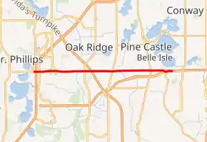
Sand Lake Road begins at Apopka-Vineland Road in Dr. Phillips. State maintenance as SR 482 begins between Turkey Lake Road and Interstate 4 (SR 400). SR 482 heads east past the International Drive area to a partial cloverleaf interchange with State Road 435 (Kirkman Road) just north of the entrance to Lockheed Martin. East of that, SR 482 continues towards an intersection with County Road 423 (John Young Parkway), crossing under Florida's Turnpike, and intersects US 17/US 92/US 441 (Orange Blossom Trail) just west of The Florida Mall. It continues east, changing names from Sand Lake Road to McCoy Road at State Road 527 (Orange Avenue). SR 482 ends at the interchange with State Road 528 (Beachline Expressway) and Boggy Creek Road west of Orlando International Airport; McCoy Road continues as the north-side frontage road to SR 528, cut in several places, to State Road 15 (Narcoossee Road).
Attractions
On this road features the world's largest McDonald's, as well as the Skyplex complex located at the corner of that street and International Drive in the future.
History
It was part of State Road 528 and then State Road 528A before being renumbered SR 482.
Major intersections
The entire route is in Orange County.
| Location | mi[1] | km | Destinations | Notes | |
|---|---|---|---|---|---|
| Doctor Phillips | 0.000– 0.186 | 0.000– 0.299 | Exit 74A on I-4 (SR 400); continues west without designation | ||
| Orlando | 0.351 | 0.565 | International Drive | ||
| 1.100 | 1.770 | Interchange; southern terminus of SR 435 | |||
| 2.981 | 4.797 | Interchange | |||
| Sky Lake | 4.618 | 7.432 | Road is unsigned SR 500 / SR 600 | ||
| Belle Isle | 6.874 | 11.063 | Termini of SR 527 and CR 527A | ||
| 7.813 | 12.574 | Tolled highway; exit 8 on SR 528 (Beachline Expressway); northern terminus of CR 530 | |||
1.000 mi = 1.609 km; 1.000 km = 0.621 mi
| |||||
References
- Transportation and Data Analytics Office (December 12, 2012). "Straight Line Diagram of Road Inventory". Florida Department of Transportation. Retrieved April 17, 2020.
External links
 Media related to Florida State Road 482 at Wikimedia Commons