Franck Nunataks
The Franck Nunataks (71°32′S 72°23′W) are a scattered group of small rock outcrops, 3 nautical miles (6 km) in extent, at the base of the Beethoven Peninsula in the southwest part of Alexander Island, Antarctica. They were first mapped from air photos taken by the Ronne Antarctic Research Expedition, 1947–48, by D. Searle of the Falkland Islands Dependencies Survey in 1960. They were named by the UK Antarctic Place-Names Committee after César Franck, the French composer,[1] 1822–1890.
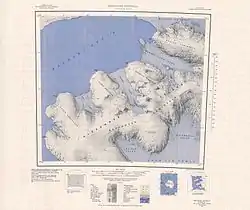
Topographic reconnaissance map of the Beethoven Peninsula area of Alexander Island from in Antarctica including Franck Nunataks
References
- "Franck Nunataks". Geographic Names Information System. United States Geological Survey. Retrieved 2012-04-06.
![]() This article incorporates public domain material from the United States Geological Survey document: "Franck Nunataks". (content from the Geographic Names Information System)
This article incorporates public domain material from the United States Geological Survey document: "Franck Nunataks". (content from the Geographic Names Information System)
This article is issued from Wikipedia. The text is licensed under Creative Commons - Attribution - Sharealike. Additional terms may apply for the media files.