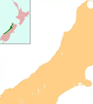
Franz Josef / Waiau
Franz Josef / Waiau is a small town in the West Coast region of the South Island of New Zealand. Whataroa is 32 kilometres (20 mi) to the north-east, and the township of Fox Glacier is 23 kilometres (14 mi) to the south-west. State Highway 6 runs through the town. The Waiho River runs from the Franz Josef Glacier to the south, through the town, and into the Tasman Sea to the north-west.[1][2]
Franz Josef / Waiau | |
|---|---|
Village | |
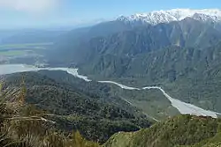 Franz Josef (middle left), next to the Waiho River, as seen from Alex Knob | |
 Franz Josef / Waiau | |
| Coordinates: 43°23′17″S 170°10′55″E | |
| Country | New Zealand |
| Region | West Coast |
| District | Westland District |
| Electorates | West Coast-Tasman Te Tai Tonga |
| Area | |
| • Total | 5.31 km2 (2.05 sq mi) |
| Population (2018 census) | |
| • Total | 483 |
| • Density | 91/km2 (240/sq mi) |
| Time zone | UTC+12 (NZST) |
| • Summer (DST) | UTC+13 (NZDT) |
| Postcode | 7886 |
| Area code(s) | 03 |
| Local iwi | Ngāi Tahu |
.jpg.webp)
Established about 1911 by the Graham brothers and run by them it was sold to the New Zealand Government in 1947
Name
The town is named after the Franz Josef Glacier – itself named by Julius von Haast in honour of the Emperor of Austria Franz Josef I of Austria. Following the passage of the Ngāi Tahu Claims Settlement Act 1998, the name of the town was officially altered to Franz Josef / Waiau.[3]
Geography
Flood protection
The bed of the Waiho (Waiau) River has significantly risen over the years, and increased rainfall and snow melt from the retreating glacier has caused the river's water flow to vary greatly. The riverbed is currently predicted to rise 2 m every 10 years, and in 30 years will be higher than the town itself.[4][5] A flood in February 2016 caused $30 million of damage.[5] In a severe rain storm on 26 March 2019, 400 millimetres (16 in) of rain fell and the bridge over the Waiho, the only road connection to south Westland, was destroyed.[6] The town was flooded and hundreds were evacuated. The bridge and one abutment was rebuilt and the road link reopened after 18 days at a cost of NZ$6m.[7]
Flood protection was deemed a priority for the township of Franz Josef, and a $24m package was approved by the Government in July 2020, as part of the COVID-19 economic stimulus package.[8] The work included $18m for rock embankments on the north and south banks, and $3.8m to raise the level of the highway bridge. The work had not begun as of January 2021, leading to criticism from National MP Maureen Pugh and Regional Council head Allan Birchfield.[8][9] MP Damien O'Connor said "piling more rocks around the river" was not a long-term solution.[10]
One proposal made in a 2017 report was to remove embankments on the river's southern bank, allowing it to widen and flood several thousand hectares of farmland. This would affect 82 people and 40 properties, who would need compensation by central government.[5]
Another proposal for the future of Franz Josef is to relocate the entire town away from the flood danger and the alpine fault to the shore of Lake Mapourika, 10 km north of the town.[4][5] The estimated cost for this is $300–$600 million, or as high as $1 billion.[11][12][5]
Demographics
Franz Josef is defined by Statistics New Zealand as a rural settlement and covers 5.31 km2 (2.05 sq mi). It is part of the wider Westland Glaciers-Bruce Bay statistical area.[13]
The Franz Josef settlement had a usual resident population of 483 at the 2018 New Zealand census, an increase of 156 people (47.7%) since the 2013 census, and an increase of 177 people (57.8%) since the 2006 census. There were 243 males and 237 females, giving a sex ratio of 1.03 males per female. Of the total population, 48 people (9.9%) were aged under 15, 219 people (45.3%) were 15 to 29, 210 people were 30 to 64 (43.4%), and six people (1.2%) were 65 or over.[14]
In terms of ethnicity, 60.2% of residents were European, 7.5% were Māori, 6.8% were Pacific peoples, 23.6% were Asian, and 6.2% were other ethnicities (totals add to more than 100% since people could identify with multiple ethnicities).[14]
Although Franz Josef has only 330 local ratepayers, it regularly received 600,000 tourist visitors a year until the COVID-19 epidemic restricted travel to New Zealand.[5]
Tourism
The glacier's terminal face is 5 kilometres (3 mi) from the town and its accessibility makes it a major tourist attraction and the reason many people visit Franz Josef. The town is within the Westland Tai Poutini National Park.
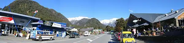
Franz Josef offers many accommodation options for the up to 2,000 people staying overnight during the main season, ranging from hotels and motels to holiday houses, camping sites and backpacker accommodation. Other amenities include a petrol station, small but busy heliport and a number of restaurants and shops.[15] The village is connected to the Franz Josef Glacier valley via walking tracks and a small sealed road leading into the valley from the highway just south of the village.
Franz Josef village is also home to the West Coast Wildlife Centre, a public/private partnership with the Department of Conservation and local iwi, dedicated to the hatching and incubation of the world's two rarest species of kiwi, the rowi and Haast tokoeka. The centre is open from 8.30am daily and offers a 24-hour general pass as well as VIP guided backstage pass tours for behind-the-scenes tours of its kiwi hatching and rearing facilities.[16]
Churches
St James Church
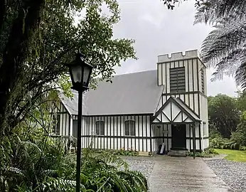
St James Church is a small Anglican church in a bush setting overlooking the Waiho River to the south of Franz Josef township, within the Ross and South Westland Parish.[17] Opened in 1931, the church is notable for its use of clear glass windows behind the altar giving views of the river, mountains and bush beyond. At times during the church's history, Franz Josef Glacier has been visible through the altar window. St James Church was designated as a category 1 historic place by Heritage New Zealand in 1990.[18]
Our Lady of the Alps
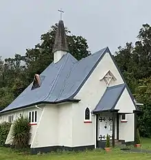
Our Lady of the Alps is a small Catholic church next to State Highway 6 on the southern fringe of Franz Josef, within the South Westland parish of Our Lady of the Woods.[19] The church was dedicated, blessed and opened on 23 December 1951. It is similar in style to Swiss mountain churches with a steeply pitched roof to shed snow, and has prominent buttresses. The porch includes two St Bernard stained-glass windows, one depicting a coil of rope with an ice pick and ski pole crossed, and the other crossed skis and a shield with a flask of brandy and a loaf of bread.[20]
Mass is held at Our Lady of the Alps weekly, on the first and third Sundays and second fourth and fifth Saturdays of each month.[19]
Education
Franz Josef Glacier School is a coeducational full primary (year 1–8) school with a roll of 53 students as of March 2020.[21] The nearest secondary school is South Westland Area School, 62 km (39 mi) away in Hari Hari.
References
- Peter Dowling (editor) (2004). Reed New Zealand Atlas. Reed Books. map 74. ISBN 0-7900-0952-8.CS1 maint: extra text: authors list (link)
- Roger Smith, GeographX (2005). The Geographic Atlas of New Zealand. Robbie Burton. map 173. ISBN 1-877333-20-4.
- "Ngāi Tahu Claims Settlement Act 1998". Retrieved 28 March 2016.
- Benoit, Lisa (10 October 2017). "Move could be reality for Franz Josef town". Newstalk ZB.
- Macmanus, Joel (10 May 2019). "Provincial Growth Fund rejects Franz Josef township move". Stuff. Retrieved 29 January 2021.
- Gorman, Paul; Guildford, Jonathan; Kitchin, Tom (26 March 2019). "State of emergency on West Coast as heavy rain batters region, wipes out bridge". Stuff. Retrieved 26 March 2019.
- Guildford, Jonathan (2 May 2019). "West Coast's Waiho River bridge to close at night as final construction begins". The Press. p. 3. Retrieved 3 May 2019.
- Williams, Lois (13 January 2020). "Govt action urged at 'gloomy' glaciers". Hokitika Guardian. p. 3.
- Murdoch, Helen (14 January 2021). "MP seeks answers on funding delay". Hokitika Guardian. p. 3.
- Williams, Lois (25 January 2021). "Pugh questions Franz delays". Hokitika Guardian. p. 3.
- Mitchell, Charlie (26 October 2017). "Moving Franz Josef township from fault line would cost $300m". Stuff.
- McMahon, Brendon (26 October 2017). "Report finds cost to move Franz Josef township close to $600m". New Zealand Herald.
- "ArcGIS Web Application". statsnz.maps.arcgis.com. Retrieved 15 January 2021.
- "Age and sex by ethnic group (grouped total response), for census usually resident population counts, 2006, 2013, and 2018 Censuses (urban rural areas)". nzdotstat.stats.govt.nz. Retrieved 7 October 2020.
- "Franz Josef Glacier Village". Tourism New Zealand. Retrieved 19 March 2015.
- Anna Turner (20 July 2012). "Influx of kiwi eggs forces centre expansion". The Press. Retrieved 19 March 2015.
- "St James – Waiho Gorge – Ross and South Westland Parish". Anglican Life. Retrieved 23 October 2020.
- Lovell-Smith, Melanie (2 June 2003). "St James Church (Anglican)". Heritage New Zealand. Retrieved 23 October 2020.
- "South Westland – Our Lady of the Woods Parish – Our Lady of the Alps (Franz Josef)". Catholic Diocese of Christchurch. Retrieved 23 October 2020.
- Donovan, Don (2002). Country Churches of New Zealand. Auckland: New Holland. p. 121. ISBN 1869660153.
- "New Zealand Schools Directory". New Zealand Ministry of Education. Retrieved 26 April 2020.
External links
| Wikimedia Commons has media related to Franz Josef, New Zealand. |
 Franz Josef travel guide from Wikivoyage