Galateo, Toa Alta, Puerto Rico
Galateo is a barrio in the municipality of Toa Alta, Puerto Rico. Its population in 2010 was 5,917.[3][4][5]
| Historical population | |||
|---|---|---|---|
| Census | Pop. | %± | |
| 1900 | 606 | — | |
| 1910 | 950 | 56.8% | |
| 1920 | 1,035 | 8.9% | |
| 1930 | 1,249 | 20.7% | |
| 1940 | 1,488 | 19.1% | |
| 1950 | 1,484 | −0.3% | |
| 1980 | 3,745 | — | |
| 1990 | 4,262 | 13.8% | |
| 2000 | 5,296 | 24.3% | |
| 2010 | 5,917 | 11.7% | |
| U.S. Decennial Census[6] 1899 (shown as 1900)[7] 1910-1930[8] 1930-1950[9] 1980-2000[10] 2010[11] | |||
Galateo | |
|---|---|
Barrio | |
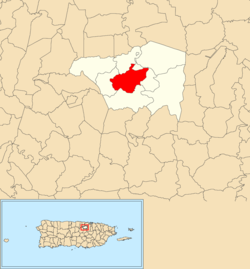 Location of Galateo within the municipality of Toa Alta shown in red | |
 Galateo Location of Puerto Rico | |
| Coordinates: 18°21′39″N 66°15′05″W[1] | |
| Commonwealth | |
| Municipality | |
| Area | |
| • Total | 2.81 sq mi (7.3 km2) |
| • Land | 2.79 sq mi (7.2 km2) |
| • Water | 0.02 sq mi (0.05 km2) |
| Elevation | 66 ft (20 m) |
| Population (2010) | |
| • Total | 5,917 |
| • Density | 2,120.8/sq mi (818.8/km2) |
| Source: 2010 Census | |
| Time zone | UTC−4 (AST) |
History
Puerto Rico was ceded by Spain in the aftermath of the Spanish–American War under the terms of the Treaty of Paris of 1898 and became a territory of the United States. In 1899, the United States conducted its first census of Puerto Rico finding that the population of Galateo barrio was 606.[12]
Sectors
Barrios (which are like minor civil divisions)[13] in turn are further subdivided into smaller local populated place areas/units called sectores (sectors in English). The types of sectores may vary, from normally sector to urbanización to reparto to barriada to residencial, among others.[14][15][16]
The following sectors are in Galateo barrio:[17]
Carretera 824, Parcelas Galateo, Reparto Las Colinas, Reparto Los Chalets, Reparto Luis, Sector Antonio de Gracia, Sector Calderón, Sector Eugenio “Geno” Cosme López, Sector Galateo Centro, Sector Gutiérrez, Sector López, Sector Loubriel, Sector Morales, Sector Ríos, Sector Rivera, Sector Rosado, Sector Vélez, Sector Villa Josco, Urbanización Brisas del Plata, Urbanización Díaz, Urbanización Green Valley, Urbanización Haciendas del Toa, Urbanización Negrón, Urbanización Piedra Linda, Urbanización Quintas de José Alberto, Urbanización Quintas Negrón, Urbanización Veredas del Río I, and Urbanización Veredas del Río II.
References
- "US Gazetteer 2019". US Census. US Government.
- U.S. Geological Survey Geographic Names Information System: Galateo barrio
- Picó, Rafael; Buitrago de Santiago, Zayda; Berrios, Hector H. Nueva geografía de Puerto Rico: física, económica, y social, por Rafael Picó. Con la colaboración de Zayda Buitrago de Santiago y Héctor H. Berrios. San Juan Editorial Universitaria, Universidad de Puerto Rico,1969.
- Gwillim Law (20 May 2015). Administrative Subdivisions of Countries: A Comprehensive World Reference, 1900 through 1998. McFarland. p. 300. ISBN 978-1-4766-0447-3. Retrieved 25 December 2018.
- Puerto Rico:2010:population and housing unit counts.pdf (PDF). U.S. Dept. of Commerce, Economics and Statistics Administration, U.S. Census Bureau. 2010.
- "U.S. Decennial Census". United States Census Bureau. Archived from the original on February 13, 2020. Retrieved September 21, 2017.
- "Report of the Census of Porto Rico 1899". War Department Office Director Census of Porto Rico. Archived from the original on July 16, 2017. Retrieved September 21, 2017.
- "Table 3-Population of Municipalities: 1930 1920 and 1910" (PDF). United States Census Bureau. Archived (PDF) from the original on August 17, 2017. Retrieved September 21, 2017.
- "Table 4-Area and Population of Municipalities Urban and Rural: 1930 to 1950" (PDF). United States Census Bureau. Archived (PDF) from the original on August 30, 2015. Retrieved September 21, 2014.
- "Table 2 Population and Housing Units: 1960 to 2000" (PDF). United States Census Bureau. Archived (PDF) from the original on July 24, 2017. Retrieved September 21, 2017.
- Puerto Rico:2010:population and housing unit counts.pdf (PDF). U.S. Dept. of Commerce Economics and Statistics Administration U.S. Census Bureau. 2010. Archived (PDF) from the original on 2017-02-20. Retrieved 2019-08-02.
- Joseph Prentiss Sanger; Henry Gannett; Walter Francis Willcox (1900). Informe sobre el censo de Puerto Rico, 1899, United States. War Dept. Porto Rico Census Office (in Spanish). Imprenta del gobierno. p. 162.
- "US Census Barrio-Pueblo definition". factfinder.com. US Census. Archived from the original on 13 May 2017. Retrieved 5 January 2019.
- "Agencia: Oficina del Coordinador General para el Financiamiento Socioeconómico y la Autogestión (Proposed 2016 Budget)". Puerto Rico Budgets (in Spanish). Retrieved 28 June 2019.
- Rivera Quintero, Marcia (2014), El vuelo de la esperanza: Proyecto de las Comunidades Especiales Puerto Rico, 1997-2004 (first ed.), San Juan, Puerto Rico Fundación Sila M. Calderón, ISBN 978-0-9820806-1-0
- "Leyes del 2001". Lex Juris Puerto Rico (in Spanish). Retrieved 24 June 2020.
- "PRECINTO ELECTORAL TOA ALTA 013" (PDF). Comisión Estatal de Elecciones (in Spanish). PR Government. 28 October 2019. Retrieved 26 June 2020.