Gardiner Ridge
Gardiner Ridge is a ridge extending from Mount Kauffman to Mount Kosciusko in the Ames Range of Marie Byrd Land, Antarctica. It was mapped by the United States Geological Survey from surveys and U.S. Navy air photos, 1959–65, and was named by the Advisory Committee on Antarctic Names for James E. Gardiner, U.S. Navy, a Construction Driver and member of the Army–Navy Trail Party which blazed trail from Little America V to establish Byrd Station in 1956.[1]
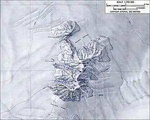
Topographic map of the Ames Range (1:250,000 scale) from USGS Mount Kosciusko
| Gardiner Ridge | |
|---|---|
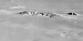 Aerial view of the Ames Range, Gardiner Ridge connects Mount Kauffman at the righthandend of the chain, to Mount Kosciuosko to its left. | |
| Highest point | |
| Coordinates | 75°39′S 132°26′W |
| Geography | |
 Gardiner Ridge Position in Antarctica | |
| Location | Marie Byrd Land, Antarctica |
| Parent range | Ames Range |
References
- "Gardiner Ridge". Geographic Names Information System. United States Geological Survey. Retrieved 2012-04-17.
![]() This article incorporates public domain material from the United States Geological Survey document: "Gardiner Ridge". (content from the Geographic Names Information System)
This article incorporates public domain material from the United States Geological Survey document: "Gardiner Ridge". (content from the Geographic Names Information System)
This article is issued from Wikipedia. The text is licensed under Creative Commons - Attribution - Sharealike. Additional terms may apply for the media files.