Georgia State Route 185
State Route 185 (SR 185) is a 12.90-mile (20.76 km) state highway located in the southeastern part of the U.S. state of Georgia. It lies entirely within Charlton County.
| ||||
|---|---|---|---|---|
 | ||||
| Route information | ||||
| Maintained by GDOT | ||||
| Length | 12.90 mi[1][2] (20.76 km) | |||
| Major junctions | ||||
| South end | ||||
| North end | ||||
| Location | ||||
| Counties | Charlton | |||
| Highway system | ||||
| ||||

Route description
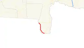
The highway begins at an intersection with SR 23/SR 121 at a point just north of the Florida state line (and near their southernmost point in the state). It heads northwest, skirting the nearby Florida state line to its west. County Road 120 (CR 120) is accessible via Reynolds Bridge Road. SR 185 continues to the northwest, through rural areas, until it meets its northern terminus, an intersection with SR 94. Geographically, it is the second-southernmost state highway in the state, after SR 23/SR 121, which have their southern terminus just a little further south than SR 185.[2]
Major intersections
The entire route is in Charlton County.
| Location | mi[2] | km | Destinations | Notes | |
|---|---|---|---|---|---|
| | 0.0 | 0.0 | Southern terminus | ||
| Moniac | 13.0 | 20.9 | Northern terminus | ||
| 1.000 mi = 1.609 km; 1.000 km = 0.621 mi | |||||
See also
.svg.png.webp) Georgia (U.S. state) portal
Georgia (U.S. state) portal U.S. roads portal
References
- Office of Information Services (December 31, 2002). "State Highway System Mileage in Each County Classified by State Route Number and Federal-Aid System" (PDF). Georgia Department of Transportation. Archived from the original (PDF) on September 26, 2007. Retrieved January 7, 2013.
- Google (June 5, 2013). "Route of SR 185" (Map). Google Maps. Google. Retrieved June 5, 2013.
External links
 Media related to Georgia State Route 185 at Wikimedia Commons
- Georgia Roads (Routes 181 - 200)
- Georgia State Route 185 on State-Ends.com