Gila Formation
The Gila Formation is a geologic formation found along the upper tributaries of the Gila River in Arizona and New Mexico.[1] Radiometric dating of interlayered lava flows yields an age of Miocene to Quaternary.[2][3]
| Gila Formation Stratigraphic range: Neogene | |
|---|---|
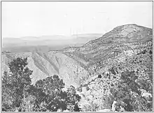 Gila conglomerate (left) faulted against Tertiary lavas at Silver Peak, New Mexico, USA | |
| Type | Formation |
| Thickness | 1,000–1,500 ft (300–460 m) |
| Lithology | |
| Primary | Conglomerate |
| Other | Sandstone, siltstone, basalt, dacite |
| Location | |
| Region | Arizona, New Mexico |
| Country | United States |
| Type section | |
| Named for | Gila River |
| Named by | G.K. Gilbert |
| Year defined | 1875 |
 Gila Formation (the United States) 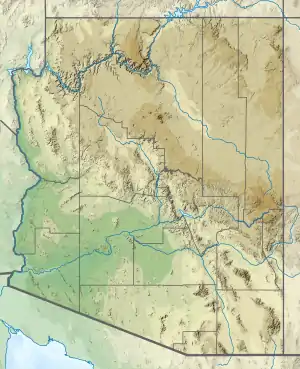 Gila Formation (Arizona) | |
Description
The formation is primarily conglomerate composed of clasts derived locally. There are also occasional thin sandstone and tuff beds and basalt flows. Total thickness is 1,000–1,500 feet (300–460 m).[1] Radiometric ages of interbedded basalt range from 12.1 Ma[2] to 1 Ma.[3]
History of investigation
The unit was first named as the Gila Conglomerate by G.K. Gilbert in 1875 from his participation in the Wheeler Survey. Only a type area was defined.[1] By 1903 F.L. Ransome had mapped the unit into the Globe area.[4] P.A. Wood divided the unit into the Bonita beds, Solomonsville beds, and Frye Mesa beds in 1960.[5] In 1963, L.A. Heindl raised the unit to group rank and divided it into the San Manuel, Quiburis, and Sacaton Formations,[6] but M.H. Krieger and coinvestigators removed the San Manuel and Quiburis Formations from the Gila and abandoned the Sacaton Formation, restoring the Gila to formation rank.[7] J.C. Ratte and coinvestigators redesignated the unit as the Gila Formation based on its diverse lithology.[2]
Footnotes
References
- Gilbert, G.K. (1875). "Report upon the geology of portions of Nevada, Utah, California, and Arizona, examined in the years 1871 and 1872". Publication of the Wheeler Survey. 3 (1): 17–187.
- Heindl, L.A. (1963). "Cenozoic geology in the Mammoth area, Pinal County, Arizona". U.S. Geological Survey Bulletin. 1141-E: E1–E41. doi:10.3133/b1141E.
- Krieger, M.H.; Cornwall, H.R.; Banks, N.G. (1974). "Big Dome Formation and revised Tertiary stratigraphy in the Ray-San Manuel area, Arizona". U.S. Geological Survey Bulletin. 1394-A: A54–A62. doi:10.3133/b1394A.
- Ransome, F.L. (1903). "Geology of the Globe copper district, Arizona". U.S. Geological Survey Professional Paper. Professional Paper. 12. doi:10.3133/pp12. Retrieved 30 August 2020.
- Ratte, J.C. (1989). "Geologic map of the Bull Basin quadrangle, Catron County, New Mexico". U.S. Geological Survey Geologic Quadrangle Map. GQ-1651. Retrieved 31 July 2020.
- Ratte, J.C.; Bove, D.J.; McIntosh, W.C. (1994). "Geologic map of the Milligan Mountain quadrangle, Catron County, New Mexico". U.S. Geological Survey Geologic Quadrangle Map. GQ-1736. Retrieved 31 July 2020.
- Wood, P.A. (1960). "[unknown title]". Arizona Geological Society Guidebook (2).