Glan (Nahe)
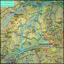
The Glan is a river in southwestern Germany, right tributary of the Nahe. It is approximately 68 km (42 miles) long. It rises in the Saarland, northwest of Homburg. It flows generally north, through Rhineland-Palatinate, and empties into the Nahe near Odernheim am Glan, at Staudernheim, across the Nahe from Bad Sobernheim. Other towns along the Glan are Altenglan, Glan-Münchweiler, Lauterecken and Meisenheim.
| Glan | |
|---|---|
 The source of the Glan in Höchen | |
 Catchment and course[1] | |
| Location | |
| Country | Germany |
| States | Saarland Rhineland-Palatinate |
| Reference no. | DE: 2546 |
| Physical characteristics | |
| Source | |
| • location | in Höchen |
| • coordinates | 49°23′29″N 7°16′33″E |
| • elevation | ca. 480 m above sea level (NHN) |
| Mouth | |
• location | After flowing through Odernheim below Staudernheim from the right into the Nahe |
• coordinates | 49°46′34″N 7°42′52″E |
• elevation | ca. 131 m above sea level (NHN) |
| Length | 89.67 km [2] |
| Basin size | 1,221.976 km² [2] |
| Basin features | |
| Progression | Nahe → Rhine → North Sea |
| River system | Rhine |
| Landmarks | Small towns: Bexbach, Lauterecken, Meisenheim |
| Tributaries | |
| • left | Kohlbach, Ohmbach, Kuselbach, Steinalp, Jeckenbach |
| • right | Mohrbach, Reichenbach, Talbach, (Wald)-Lauter, Odenbach, |
 Bridge over the Glan in Meisenheim
 Nature reserve near the confluence | |
Etymology
The Celtic root of the name comes either from glann (shining) or from glen (U-shaped valley).
References
- The colour change on the map on merging with the - also highlighted – Lauter represents the classification of the Glans downstream as a waterbody of the 1st order; analogous to the Vorfluter Nahe.
- Geoexplorer of the Rhineland-Palatinate Water Authority (Wasserwirtschaftsverwaltung Rheinland-Pfalz)
This article is issued from Wikipedia. The text is licensed under Creative Commons - Attribution - Sharealike. Additional terms may apply for the media files.