Glory Mountain
Glory Mountain is a 7,228-foot (2,203-metre) mountain summit located in the North Cascades Range in Chelan County of Washington state.[2] Glory Mountain is situated southeast of Trapper Lake on the shared border of North Cascades National Park and Glacier Peak Wilderness. The nearest higher peak is Trapper Mountain, 1.72 miles (2.77 km) to the west.[1] Precipitation runoff from the mountain drains into Cottonwood Creek and Flat Creek, both tributaries of the Stehekin River. An unofficially named secondary peak called Halleluja Peak 7,120+ ft (2,170+ m) lies 0.32 miles (0.51 km) to the west of the summit.[3]
| Glory Mountain | |
|---|---|
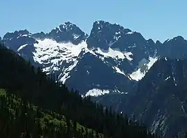 Glory Mountain left, Halleluja Peak right | |
| Highest point | |
| Elevation | 7,228 ft (2,203 m) [1] |
| Prominence | 1,348 ft (411 m) [1] |
| Coordinates | 48°25′56″N 120°58′49″W [1] |
| Geography | |
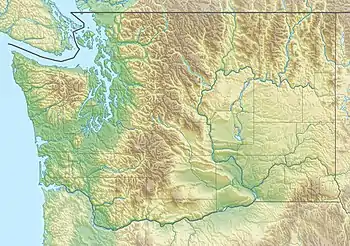 Glory Mountain  Glory Mountain Glory Mountain (the United States) | |
| Parent range | North Cascades |
| Topo map | USGS Goode Mountain |
| Geology | |
| Type of rock | Gneiss |
| Climbing | |
| Easiest route | Scrambling |
Climate
Glory Mountain is located in the marine west coast climate zone of western North America.[4] Most weather fronts originate in the Pacific Ocean, and travel northeast toward the Cascade Mountains. As fronts approach the North Cascades, they are forced upward by the peaks of the Cascade Range, causing them to drop their moisture in the form of rain or snowfall onto the Cascades (Orographic lift). As a result, the west side of the North Cascades experiences high precipitation, especially during the winter months in the form of snowfall. During winter months, weather is usually cloudy, but, due to high pressure systems over the Pacific Ocean that intensify during summer months, there is often little or no cloud cover during the summer.[4]
Geology
The North Cascades features some of the most rugged topography in the Cascade Range with craggy peaks and ridges, deep glacial valleys, and granite spires. Geological events occurring many years ago created the diverse topography and drastic elevation changes over the Cascade Range leading to the various climate differences. These climate differences lead to vegetation variety defining the ecoregions in this area.
The history of the formation of the Cascade Mountains dates back millions of years ago to the late Eocene Epoch.[5] With the North American Plate overriding the Pacific Plate, episodes of volcanic igneous activity persisted.[5] In addition, small fragments of the oceanic and continental lithosphere called terranes created the North Cascades about 50 million years ago.[5]
During the Pleistocene period dating back over two million years ago, glaciation advancing and retreating repeatedly scoured the landscape leaving deposits of rock debris.[5] The U-shaped cross section of the river valleys are a result of recent glaciation. Uplift and faulting in combination with glaciation have been the dominant processes which have created the tall peaks and deep valleys of the North Cascades area.
References
- "Glory Mountain, Washington". Peakbagger.com.
- "Glory Mountain". Geographic Names Information System. United States Geological Survey. Retrieved 2019-04-26.
- "Halleluja Peak, Washington". Peakbagger.com.
- Beckey, Fred W. Cascade Alpine Guide, Climbing and High Routes. Seattle, WA: Mountaineers Books, 2008.
- Kruckeberg, Arthur (1991). The Natural History of Puget Sound Country. University of Washington Press.