Goat Mountain (Glacier County, Montana)
Goat Mountain (8,831 ft (2,692 m)) is located in the Lewis Range, Glacier National Park in the U.S. state of Montana.[3] Goat Mountain rises above Otokomi Lake and Goat Lake in the east central section of Glacier National Park.[4]
| Goat Mountain | |
|---|---|
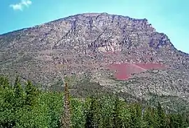 Goat Mountain seen from Sun Point | |
| Highest point | |
| Elevation | 8,831 ft (2,692 m) [1] NAVD 88 |
| Prominence | 1,066 ft (325 m) [1] |
| Coordinates | 48°42′16″N 113°35′30″W [2] |
| Geography | |
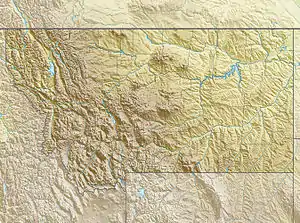 Goat Mountain Location in Montana  Goat Mountain Location in the United States | |
| Location | Glacier County, Montana, U.S. |
| Parent range | Lewis Range |
| Topo map | USGS Rising Sun |
| Climbing | |
| First ascent | Unknown |
| Easiest route | Scramble |
References
- "Goat Mountain, Montana". Peakbagger.com. Retrieved June 12, 2018.
- "Goat Mountain". Geographic Names Information System. United States Geological Survey. Retrieved June 12, 2018.
- Rising Sun, MT (Map). TopoQwest (United States Geological Survey Maps). Retrieved June 12, 2018.
- "Goat Mountain". SummitPost.org. Retrieved June 12, 2018.
.jpg.webp)
Goat Mountain to right of Saint Mary Lake (see annotations)
This article is issued from Wikipedia. The text is licensed under Creative Commons - Attribution - Sharealike. Additional terms may apply for the media files.