Golden Bay / Mohua
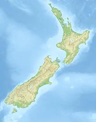
Golden Bay / Mohua is a shallow, paraboloid-shaped bay in New Zealand, near the northern tip of the South Island. An arm of the Tasman Sea, the bay lies northwest of Tasman Bay / Te Tai-o-Aorere and Cook Strait. It is protected in the north by Farewell Spit, a 26 km long arm of fine golden sand that is the country's longest sandspit. The Aorere and Tākaka rivers flow into the bay from the south.
| Golden Bay | |
|---|---|
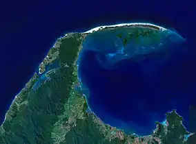 Landsat image | |
 Golden Bay | |
| Location | New Zealand |
| Coordinates | 40°40′S 172°50′E |
| Type | Bay |
It is part of the Tasman Region, one of the territorial authorities of New Zealand.
The bay was once a resting area for migrating whales and dolphins such as southern right whales[1] and humpback whales, and pygmy blue whales may be observed off the bay as well.[2]
The west and northern regions of the bay are largely unpopulated. Along its southern coast are the towns of Tākaka and Collingwood, and the Abel Tasman National Park. Separation Point, the natural boundary between Golden and Tasman Bays, is in the park. North-eastern parts of Kahurangi National Park are in Golden Bay.

It is known for being a popular tourist destination, because of its good weather and relaxed, friendly lifestyle. Beaches such as Tata Beach are popular locations for retirees and holiday homes.
History
Māori lived along the shores of Golden Bay from at least 1450, which is the earliest dated archaeological evidence (from carbon dating) yet found. In 2010 an extensive scientific study was made of Golden Bay by a team from Otago University led by Associate Professor Ian Barber.[3] They accurately plotted and investigated a large number of early Māori sites ranging from pā to kāinga to probable kumara gardens that stretch along the coastal arc from the base of Farewell Spit at Triangle Flat, 60 km eastwards to a pā site 10 km east of Separation Point.
The iwi who occupied this area in 1642 were the Ngāti Tūmatakōkiri from the North Island.
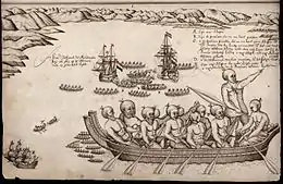
Dutch explorer Abel Tasman anchored in this bay in 1642. Ngāti Tūmatakōkiri rammed the Dutch ship's cockboat with a waka and four Dutch seamen were killed by Māori, prompting Tasman to name it Moordenaar's Bay (Murderers Bay). Archeological research has shown the Dutch had tried to land at a major agricultural area, which the Māori may have been trying to protect.[4] Barber postulated that the iwi may have been insecure in their control of the bay and its resources because of their own relatively recent arrival.
Little is known of the history of Ngāti Tūmatakōkiri people as they were extinguished by a Māori invasion during the Musket Wars about 1823.[5][6]
In 1642 Tasman saw at least 22 waka. He recorded that of the 11 waka that chased his ship, most had 17 men on board. This gives a total of about 200 men, with a likely population of about 500 people. Tasman had already been in the bay five days when attacked giving the Māori time to assemble an attack force.
Archaeological evidence has not shown any large settlements so it is likely that the iwi normally lived in whanau based groups scattered along the coast but mainly in the eastern bay at Ligar Beach, Tata Beach and Wainui Bay where there are 20 known archaeological sites in a 10 km zone.
In 1770, during his first voyage, English explorer James Cook included the bay as part of Blind Bay, but upon his second voyage to the bay in 1773 realised that it was in fact the location of Murderers Bay. The French explorer Jules Dumont d'Urville appears to have changed the name to Massacre Bay.
European settlement commenced in October 1842 with the Lovell family settling at Motupipi near the then existing Māori pa site. Prior to the Lovell's settling, in March of that year a Mr Tuckett had discovered coal on the beach near the Motupipi pa.[7] There was a report from May 1841, which also stated there was coal in the area.[8] In the 1840s, following the discoveries, the local population unsuccessfully sought to have it renamed Coal Bay.[9]
In 1846, Charles Heaphy and Thomas Brunner with their Maori guide Kehu, passed through Golden Bay on their journey to the West Coast. In 1850, Packard, Robinson and Lovell started the first sawmill in Tākaka and between 1852 and 1856 land was sold to various European immigrants in Golden Bay by some members of the local iwi but without the consent of the entire iwi. In 1855 William Gibbs bought 50 acres of land from local Maori and established the town of Gibbstown which later was renamed Collingwood.[10]
In the late 1850s, with the discovery of gold at Aorere, its name was changed to Golden Bay.[11][12] In the Great Depression, miners returned to search for any remaining gold in a government-subsidised prospecting scheme for the unemployed, and about 40 miners lived in a dozen huts around Waingaro Forks.[13]
The Abel Tasman National Park was established on 16 December 1942 which was 300 years exactly after Abel Tasman had visited Golden Bay. It was established thanks to the determined efforts of Perrine Moncrieff who was concerned about both a proposal to mill the trees around Totaranui in 1937 and a plan to build a road through the area.[14]
During the 1960s and the early 1970s, the Ministry of Works surveyed the land where the Heaphy Track now exists for a proposed road to link Golden Bay with the Karamea. This was encouraged by local authorities both in Golden Bay and on the West Coast. The project never progressed beyond this due to public opposition and a lack of funding from the government.[15]
The Northwest Nelson Forest Park was created in 1970 by amalgamating eight state forest parks. The Tasman Wilderness area was established in 1988[16] and this entire area was given the highest level of conservation protection in 1996 when it became the Kahurangi National Park in 1996. It is the second largest of New Zealand's national park and forms the majority of Golden Bay's interior.[17][18]
In December 2011 Golden Bay, as well as much of the Nelson and Tasman regions, were hit by heavy rain and flooding. It was described as a 1 in 500 year downpour for Tākaka. This affected many homes around the Pohara, Ligar Bay, Tata Beach and Wainui area. State Highway 60 between Tākaka and Collingwood was severely damaged at Bird's Hill.[19] [20] [21] The road to Totaranui, a popular isolated tourist destination in Tasman Bay, was badly damaged and was reopened on 29 June 2012.[22]
Ex Cyclone Gita hit Golden Bay in February 2018 and damaged state highway 60 over the Tākaka Hill isolating Golden Bay from the rest of the South Island. The road over Tākaka Hill was closed by 16 landslides.[23] Tākaka lost electricity and roads and bridges were damaged making them unusable.[24] Barges were required to bring in food supplies and keep the Fonterra dairy factory in operation in Tākaka.[25] It took a number of days for the NZ Transport Agency to reopen the road over Tākaka Hill to essential vehicles and those most urgently needing to leave the region.[26] The road has taken substantial work and time to repair and is expected to be fully repaired by the end of 2021[27]
In August 2014, the name of the bay was officially altered to Golden Bay / Mohua.[28]
Demographics
In 2006, Golden Bay had a population of 2256, growing to 2310 in 2013 and 2421 in 2018. The median age of the residents in 2018 was 49.0 years old. In terms of ethnicity, 95.4% of residents identified as European, 7.1% identified as Maori and 9.3% identified as of Maori descent. The majority of residents were born in New Zealand (76.7%). Many residents identified with no religion (67.7%) while a sizeable minority (20.6%) identified as Christian. Only 40.8% of residents were in full-time employment. The median income was $25,500 with 9.0% earning over $70,000.
In 2018, there were 1005 occupied private dwellings and a further 495 unoccupied private dwellings.[29]
Over the summer months, the population of Golden Bay increases significantly with holiday makers taking holidays near the Golden Bay beaches. Numbers of people staying in Golden Bay have been reported as swelling the population up to 25.000 people during the peak holiday season.[30][31][32]
Hydroelectricity
The Cobb Valley is the location of the Cobb Hydroelectric Power Station. The reservoir sits at 794 metres above sea level at the confluence of the Tākaka and Cobb rivers, The power station is situated 600 vertical metres below and provides 32 MW of power. The average annual output is 192 GWh.[33] It was built between 1936 and 1956. Construction was difficult due to the weather with an annual rainfall of over 2,200mm and snow and heavy frosts in winter.[34] The dam was originally planned to be concrete but this was deemed to be not suitable and an earth dam was constructed instead.[35] It first produced power in 1944.[36]
Dairy farming
In 2009, there were 83 dairy farms which supplied the Fonterra factory in Tākaka. The factory turned about 525,000 litres of milk each day into skim milk powder.[37]
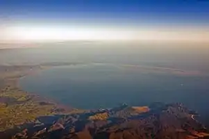 Golden Bay and Farewell Spit from the air |
 One of many beaches in Abel Tasman National Park |
References
- "Sighting of rare whale". Stuff.
- Torres G. L.. 2013. Evidence for an unrecognised blue whale foraging ground in New Zealand. New Zealand Journal of Marine and Freshwater Research 47(2). ResearchGate. Retrieved on 3 March 2017
- Anthropology, Social. "Associate Professor Ian Barber". www.otago.ac.nz.
- "First contact violence linked to food". The New Zealand Herald. 23 September 2010. Retrieved 23 September 2010.
- Musket Wars R. Crosby p 21.
- Current Anthropology. Vol 53, No 6. Dec 2012. Garden of Rongo. I Barber. University of Otago.
- Discovery of coal and freestone, Nelson Examiner and New Zealand Chronicle| volume=I| issue=4, 2 April 1842, Page 15
- Commercial prospects of New Zealand, New Zealand Gazette and Wellington Spectator| volume=II| issue=59, 29 May 1841, Page 3
- Auckland Extracts, Nelson Examiner and New Zealand Chronicle| volume=VI| issue=287, 4 September 1847, Page 105
- Golden Bay Museum display on the history of Golden Bay. Cited 2021
- McLintock, A. H.; George William Grindley (1966). "Golden Bay". Te Ara. Retrieved 14 September 2010.
- Advertisements, Colonist| volume=II| issue=172, 14 June 1859, Page 2
- White, Rebekah (July–August 2018). "Waingaro Forks Hut". New Zealand Geographic (152): 21.
- "Abel Tasman History". Abel Tasman. Retrieved 3 February 2021.
- Taonga, New Zealand Ministry for Culture and Heritage Te Manatu. "North-west Nelson". teara.govt.nz. Retrieved 3 February 2021.
- Barnett, Shaun (23 April 2017). "Wilderness Protection". Wilderlife. Retrieved 3 February 2021.
- Taonga, New Zealand Ministry for Culture and Heritage Te Manatu. "North-west Nelson". teara.govt.nz. Retrieved 3 February 2021.
- "Kahurangi: our newest national park". New Zealand Geographic. Retrieved 3 February 2021.
- "After the flood". New Zealand Geographic. Retrieved 3 February 2021.
- "Golden Bay Debris Flows / Project Examples / Landslides / Natural Hazards and Risks / Our Science / Home – GNS Science". www.gns.cri.nz. Retrieved 3 February 2021.
- "NZ's worst ever rainfall". Stuff. 11 September 2013. Retrieved 3 February 2021.
- "Road to Golden Bay beach to reopen". RNZ. 28 June 2012. Retrieved 3 February 2021.
- "GeoNet News". www.geonet.org.nz. Retrieved 3 February 2021.
- "Cyclone Gita: Restaurant closes shop as Takaka, near Nelson loses power". NZ Herald. Retrieved 3 February 2021.
- "Gita: Tourists still stranded in Golden Bay". RNZ. 21 February 2018. Retrieved 3 February 2021.
- "Escape coming for those stranded in Golden Bay by ex-Cyclone Gita". Stuff. 23 February 2018. Retrieved 3 February 2021.
- "Tākaka Hill repairs update – December 2020". createsend.com. Retrieved 3 February 2021.
- "NZGB decisions". Land Information New Zealand. August 2014. Archived from the original on 21 November 2015. Retrieved 7 November 2015.
- "2018 Census place summaries | Stats NZ". www.stats.govt.nz. Retrieved 30 January 2021.
- "Golden Bay: sun, sand, and secession". www.aa.co.nz. Retrieved 31 January 2021.
- "Golden Bay retailers crossing their fingers for a bumper summer". Stuff. 22 December 2018. Retrieved 31 January 2021.
- "Holiday gold in the Coromandel, Golden Bay". Newsroom. 10 December 2020. Retrieved 31 January 2021.
- "Cobb Power Station – Takaka River – Pelton Turbines – Cobb Lake Level – Trustpower". www.trustpower.co.nz. Retrieved 31 January 2021.
- "Cobb Dam | Engineering New Zealand". www.engineeringnz.org. Retrieved 31 January 2021.
- "The Cobb – The History of The Cobb River Hydro-Electric Power Scheme | NZETC". nzetc.victoria.ac.nz. Retrieved 31 January 2021.
- "Cobb scheme still a powerhouse after 75 years". Stuff. 31 May 2019. Retrieved 31 January 2021.
- Malthus, Nigel. "Down to the sea in barges". ruralnewsgroup.co.nz. Retrieved 31 January 2021.
| Authority control |
|---|