Goner, Rajasthan
Goner is a village of over 12,000 inhabitants in India. It is situated in Sanganer tehsil of Jaipur district, Rajasthan, 20 kilometres (12 mi) south of state capital Jaipur.
Goner | |
|---|---|
village | |
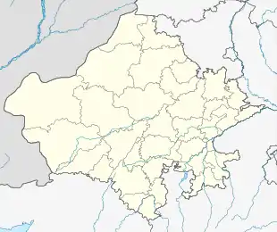 Goner Location in Rajasthan, India  Goner Goner (India) | |
| Coordinates: 26.7795°N 75.9123°E | |
| Country | India |
| State | Rajasthan |
| District | Jaipur |
| Area | |
| • Total | 2.51 km2 (0.97 sq mi) |
| Elevation | 383 m (1,257 ft) |
| Population | |
| • Total | 12,049 |
| • Density | 4,800/km2 (12,000/sq mi) |
| Languages | |
| • Official | Hindi , Rajasthani |
| Time zone | UTC+5:30 (IST) |
| PIN | 303905 |
| Nearest city | Jaipur |
| Climate | Hot and dry (Köppen) |
Geography
The village is located at 26.7795°N 75.9123°E,[2] at an altitude of 383 metres (1,257 ft), and its area is 251.0 hectares (2.510 km2).[1]
The Dravyavati River passes through Goner.[3]
Demographics
As of 2011 the population was 6,049. The literacy rate was 77% and the sex ratio was 899 female per 1000 male.
Administration
Tehsil level local administration is conducted at the headquarters at Sanganer, subdivision of Jaipur district.
the gram panchayat level local administration is conducted as Goner and current representative or sarpanch is Sunita Sharma w/o Prakash Sharma (Jaldhari)
The village falls within Bagru assembly constituency of the Rajasthan Legislative Assembly. The current representative is Ganga Devi.
The Lok Sabha constituency is Jaipur, and the current MP is Ramcharan Bohara.
References
- "District Census Handbook, Jaipur" (PDF). Government of India. 16 June 2014. p. 370.
- "Goner PIN Code". www.postalpinzipcodes.com.
- "47-km long bicycle track proposed along Dravyavati River". The PinkCity Post. 19 August 2017.