Grade II* listed buildings in Wellingborough (borough)
There are over 20,000 Grade II* listed buildings in England. This page is a list of these buildings in the district of Wellingborough in Northamptonshire.
Wellingborough
| Name | Location | Type | Completed [note 1] | Date designated | Grid ref.[note 2] Geo-coordinates |
Entry number [note 3] | Image |
|---|---|---|---|---|---|---|---|
| 22 High Street | Easton Maudit, Wellingborough | House | c. 1500 | 2 August 1972 | SP8883258738 52°13′11″N 0°42′04″W |
1040784 |  |
| Ecton Hall | Ecton, Wellingborough | Country House | 16th century | 28 May 1954 | SP8293963602 52°15′52″N 0°47′10″W |
1189661 | .jpg.webp) Ecton Hall |
| Ecton House | Ecton, Wellingborough | Vicarage | c. 1693 | 28 May 1954 | SP8284463613 52°15′52″N 0°47′15″W |
1189693 | 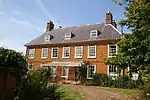 Ecton House |
| Laundry and Game Larder about 30m north-west of Ecton Hall | Ecton, Wellingborough | Estate Laundry | Mid 18th century | 13 May 1986 | SP8292363640 52°15′53″N 0°47′11″W |
1189673 | |
| Summerhouse about 250m north-east of Ecton Hall | Ecton, Wellingborough | Summerhouse | Late 17th century or mid 18th century | 28 May 1954 | SP8302463752 52°15′56″N 0°47′05″W |
1040786 | |
| The Manor House | Ecton, Wellingborough | Manor House | 1694 | 28 May 1954 | SP8277863402 52°15′45″N 0°47′19″W |
1040756 | |
| Charity House and Attached Walls | Finedon, Wellingborough | House | 1712 | 23 September 1950 | SP9135971947 52°20′17″N 0°39′38″W |
1371768 | |
| Vicarage, Chantry House, Bede House and attached Carriage House | Finedon, Wellingborough | House | 1688 | 23 September 1950 | SP9119371975 52°20′18″N 0°39′47″W |
1371744 | |
| Church of St Nicholas | Great Doddington, Wellingborough | Church | Late 12th century | 28 May 1954 | SP8811564837 52°16′29″N 0°42′36″W |
1189920 | 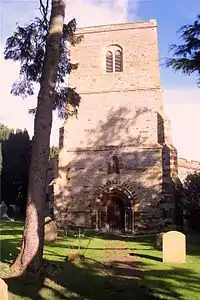 Church of St Nicholas |
| Church of All Saints | Great Harrowden, Wellingborough | Church | 12th century | 28 May 1954 | SP8802870846 52°19′43″N 0°42′35″W |
1040771 | .jpg.webp) Church of All Saints |
| Gates, Gatepiers and Railings about 90m west of Harrowden Hall | The Slips, Great Harrowden, Wellingborough | Gate | Early 18th century | 28 May 1954 | SP8810070873 52°19′44″N 0°42′31″W |
1190526 | .jpg.webp) Gates, Gatepiers and Railings about 90m west of Harrowden Hall |
| Statue about 30m north-east of Harrowden Hall | The Slips, Great Harrowden, Wellingborough | Statue | Early 18th century | 26 May 1981 | SP8823370871 52°19′44″N 0°42′24″W |
1040732 | |
| Statue about 30m south-east of Harrowden Hall | The Slips, Great Harrowden, Wellingborough | Statue | Early 18th century | 26 May 1981 | SP8822870825 52°19′42″N 0°42′24″W |
1371697 | |
| Statue about 60m south-east of Harrowden Hall | The Slips, Great Harrowden, Wellingborough | Statue | Early 18th century | 26 May 1981 | SP8825870820 52°19′42″N 0°42′23″W |
1040733 | |
| The Manor House | Great Harrowden, Wellingborough | Manor House | 13th century | 28 May 1954 | SP8793070866 52°19′44″N 0°42′40″W |
1371674 | |
| Church of St Mary | Grendon, Wellingborough | Church | Mid C12-C14 | 28 May 1954 | SP8788560446 52°14′07″N 0°42′52″W |
1190552 | .jpg.webp) Church of St Mary |
| Grendon Hall | Grendon, Wellingborough | Country House | Late 16th century | 28 May 1954 | SP8803860823 52°14′19″N 0°42′44″W |
1040746 |  Grendon Hall |
| Church of St Leonard | Hardwick, Wellingborough | Church | 13th century | 28 May 1954 | SP8506869777 52°19′10″N 0°45′12″W |
1040750 | 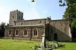 Church of St Leonard |
| Manor Farmhouse | Hardwick, Wellingborough | Farmhouse | 14th century | 28 May 1954 | SP8510869753 52°19′09″N 0°45′10″W |
1293700 | |
| Chester House and attached Cottage to East and attached Walls to South and West | Irchester, Wellingborough | Farmhouse | Late 17th century and 18th century | 28 May 1954 | SP9186466879 52°17′33″N 0°39′16″W |
1371729 | |
| Church of St Peter | Isham, Wellingborough | Church | Late 12th century to 14th century | 28 May 1954 | SP8850073947 52°21′23″N 0°42′07″W |
1040722 | 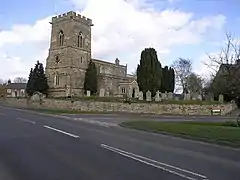 Church of St Peter |
| Church of St Mary | Little Harrowden, Wellingborough | Church | Late 12th century | 28 May 1954 | SP8715971679 52°20′11″N 0°43′20″W |
1371694 | 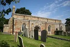 Church of St Mary |
| Church of All Saints | Mears Ashby, Wellingborough | Church | C12-C14 | 28 May 1954 | SP8384666653 52°17′30″N 0°46′20″W |
1040692 | 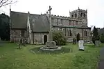 Church of All Saints |
| Mears Ashby Hall | Mears Ashby, Wellingborough | Country House | 1637 | 28 May 1954 | SP8397766416 52°17′22″N 0°46′13″W |
1040699 | |
| Church of St Mary | Orlingbury, Wellingborough | Church | c. 1843 | 2 August 1972 | SP8595272362 52°20′33″N 0°44′23″W |
1040666 | 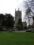 Church of St Mary |
| Gatepier about 45m north-east of the Old Rectory | Orlingbury, Wellingborough | Gate Pier | Mid 18th century | 2 August 1972 | SP8613472291 52°20′31″N 0°44′14″W |
1371724 | |
| Orlingbury Hall and attached Wall and Outbuildings to North East | Orlingbury, Wellingborough | Country House | 16th century | 28 May 1954 | SP8611872174 52°20′27″N 0°44′15″W |
1040668 | |
| The Old Rectory | Orlingbury, Wellingborough | House | 1986 | 28 May 1954 | SP8614072238 52°20′29″N 0°44′13″W |
1191565 | |
| Church of St Peter and St Paul | Sywell, Wellingborough | Church | 12th century | 28 May 1954 | SP8216767210 52°17′49″N 0°47′48″W |
1040676 | 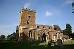 Church of St Peter and St Paul |
| Sywell Hall | Sywell, Wellingborough | Country House | c. 1600 | 28 May 1954 | SP8228167372 52°17′54″N 0°47′41″W |
1040679 | |
| Church of St Mary the Virgin | Wilby, Wellingborough | Church | 13th century | 28 May 1954 | SP8666466174 52°17′13″N 0°43′51″W |
1040680 | 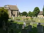 Church of St Mary the Virgin |
| Wilby House | Wilby, Wellingborough | Country House | Late 17th century and early 18th century | 28 May 1954 | 49°46′01″N 7°33′26″W | 1192006 | |
| Church of St Mary | Wollaston, Wellingborough | Church | 13th century | 28 May 1954 | SP9087563079 52°15′30″N 0°40′12″W |
1286637 | 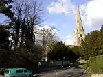 Church of St Mary |
| All Hallows Church Hall | Wellingborough | Church Hall | C20 | 23 September 1950 | SP8911967965 52°18′09″N 0°41′40″W |
1040619 | |
| The Golden Hind Hotel and Coleman Bird Associates Shop | Wellingborough | Courtyard | c. 1645 | 9 June 1970 | SP8920067778 52°18′03″N 0°41′36″W |
1286782 | 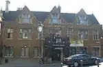 The Golden Hind Hotel and Coleman Bird Associates Shop |
| United Reformed Church | Wellingborough | Church | c. 1875 | 9 June 1970 | SP8897868001 52°18′11″N 0°41′47″W |
1191513 | 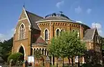 United Reformed Church |
Notes
- The date given is the date used by Historic England as significant for the initial building or that of an important part in the structure's description.
- Sometimes known as OSGB36, the grid reference is based on the British national grid reference system used by the Ordnance Survey.
- The "List Entry Number" is a unique number assigned to each listed building and scheduled monument by Historic England.
External links
![]() Media related to Grade II* listed buildings in Northamptonshire at Wikimedia Commons
Media related to Grade II* listed buildings in Northamptonshire at Wikimedia Commons
This article is issued from Wikipedia. The text is licensed under Creative Commons - Attribution - Sharealike. Additional terms may apply for the media files.