Grade II listed buildings in the London Borough of Bexley
Grade II
| Name | Location | Type | Completed [note 1] | Date designated | Grid ref.[note 2] Geo-coordinates |
Entry number [note 3] | Image |
|---|---|---|---|---|---|---|---|
| 8 Upton Road | Bexleyheath | House | 17 December 1980 | 51°27′27″N 0°07′52″E | 1064205 |  | |
| 10 to 16 Burnt Oak Lane | Sidcup | House | 11 September 1985 | 51°26′14″N 0°06′05″E | 1359401 | 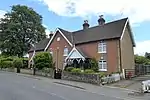 10 to 16 Burnt Oak Lane | |
| 25 and 27 Halfway Street | Sidcup | House | 17 December 1980 | 1188383 | .jpg.webp) 25 and 27 Halfway Street | ||
| 33 and 35 Halfway Street | Sidcup | House | 17 December 1980 | 51°26′11″N 0°05′59″E | 1359412 | | |
| 152 and 154 North Cray Road | North Cray | House | 17 December 1980 | 51°25′49″N 0°08′21″E | 1064237 | 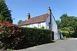 152 and 154 North Cray Road | |
| King's Head | Bexley | Pub | 1 October 1953 | TQ4951373622 51°26′31″N 0°09′00″E |
1064244 | ||
| Royal Oak | Bexleyheath | Pub | 19th century | 17 December 1980 | TQ4783574818 51°27′09″N 0°07′40″E |
1064234 |
.jpg.webp)
.jpg.webp)
Notes
- The date given is the date used by Historic England as significant for the initial building or that of an important part in the structure's description.
- Sometimes known as OSGB36, the grid reference is based on the British national grid reference system used by the Ordnance Survey.
- The "List Entry Number" is a unique number assigned to each listed building and scheduled monument by Historic England.
External links
 Media related to Grade II listed buildings in the London Borough of Bexley at Wikimedia Commons
This article is issued from Wikipedia. The text is licensed under Creative Commons - Attribution - Sharealike. Additional terms may apply for the media files.