Grand Aréa
The Grand Aréa is a 2.869 metres high[2] mountain of the Cottian Alps located in the French department of Hautes-Alpes.[1]
| Grand Aréa | |
|---|---|
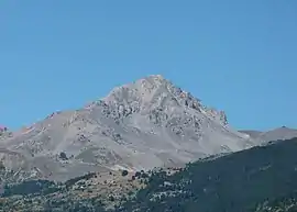 View from Briançon, showing the south-east face | |
| Highest point | |
| Elevation | 2,869 m (9,413 ft) [1] |
| Listing | Alpine mountains 2500-2999 m |
| Coordinates | 44°58′48″N 6°34′22″E |
| Geography | |
 Grand Aréa Location in the Alps | |
| Location | Provence-Alpes-Côte d'Azur, France |
| Parent range | Cottian Alps |
| Climbing | |
| Easiest route | Hike |
Features
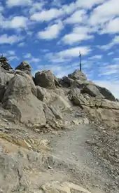
Summit of the mountain
The mountain stands in the Massif des Cerces and on the watershed between the valleys of the Guisane and the Clarée, NW of the Col du Granon. The ridge continues westwards with the Col de Buffère and then towards the Pointe des Cerces.
Access to the summit
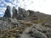
Footpath from Col de Buffère
The summit of the Grand Aréa can be reached by footpaths starting from several neighbouring locations. The hike from the Clarée valley thorough Col de Buffère is considered quite an easy and rewarding walk.[3] The mountain is also a well known destination for ski mountaineering.[4]
Mountain huts
- Refuge de Buffère (2.076 m).
References
- "Géoportail" (in French). IGN. Retrieved 2019-09-27.
- Royet, Paul; Bonelli, Stéphane (2013). Digues maritimes et fluviales de protection contre les submersions - 2e colloque national - Digues 2013 (in French). Lavoisier. p. 165. ISBN 9782746295360. Retrieved 2019-09-20.
- fyplom (2010-08-05). "Grand Aréa da Nevache" (in Italian). Retrieved 2019-09-20.
- Cabau, Emmanuel; Galley, Hervé (2015). Ski de randonnée Hautes Alpes: Ecrins – Queyras – Arves – Cerces – Parpaillon – Dévoluy (in French). Editions Olizane. p. 15.
Maps
- French official cartography (Institut géographique national - IGN); on-line version: www.geoportail.fr
External links
 Media related to Grand Aréa at Wikimedia Commons
- "Le Grand Aréa" (in French). camptocamp.org.
This article is issued from Wikipedia. The text is licensed under Creative Commons - Attribution - Sharealike. Additional terms may apply for the media files.