Grenff
The Grenff, also Grenf, is an approximately 21.9 km[1] long, right-hand or southeasterly tributary of Schwalm in East Hesse Highlands in North Hesse Schwalm-Eder-Kreis and belongs to the river system and catchment area of the Weser.
| Grenff | |
|---|---|
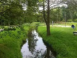 Grenff at Neukirchen | |
| Location | |
| Country | Germany |
| State | Hesse |
| Physical characteristics | |
| Mouth | |
• location | Schwalm |
• coordinates | 50°53′5″N 9°15′25″E |
| Length | 21.9 km (13.6 mi) [1] |
| Basin size | 86.4 km2 (33.4 sq mi) [1] |
| Basin features | |
| Progression | Schwalm→ Eder→ Fulda→ Weser→ North Sea |
Course
The Grenff rises in Ottrauer Highland, a part of the Fulda-Haune Plateau in East Hesse Highlands, in the transition area to the Knüllgebirge. The source is 1.2 km southeast of the village Görzhain (municipality Ottrau) in a clearing of the northern flank of the Frohnkreuzkopf (about 530 m above sea level (NN)), the western spur of the Rimberg (591.8 m), at about 395 m elevation.
Initially flows the Grenff which runs predominantly north-west, to and through Görzhain. From there on the Bad Hersfeld–Treysa railway (also Knüllwald railway) runs through the Grenff valley. It passes along the settlement Bahnhof Ottrau and a number of watermills (Boßmühle, Steinmühle, Lenzenmühle, Schneidmühle) and the village Kleinropperhausen. Then the Grenff flows through the riverside towns Nausis, after which it flows past the Bruchmühle, Neukirchen, Rückershausen, after which it passes the Sängermühle, and Riebelsdorf. Thereafter, the river passes the station Zella and Klinkemühle. At the village of Loshausen (Willingshausen municipality) it flows into the Eder tributary Schwalm that comes from the south, after overcoming of approximately 181 m difference in altitude.
Catchment and tributaries
The drainage basin of Grenff includes 86.406 km².[1] Its tributaries are (orographic allocation (l. = on the left side, r. = on the right side) , river length and confluence location, Grenff river kilometer (starting from the mouth )[1]:
- Reinsbach (r. 1.5 km) above Görzhain (near km 21)
- Weissenborn (r. 2.2 km), in Görzhain (at km 20.05)
- Leutschwasser (l. 2, 2 km), in Görzhain (at km 19.55)
- Schorbach (r. 5.2 km), at the Stone mill (near km 17,05)
- Otter (l. 5.6 kilometers) above the Lenz mill (at km 15.8)
- Wallebach (l. 2.5 km), in Nausis (near 12.8 km)
- Fischbach (l. 1.5 km), in Nausis (near 11.9 km)
- Damersbach (r. 3.3 km), below Nausis (near 11.6 km)
- Buchenbach (r. 7.7 kilometers) above Neukirchen (near km 9.8)
- Urbach (r. 7.3 km) Neukirchen (near km 8.1)
- Goldbach (r. 2.9 km), at Rückershausen (in km 6.1)
External links
![]() Media related to Grenff at Wikimedia Commons
Media related to Grenff at Wikimedia Commons