Grovers Cliff
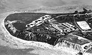
Grovers Cliff is a shoreline escarpment at Broad Sound near the Port of Boston and by extension, the landform extending into the sea (headland) that is the "Highlands" section of Winthrop, Massachusetts.[2] The headland is at the north end of Winthrop Beach[2] and is noted for an 1847 survey station,[3] WWI & II fortifications and a Cold War nuclear bunker used by the US Army, USCG, USN, USAF, and FAA as Fort Heath, the eponym of the landform's current apartment complex. A northern area of the headland is the municipal Small Park and the remainder is primarily the Fort Heath Apartments. Streets include Highland Avenue and Pond Street which had been constructed by the 1930s at the perimeter of Fort Heath.
| Grovers Cliff | |
|---|---|
 | |
| Location | Massachusetts, United States |
| Coordinates | 42°23′25″N 070°58′08″W[1] |
| Geology | Escarpment & Headland |
References
- "Grovers Cliff (613349)". Geographic Names Information System. United States Geological Survey. Retrieved 2013-03-17.
- Wing, Betty (July 19, 2012). "Fort Heath and Fort Dawes -- Winthrop MA". The Pye Plate.
Fort Heath was in a section of the town called the Highlands. This area was hilly compared to the rest of the town. Winthrop Beach ended its northward trek as the land began to get hillier and rockier, ending in a headland in the Highlands known as Grover’s Cliff
- Sutherland, O.P.--U.S. Coast and Geodetic Survey (1922). Triangulation in Massachusetts (Special Publications No. 76) (Report). Government Printing Office. Retrieved 2013-03-19.
This article is issued from Wikipedia. The text is licensed under Creative Commons - Attribution - Sharealike. Additional terms may apply for the media files.