Guam Highway 3
Guam Highway 3 (GH-3) is one of the primary automobile highways in the United States territory of Guam.
| ||||
|---|---|---|---|---|
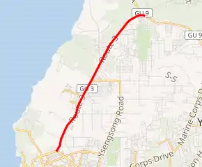
GH-3 highlighted in red | ||||
| Route information | ||||
| Maintained by Guam Department of Public Works | ||||
| Major junctions | ||||
| South end | ||||
| North end | ||||
| Highway system | ||||
Guam Highways
| ||||

Route description
It runs in a south to north direction, from a junction with GH-1 near the Micronesia Mall in the southern community of Tamuning in a general northeasterly direction to the community of Dededo, where it meets GH-3A and GH-9. In between, it passes the United States Naval Communications Station Finegayan and the Federal Aviation Administration headquarters on the island.[1]
Major intersections
| Location | mi | km | Destinations | Notes | |
|---|---|---|---|---|---|
| Tamuning | Southern terminus | ||||
| Gugagon | |||||
| Dededo | Northern terminus | ||||
| 1.000 mi = 1.609 km; 1.000 km = 0.621 mi | |||||
Suffixed route
| |
|---|---|
| Location | Tamuning–Dededo |
Guam Highway 3A (GH-3A) connects GH-3 and GH-9 to Ritidan Point at the northern tip of the island of Guam in Dededo.
References
- Map of Guam U.S.A. (Map). Franko's Maps, Ltd., Guam Visitors Bureau. 2007. § C3–B4.
This article is issued from Wikipedia. The text is licensed under Creative Commons - Attribution - Sharealike. Additional terms may apply for the media files.