Guanajibo River
The Guanajibo River (Spanish: Río Guanajibo) is a river that runs through Hormigueros, Cabo Rojo, Mayagüez, San Germán, and Sabana Grande in Puerto Rico.[2][3]
| Guanajibo River | |
|---|---|
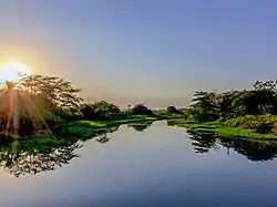 Guanajibo River in Cabo Rojo | |
| Native name | Río Guanajibo |
| Location | |
| Commonwealth | Puerto Rico |
| Municipality | Hormigueros, Cabo Rojo, Mayagüez, San Germán, and Sabana Grande |
| Physical characteristics | |
| Length | 19 mi (31 km)[1] |
Flood control project
In mid 2018, the United States Army Corps of Engineers announced it would be undertaking a major flood control project of the river, with a $60 million budget.[4][5]
See also
References
- Puerto Rico Water Resources. A progress Report. Water Resources Bulletin No. 4. Prepared by the United states Geological Survey in cooperation with The Commonwealth of Puerto Rico. 1964
- "Rios de Puerto Rico" (in Spanish). Archived from the original on October 23, 2008.
- "Jacksonville District Navigable Waters Lists" (PDF). saj.usace.army.mil. SAJ. Archived (PDF) from the original on 2017-01-26. Retrieved 18 February 2019.
- "USACE: $3.348 billion go toward reducing flood risk in Florida, Puerto Rico and USVI". Caribbean Business. 6 July 2018.
- https://www.saj.usace.army.mil/Portals/44/docs/CongressionalFS/R/Rio_Guanajibo_PR_C_CFS14.pdf
- U.S. Geological Survey Geographic Names Information System: Río Guanajibo
This article is issued from Wikipedia. The text is licensed under Creative Commons - Attribution - Sharealike. Additional terms may apply for the media files.