Ha Lejone
Ha Lejone is a village in the Leribe District of northern Lesotho. It is on a ridge above a bend of the Malibamat'so River, 15 kilometres (9.3 mi) east of the Mafika-Lisiu Pass,[1][2] which links Ha Lejone with the community of Pitseng.
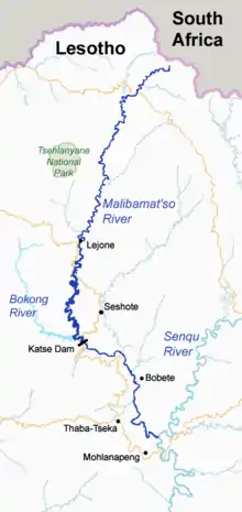
Course of the Malibamat'so River in northern Lesotho. Map data from Open Street Maps.
It is also the northern extent of the high water backed up by the Katse Dam, 25 kilometres (16 mi) to the south. There is a bridge across the river just south of the village.[3]
References
- 29°03′52″S 28°24′22″E Mafika-Lisiu Pass
- "Mafika-Lisiu Pass". Google Maps. Google. Retrieved 4 March 2018.
- "Location of Lejone village". Google Maps. Google. Retrieved 4 March 2018.
- Fitzpatrick, M., Blond, B., Pitcher, G., Richmond, S., and Warren, M. (2004) South Africa, Lesotho and Swaziland. Footscray, VIC: Lonely Planet.
This article is issued from Wikipedia. The text is licensed under Creative Commons - Attribution - Sharealike. Additional terms may apply for the media files.