Haarlemmerliede en Spaarnwoude
Haarlemmerliede en Spaarnwoude [ˌɦaːrlɛmərˈlidə ʔɛn ˌspaːrnˈʋʌudə] (![]() listen) is a former municipality in the Netherlands, located in the province of North Holland. It had a population of 5,760 in August 2017. On 1 January 2019, it merged with the municipality of Haarlemmermeer.[2]
listen) is a former municipality in the Netherlands, located in the province of North Holland. It had a population of 5,760 in August 2017. On 1 January 2019, it merged with the municipality of Haarlemmermeer.[2]
Haarlemmerliede en Spaarnwoude | |
|---|---|
Former municipality | |
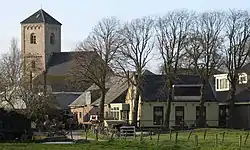 Spaarnwoude town centre | |
 Flag .svg.png.webp) Coat of arms | |
.svg.png.webp) Location in North Holland | |
| Coordinates: 52°23′N 4°45′E | |
| Country | Netherlands |
| Province | |
| Established | 8 September 1857[1] |
| Disestablished | 1 January 2019[2] |
| Government | |
| • Body | Municipal council |
| • Mayor | Pieter Heiliegers (VVD) |
| Area | |
| • Total | 21.19 km2 (8.18 sq mi) |
| • Land | 19.24 km2 (7.43 sq mi) |
| • Water | 1.95 km2 (0.75 sq mi) |
| Elevation | 0 m (0 ft) |
| Time zone | UTC+1 (CET) |
| • Summer (DST) | UTC+2 (CEST) |
| Postcode | 1165, 2064–2065 |
| Area code | 020 |
| Website | www |
The municipality was bordered by Zaanstad to the north, Amsterdam to the east, Haarlemmermeer to the south, Haarlem to the west and Velsen to the northwest.
Population centres
The municipality of Haarlemmerliede en Spaarnwoude consisted of the following cities, towns, villages and/or districts: Haarlemmerliede, Halfweg, Penningsveer, Spaarndam (partly), Spaarnwoude, Vinkebrug.
Topography
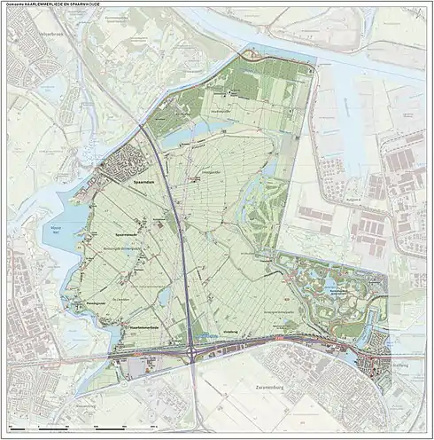
Dutch topographic map of the municipality of Haarlemmerliede en Spaarnwoude, June 2015
History
The municipality was formed on 8 September 1857, through the merger of the former municipalities of Haarlemmerliede and Spaarnwoude.[1]
On 22 September 1863, Houtrijk en Polanen and Zuidschalkwijk were added to the municipality,[1] of which Zuidschalkwijk was subsequently annexed by the city of Haarlem.
During the construction of the North Sea Canal (completed 1867), large portions of the IJ Bay were enclosed with dikes and made into polders, thereby enlarging the area of the municipality significantly. On the other hand, Haarlemmerliede en Spaarnwoude lost large areas to the cities of Haarlem and Amsterdam in 1927, 1963, and 1970.
On 1 January 2019, the municipality of Haarlemmerliede en Spaarnwoude was abolished and merged with the municipality of Haarlemmermeer.[2]

Local government
The municipal council of Haarlemmerliede en Spaarnwoude consisted of 11 seats, which in the last configuration were divided as follows:
References
- Ad van der Meer and Onno Boonstra, Repertorium van Nederlandse gemeenten, KNAW, 2011.
- "Gemeentelijke indeling op 1 januari 2019" (in Dutch). CBS. Retrieved 1 January 2019.
- "Burgemeester en wethouders" [Mayor and aldermen] (in Dutch). Gemeente Haarlemmerliede en Spaarnwoude. Archived from the original on 4 March 2014. Retrieved 4 March 2014.
- "Kerncijfers wijken en buurten 2020" [Key figures for neighbourhoods 2020]. StatLine (in Dutch). CBS. 24 July 2020. Retrieved 19 September 2020.
- "Postcodetool for 1165MJ". Actueel Hoogtebestand Nederland (in Dutch). Het Waterschapshuis. Retrieved 4 March 2014.
External links
 Media related to Haarlemmerliede en Spaarnwoude at Wikimedia Commons